Comfort, Texas
| Comfort, Texas | |
|---|---|
| CDP | |
|
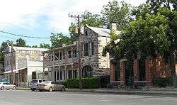
Historic downtown Comfort | |
 Location of Comfort, Texas | |
 | |
| Coordinates: 29°58′10″N 98°54′26″W / 29.96944°N 98.90722°WCoordinates: 29°58′10″N 98°54′26″W / 29.96944°N 98.90722°W | |
| Country | United States |
| State | Texas |
| County | Kendall |
| Area | |
| • Total | 3.2 sq mi (8.3 km2) |
| • Land | 3.2 sq mi (8.3 km2) |
| • Water | 0.0 sq mi (0.0 km2) |
| Elevation | 1,427 ft (435 m) |
| Population (2010) | |
| • Total | 2,363 |
| • Density | 735.6/sq mi (284.0/km2) |
| Time zone | Central (CST) (UTC-6) |
| • Summer (DST) | CDT (UTC-5) |
| ZIP code | 78013 |
| Area code(s) | 830 |
| FIPS code | 48-16228[1] |
| GNIS feature ID | 1333183[2] |
Comfort is a census-designated place (CDP) in Kendall County, Texas, United States. The population was 2,363 at the 2010 census. It is part of the San Antonio Metropolitan Statistical Area.
History
Comfort was established in 1854 by German immigrants, who were Freethinkers and abolitionists.[3] Ernst Hermann Altgelt, at the age of 22, is credited with surveying and measuring the lots that would later be sold to the incoming German immigrants.[4] He stayed and married Emma (Murck) Altgelt, and they raised their nine children in the township of Comfort. Fritz and Betty Holekamp built the first house in Comfort having started construction before Comfort's official founding on September 3, 1854.[5] The first churches were not established in Comfort until 1900.[6] After some controversy, a cenotaph honoring "the Founding Freethinkers" was dedicated on November 2, 2002.[7]
The downtown area is possibly one of the most well-preserved historic business districts in Texas. There are well over 100 structures in the area dating back to the 19th century, and seven of them were designed by the noted architect Alfred Giles.[8] Mr. Giles lived in San Antonio, and he would ride horses, the stagecoach, and later the train to check his building sites in Comfort.[9] Most of the population today is composed of descendants of those original pioneer families of the 1850s and the 1860s.[10]
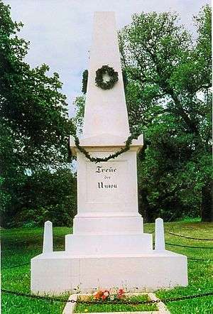
Comfort is also known for a tragic event that took place during the Civil War. The Treue der Union Monument ("Loyalty to the Union") was dedicated in honor of 35 men who died at the Battle of the Nueces, which took place because they opposed the state's secession from the Union. The German settlers were killed on their way to Mexico during the Civil War. They were attacked by Confederate forces near Brackettville on August 10, 1862. The bodies were not buried and the bones were retrieved and placed here in 1865. The monument was erected in 1866.[11][12]
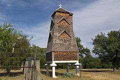
In 1918, Albert Steves erected a Hygieostatic Bat Roost on his family farm in Comfort. This roost was built to attract bats in an effort to control mosquito populations by natural means. It was originally researched and developed by Dr. Charles Agustus Rosenheimer Campbell of San Antonio. The idea was to use bats against malaria carrying mosquitos. At one time, there were sixteen bat roosts built in the United States and Europe, of which only two sites now remain — one in Comfort and one in the Florida Keys.[13] [14]
Darmstadt Society of Forty
Some of the early settlers in Comfort migrated from the collapsed Fisher-Miller Land Grant experimental colonies of the Darmstadt Society of Forty.
Geography
Comfort is located at 29°58′10″N 98°54′26″W / 29.969566°N 98.907087°W (29.969566, -98.907087).[15] This is 15 miles (24 km) northwest of Boerne, 45 miles (72 km) northwest of Downtown San Antonio, and 72 miles (116 km) west of Austin. The town is at the junction of I-10 and State HWY 87. I-10 has two exits for Comfort and HWY 87 takes you to Fredericksburg if you go north.
According to the United States Census Bureau, the CDP has a total area of 3.2 square miles (8.3 km2), of which, 3.2 square miles (8.3 km2) of it is land and 0.31% is water.
Historical Population
- 1924 = 713
- 1960 = 1,212
- 1990 = 1,477
- 2000 = 2,358
- 2010 = 2,363
Demographics
As of the census[1] of 2000, there were 2,358 people, 799 households, and 603 families residing in the CDP. The population density was 735.6 people per square mile (283.6/km2). There were 917 housing units at an average density of 286.1 per square mile (110.3/km2). The racial makeup of the CDP was 76.34% White, 0.51% African American, 1.19% Native American, 0.13% Asian, 0.21% Pacific Islander, 18.70% from other races, and 2.93% from two or more races. Hispanic or Latino of any race were 45.00% of the population.
There were 799 households out of which 38.0% had children under the age of 18 living with them, 59.7% were married couples living together, 11.5% had a female householder with no husband present, and 24.5% were non-families. 20.5% of all households were made up of individuals and 9.3% had someone living alone who was 65 years of age or older. The average household size was 2.82 and the average family size was 3.26.
In the CDP the population was spread out with 29.3% under the age of 18, 10.7% from 18 to 24, 25.5% from 25 to 44, 20.1% from 45 to 64, and 14.3% who were 65 years of age or older. The median age was 33 years. For every 100 females there were 94.7 males. For every 100 females age 18 and over, there were 89.5 males.
The median income for a household in the CDP was $28,799, and the median income for a family was $29,295. Males had a median income of $20,972 versus $15,000 for females. The per capita income for the CDP was $12,687. About 27.1% of families and 29.0% of the population were below the poverty line, including 39.2% of those under age 18 and 3.3% of those age 65 or over.
Education
Comfort is served by the Comfort Independent School District.
Notable people
- Jay Boy Adams - Texas musician, Fort Worth native who was reared in Colorado City, Texas, has also resided in Comfort.[16]
- W.S. Hall (born 1829) - Established first packing plant in Texas.[17]
- Betty Holekamp (1826-1902) - Texas pioneer, called the Betsy Ross of Texas.
- J. Marvin Hunter (1880–1957) - Early in the 20th century, the Texas journalist, historian, and author of the American West, published the Comfort Times, which he soon disbanded. Hunter later formed Frontier Times magazine and Frontier Times Museum in Bandera.[18]
- Catherine Caradja (1893 - 1993) - Celebrated Romanian aristocrat and philanthropist maintained a residence in Comfort[19]
Climate
The climate in this area is characterized by hot, humid summers and generally mild to cool winters. According to the Köppen Climate Classification system, Comfort has a humid subtropical climate, abbreviated "Cfa" on climate maps.[20]
References
- 1 2 "American FactFinder". United States Census Bureau. Archived from the original on 2013-09-11. Retrieved 2008-01-31.
- ↑ "US Board on Geographic Names". United States Geological Survey. 2007-10-25. Retrieved 2008-01-31.
- ↑ "Friedenker". Texas Historical Commission. Retrieved 11 January 2012.
- ↑ Everett, Donald E. "Altgelt, Ernst Hermann". Handbook of Texas Online. Texas State Historical Association.
- ↑ Stewart, Anne and Mike; Ernst Hermann Altgelt: Founder of Comfort, Texas; 2010
- ↑ Lich, Glen E. "Comfort, Texas". Handbook of Texas Online. Texas State Historical Association. Retrieved 17 November 2010.
- ↑ "The Comfort Freethought Cenotaph Dedication". Freethought Today. Freedom From Religion Foundation, Inc. Retrieved 10 January 2012.
- ↑ George, Mary Carolyn Hollers. "Giles, Alfred". Handbook of Texas Online. Texas State Historical Association.
- ↑ Cannon, Bill (2004). Texas: Land of Legend and Lore. Republic of Texas. pp. 27–29. ISBN 978-1-55622-949-7.
- ↑ Sharpe, Patricia (June 1989). "The Perfect Texas Hill County Weekend". Texas Monthly: 117.
- ↑ "Treue der Union Monument". Blueprints For Travel, LLC. Retrieved 17 November 2010.
- ↑ "List of Dead-Treue Der Union Monument". Texas Gen Web. Retrieved 17 November 2010.
- ↑ Rosenzweig, Michael L (2003). Win-Win Ecology: How The Earth's Species Can Survive In The Midst of Human Enterprise. Oxford University Press. p. 80. ISBN 978-0-19-515604-1.
- ↑ http://www.comfort-texas.com/HistoryCC.htm
- ↑ "US Gazetteer files: 2010, 2000, and 1990". United States Census Bureau. 2011-02-12. Retrieved 2011-04-23.
- ↑ "Jay Boy Adams official site". Retrieved 17 November 2010.
- ↑ Hunter, J Marvin (2004). The Trail Drivers of Texas Part One. Kessinger Publishing, LLC. pp. 212–214. ISBN 978-1-4179-1202-5.
- ↑ Gard, Wayne. "Hunter, J. Marvin". Handbook of Texas Online. Texas State Historical Association. Retrieved 17 November 2010.
- ↑ Lich, Glen E. ""Caradja, Catherine Olympia" Handbook of Texas Online". Texas State Historical Association. Retrieved 13 December 2013.
- ↑ Climate Summary for Comfort, Texas
External links
| Wikimedia Commons has media related to Comfort, Texas. |
- Chronology of Central European Colonization in Texas
- Freethinkers of the Early Texas Hill Country from the Freedom From Religion Foundation
- The Comfort Freethought Cenotaph Dedication from the Freedom From Religion Foundation
- German Americans during the Civil War Freethinkers and Turners
- Comfort from the Handbook of Texas Online
Municipalities and communities of Kendall County, Texas, United States | ||
|---|---|---|
| Cities |  | |
| CDP | ||
| Unincorporated communities | ||
| Ghost towns | ||
| Footnotes | ‡This populated place also has portions in an adjacent county or counties | |
