Colorno
| Colorno | |
|---|---|
| Comune | |
| Comune di Colorno | |
 Colorno Location of Colorno in Italy | |
| Coordinates: 44°56′N 10°23′E / 44.933°N 10.383°ECoordinates: 44°56′N 10°23′E / 44.933°N 10.383°E | |
| Country | Italy |
| Region | Emilia-Romagna |
| Province / Metropolitan city | Province of Parma (PR) |
| Frazioni | Argine, Ca'Basse, Cadassa, Casello, Chiesa, Copermio, Corte e Parrocchia, Mezzano Rondani, Osteria, Sacca, Sanguigna, Stazione, Trai, Vedole |
| Area | |
| • Total | 48.7 km2 (18.8 sq mi) |
| Population (Dec. 2004) | |
| • Total | 8,593 |
| • Density | 180/km2 (460/sq mi) |
| Demonym(s) | Colornesi |
| Time zone | CET (UTC+1) |
| • Summer (DST) | CEST (UTC+2) |
| Postal code | 43052 |
| Dialing code | 0521 |
| Patron saint | St. Margaret |
| Saint day | July 20 |
| Website | Official website |
Colorno is a comune (municipality) in the Province of Parma in the Italian region Emilia-Romagna, located about 90 kilometres (56 mi) northwest of Bologna and about 15 kilometres (9 mi) north of Parma. As of 31 December 2004, it had a population of 8,593 and an area of 48.7 square kilometres (18.8 sq mi).[1]
Colorno borders the following municipalities: Casalmaggiore, Gussola, Martignana di Po, Mezzani, Sissa, Torrile.
Main sights
The most famous attraction of Colorno is the Ducal Palace (Reggia), built in the 18th century for the Farnese family.
Also noteworthy are:
- The Aranciaia, erected in 1710–12 by duke Francesco Farnese as a shelter for the orange and lemon trees that in summer decorated the Ducal Palace. It was designed by Ferdinando Galli Bibiena. It is currently seat of the Museum of the Peasant Civilisation and Pre-Industrial Technology.
- The Water Tower (1718–19).
- Santa Margherita, Colorno - mainly 16th century church
Cuisine
A typical dish from this town and area of the Province of Parma, is the Tortél Dóls, a kind of Ravioli with a bittersweet stuffing, whose origin goes back to the times of the Empress Marie-Louise of France, Duchess of Parma.
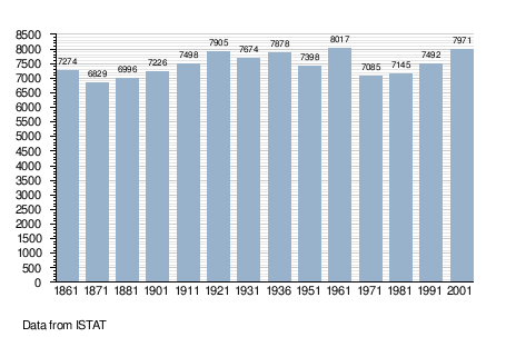
Demographic evolution