Colorado State Highway 90
| ||||
|---|---|---|---|---|
|
Map of Montrose County in western Colorado with SH 90 highlighted in red | ||||
| Route information | ||||
| Maintained by CDOT | ||||
| Length: | 41.9 mi[1] (67.4 km) | |||
| Major junctions | ||||
| West end: |
| |||
|
| ||||
| East end: |
| |||
| Location | ||||
| Counties: | Montrose | |||
| Highway system | ||||
|
Colorado State Highways
| ||||

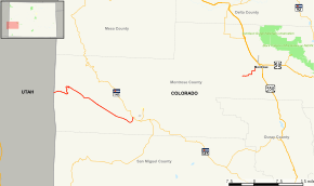
State Highway 90 is a 41.9 mi (67.4 km) long state highway at the western edge of Colorado.
Route description
SH 90 begins in the west at the border with Utah where it becomes Utah State Route 46 which continues westward to meet U.S. Highway 191 about twenty miles (32 km) south of Moab, UT. From the Utah border the road passes eastward for about 34 miles (55 km) through a very remote area, first along a section of La Sal Creek, then over a pass and though Paradox Valley, where it crosses the Dolores River Bridge near the town of Bedrock. After leaving the valley, it joins up with State Highway 141 at Vancorum where this portion of the road ends. The road then reappears approximately eight miles west of Montrose and travels into downtown Montrose where its western end occurs at its intersection with U.S. Highway 550. The two sections of the road are joined by a 49-mile (79 km) section composed mostly of unpaved road and a brief stretch of SH 141 neither of which are officially part of SH 90. Thus the official length of the road is 41.9 miles (67.4 km), but driving from one end to the other will require traveling at least 89 miles (143 km). If only paved routes are used, that distance increases considerably.
History
The route was established in the 1920s without the current gap. In 1954, all was cut out except the current eastern section, and the current western section was added back in 1963. The route was also entirely paved by 1963.[2]
Major intersections
The entire route is in Montrose County.
| Location | mi[1] | km | Destinations | Notes | |||
|---|---|---|---|---|---|---|---|
| | 0.000 | 0.000 | Continuation beyond Utah state line; West end of western segment | ||||
| Vancorum | 33.874 | 54.515 | East end of western segment | ||||
| Gap in route | |||||||
| | 81.533 | 131.215 | CR 59 / CR 90 | West end of eastern segment | |||
| Montrose | 89.858 | 144.612 | East end of eastern segment | ||||
| 1.000 mi = 1.609 km; 1.000 km = 0.621 mi | |||||||
References
- 1 2 "Segment Descriptions for Highway 90". Colorado Department of Transportation. Retrieved 2008-03-25.
- ↑ Salek, Matthew E. "Colorado Routes 80-99". Retrieved 04-11-2010. Check date values in:
|access-date=(help)