Colonial Annapolis Historic District
|
Colonial Annapolis Historic District | |
|
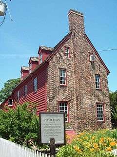
Shiplap House, Colonial Annapolis Historic District, July 2009 | |
  | |
| Location |
District boundaries approximate city boundaries surveyed in 1695, (original) Roughly bounded by Spa Creek, Southgate Ave., Hanover and West Sts.,(increase) Annapolis, Maryland |
|---|---|
| Coordinates | 38°58′41″N 76°29′29″W / 38.97806°N 76.49139°WCoordinates: 38°58′41″N 76°29′29″W / 38.97806°N 76.49139°W |
| Built | 1695 |
| Architect | Multiple |
| Architectural style |
Late Victorian, Colonial, Georgian (original) Early Republic, Late Victorian, Colonial (increase) |
| NRHP Reference # |
66000383 (original) 84003875[1] |
| Significant dates | |
| Added to NRHP |
October 15, 1966 (original) September 29, 1984 (increase)[1] |
| Designated NHLD | June 23, 1965[2] |
The Colonial Annapolis Historic District is a historic district in the City of Annapolis, the state capital of Maryland, that was created as a National Historic Landmark in 1965 and was geographically further expanded in 1984.
Annapolis has served as the capital of both the Colony/Province and the State, along with being the county seat of Maryland's third county, Anne Arundel County, and is one of the first planned cities in colonial America. Many elements of the original town plan, surveyed in 1695, and about 120 of the 18th century buildings still remain. Along with its neighboring capital city to the south of Williamsburg of the Province/Colony of Virginia and the first years of the independent Commonwealth of Virginia, both towns serve as a "living microcosm" of the 1700s and early 1800s in the United States.[2]
In terms of individually listed National Historic Landmarks and other sites on the National Register of Historic Places, the original historic colonial-era area includes the Maryland State House on State Circle, St. Ann's Church (Anglican/Episcopal) on neighboring adjacent Church Circle, and the historic residences, townhouses and some larger mansions of the town's wealthiest and most influential citizens of the Hammond-Harwood House and the Paca House and Gardens, the increase also includes the Artisan's House, Brice House, John Callahan House, and the Chase-Lloyd House.
Most of the downtown and harbor waterfront areas were declared a National Historic Landmark in 1965.[2][3]
The location of acclaimed national educational schools such as the St. John's College, (elevated to collegiate status in 1784, founded as "King William's School" in 1696) with its historic red-brick Colonial/Georgian and Federal-styled buildings (including the former colonial Governor's Mansion, begun in 1742, later used as McDowell Hall, the primary college structure) and the 1845 establishment of the United States Naval School, the nation's second-oldest military college, (later renamed the U.S. Naval Academy) with its late 19th Century French-styled architecture of Second Empire waterfront campus on the site of old Fort Severn from the War of 1812-era facing the Severn River, provide a sophisticated air to the downtown streets adding the casually attired college students and white-uniformed naval midshipmen walking about amidst the rows of brick townhouses and wood-frame homes.
With the establishment of the Historic Annapolis Foundation, as well as Annapolis Historic District Design Guidelines for New Construction, written by Robert Lamb Hart of Hart Howerton,[4] the future of the city's historical heritage of the Colonial and Federal eras with its Georgian and Federal period with its unique architecture was assured of a constant "watchdog" over any future abuses and neglect as occasionally occurred during the quiet years of the 19th and early 20th Centuries.
The Colonial Annapolis Maritime Trail System is a part of the East Coast Greenway.
References
- 1 2 National Park Service (2008-04-15). "National Register Information System". National Register of Historic Places. National Park Service.
- 1 2 3 "Colonial Annapolis Historic District". National Historic Landmark summary listing. National Park Service. Archived from the original on 2007-02-11. Retrieved 2008-06-12.
- ↑ Patricia Heintzelman; Charles D. McCormick; Joseph Watterson; D. Peter Myers (July 30, 1974). "National Register of Historic Places Inventory-Nomination: Colonial Annapolis Historic District" (pdf). National Park Service. (includes Addendum, February 1, 1983) and Sands House, and Jennings-Brice House / John Brice II House, and Maryland Inn, and Annapolis Post Office, and Donaldson-Steuart House / Kentish Inn; Anthony Workman House, and 77 Main Street / Site of Victualling House; George & John Barber's Store, and Masonic Temple / Lloyd Dulaney (or Dulaney) House, and two drawings) and Accompanying photo set of 125 pages of photos and credits, including photos from c.1950, 1961, 1964, 1965, 1968, 1971, 1972, 1974, and 1982 (32 KB)
- ↑ Robert Lamb Hart-Architects and Planners, N. Y. (1978-01-01). Annapolis Historic District Design Guidelines for New Construction. Annapolis, Maryland: The Annapolis Historic District Commission.
External links
- Colonial Annapolis Historic District, Anne Arundel County, including photo in 1982, at Maryland Historical Trust
- [Numerous photo sets available by searching on "Annapolis MD" here], at Historic American Buildings Survey
| Topics |  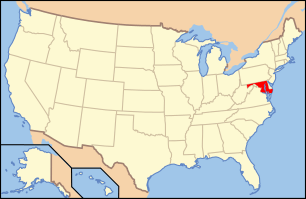 | |
|---|---|---|
| Lists by county | ||
| Lists by city | ||
| Other lists | ||
| ||