Collaroy, New South Wales
| Collaroy Sydney, New South Wales | |||||||||||||
|---|---|---|---|---|---|---|---|---|---|---|---|---|---|
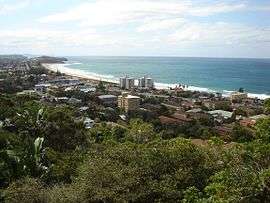 A view of Collaroy from Collaroy Plateau | |||||||||||||
| Population | 14,388 (2011 census)[1] | ||||||||||||
| Postcode(s) | 2097 | ||||||||||||
| Location | 22 km (14 mi) north-east of Sydney CBD | ||||||||||||
| LGA(s) | Northern Beaches Council | ||||||||||||
| State electorate(s) | Wakehurst | ||||||||||||
| Federal Division(s) | Mackellar | ||||||||||||
| |||||||||||||
Collaroy is a suburb in northern Sydney, in the state of New South Wales, Australia. Collaroy is 22 kilometres north-east of the Sydney central business district, in the local government area of Northern Beaches Council. It is part of the Northern Beaches region.
History
This area was originally part of Narrabeen but was renamed after the collier S.S. Collaroy ran aground on the beach in 1881 during a storm.[2][3] It was refloated and later wrecked on the Californian coast in 1889.[4] Most of Collaroy’s development has occurred since the mid twentieth century.
Collaroy Beach Post Office opened on 12 February 1923. Collaroy Plateau Post Office opened on 1 April 1949 and closed in 1988. Collaroy Plateau West Post Office opened on 1 November 1967 and was renamed Collaroy Plateau in 1996.[5]
The beach and housing near the beach on Pittwater Road were badly affected by weather in early June 2016. A strip of houses lost backyards and were left in danger of collapse.[6]
Landmarks
Collaroy’s surf beach joins Narrabeen Beach at Wetherill Street making one continuous 3.4 km surf beach. Four Surf Lifesaving Clubs provide swimming supervision/surf rescue services (North Narrabeen SLC, Narrabeen SLC, South Narrabeen SLC, and Collaroy SLC).
Collaroy is home to one of the Salvation Army's largest conference and outdoor education centres in the area. The centre caters for many conferences of the Salvation Army as well as other churches, schools, community groups and businesses. It can cater for up to 440 people and has fully catered camp programs.
Demographics
According to the 2011 census, there were 14,388 residents in Collaroy. The most common ancestries in Collaroy were English 29.5%, Australian 27.2% and Irish 8.8%. The most common responses for religion in Collaroy were Catholic 30.6%, Anglican 25.5% and No Religion 20.8%.[1]
Commercial area
Collaroy's shopping precinct is centred along Pittwater Road, which runs north-south through the suburb. Small retail businesses include cafes, restaurants, takeaway bars, a pharmacy, a newsagent/post office, several hairdressers, a day spa, a YHA youth hostel, real estate agents, Collaroy cinema, the Collaroy Services club (also known as "The Beach Club") and "The Collaroy", which was formerly known as the Surf Rock Hotel, re-opened in November 2014.[7]
Transport
Collaroy's public transport consists of buses operated by Sydney Buses south through to the CBD, Manly, North Sydney (peak hour services only), and north to the suburbs from Narrabeen to Palm Beach.
Governance
Collaroy is in the federal seat of Mackellar. The seat is currently held by Jason Falinski of the Liberal Party. The seat has been held continuously by the Liberal Party since its creation in 1949.
Collaroy is in the NSW state electorate of Wakehurst, a seat held by Brad Hazzard of the Liberal Party.[8]
Wildlife
Collaroy/Narrabeen is frequented by diverse bird and aquatic animal life including Sea Eagles, Pelicans, Terns, Ducks, Yellow-crested Cockatoo. Dolphins and whales can be seen during migrating season. In 2005 a young New Zealand Fur Seal was discovered washed up on the beach. Exhausted but alive, the Seal was nursed back to health by wildlife officers and then released. A similar incident, with another New Zealand fur seal coming ashore, occurred in August 2014.[9]
References
- 1 2 Australian Bureau of Statistics (31 October 2012). "Collaroy (State Suburb)". 2011 Census QuickStats. Retrieved 30 April 2013.
- ↑ NSW Heritage Office
- ↑ http://manly-daily.whereilive.com.au/property/story/urban-beach-retreat/
- ↑ The Book of Sydney Suburbs, Compiled by Frances Pollon, Angus & Robertson Publishers, 1990, Published in Australia ISBN 0-207-14495-8, page 66
- ↑ Premier Postal History. "Post Office List". Premier Postal Auctions. Retrieved 12 June 2012.
- ↑ "Months of misery ahead for Collaroy homeowners". News.Com.Au. News Limited. 9 June 2016. Retrieved 9 June 2016.
- ↑
- ↑ nsw.gov.au
- ↑ http://www.dailytelegraph.com.au/newslocal/northern-beaches/new-zealand-fur-seal-takes-a-break-after-stormy-weather/story-fngr8hax-1227030866942
External links
| Wikimedia Commons has media related to Collaroy, New South Wales. |
Coordinates: 33°43′48″S 151°18′00″E / 33.730°S 151.300°E