Coevorden
| Coevorden | |||
|---|---|---|---|
| City and municipality | |||
|
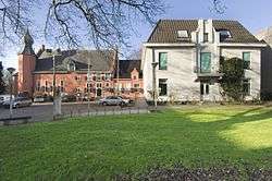
Castle and city hall of Coevorden in 2007 | |||
| |||
.svg.png) Location in Drenthe | |||
| Coordinates: 52°40′N 6°45′E / 52.667°N 6.750°ECoordinates: 52°40′N 6°45′E / 52.667°N 6.750°E | |||
| Country | Netherlands | ||
| Province | Drenthe | ||
| Government[1] | |||
| • Body | Municipal council | ||
| • Mayor | Bert Bouwmeester (D66) | ||
| Area[2] | |||
| • Total | 299.69 km2 (115.71 sq mi) | ||
| • Land | 296.54 km2 (114.49 sq mi) | ||
| • Water | 3.15 km2 (1.22 sq mi) | ||
| Elevation[3] | 12 m (39 ft) | ||
| Population (May 2014)[4] | |||
| • Total | 35,639 | ||
| • Density | 120/km2 (300/sq mi) | ||
| Demonym(s) | Coevordenaar | ||
| Time zone | CET (UTC+1) | ||
| • Summer (DST) | CEST (UTC+2) | ||
| Postcode | 7740–7759, 7840–7869 | ||
| Area code | 0524, 0528, 0591 | ||
| Website |
www | ||

Coevorden (Dutch pronunciation: [ˈkuvɔrdən]; Dutch Low Saxon: Koevern) is a municipality and a city in the northeastern Netherlands. During the municipal reorganisation in the province in 1998, Coevorden merged with Dalen, Sleen, Oosterhesselen and Zweeloo.
Etymology
The name Coevorden means "cow ford(s)" or "cow crossing", similar to Bosporus or Oxford.[5]
History
Coevorden received city rights in 1408.
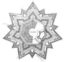
The city was captured from the Spanish in 1592 by a Dutch and English force under the command of Maurice, Prince of Orange. Coevorden was then reconstructed in the early seventeenth century to an ideal city design, similar to Palmanova. The streets were laid out in a radial pattern within polygonal fortifications and extensive outer earthworks.
The city of Coevorden may have indirectly given its name to the city of Vancouver, which is named after the 18th-century British explorer George Vancouver. The explorer's ancestors (and family name) may have originally come to England "from Coevorden" (van Coevorden > Vancoevorden > Vancouver).[5] There is also a family of nobility with the surname van Coeverden, sometimes spelled with a K (as with Canadian kayaker Adam van Koeverden).
Geography
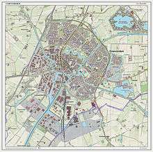
Coervorden is located at 52°40′N 6°45′E / 52.667°N 6.750°E in the south of the province of Drenthe in the east of the Netherlands.
The population centres in the municipality are:
- Aalden
- Achterste Erm
- Ballast
- Benneveld
- Bovensteenwijksmoer
- Coevorden
- Dalen
- Dalerpeel
- Dalerveen
- De Bente
- De Haar
- De Kiel
- De Mars
- Den Hool
- Diphoorn
- Eldijk
- Erm
- Gees
- Geesbrug
- Grevenberg
- 't Haantje
- Holsloot
- Hoogehaar
- Kibbelveen
- Klooster
- Langerak
- Meppen
- Nieuwe Krim
- Nieuwlande
- Noord-Sleen
- Oosterhesselen
- Padhuis
- Pikveld
- Schimmelarij
- Schoonoord
- Sleen
- Steenwijksmoer
- Stieltjeskanaal
- Valsteeg
- Veenhuizen
- Vlieghuis
- Vossebelt
- Wachtum
- Weijerswold
- Wezup
- Wezuperbrug
- Zweeloo
- Zwinderen
International relations
Coevorden is twinned with:
Transportation
There is one railway station in the municipality:
See also
Fantasy Gardens's Coevorden Castle was donated by Coevorden to Expo 86 and later relocated to the current site.
References
- ↑ "Burgemeester en wethouders" [Mayor and aldermen] (in Dutch). Gemeente Coevorden. Retrieved 6 October 2013.
- ↑ "Kerncijfers wijken en buurten" [Key figures for neighbourhoods]. CBS Statline (in Dutch). CBS. 2 July 2013. Retrieved 12 March 2014.
- ↑ "Postcodetool for 7741GC". Actueel Hoogtebestand Nederland (in Dutch). Het Waterschapshuis. Retrieved 6 October 2013.
- ↑ "Bevolkingsontwikkeling; regio per maand" [Population growth; regions per month]. CBS Statline (in Dutch). CBS. 26 June 2014. Retrieved 24 July 2014.
- 1 2 "History of Vancouver - Coevorden". Vancouverhistory.ca. Retrieved 2013-03-26.
- ↑ "Embassy of the Republic of Belarus in the Kingdom of the Netherlands - News of the Embassy". Netherlands.mfa.gov.by. 2011-05-16. Retrieved 2013-03-26.
External links
| Wikivoyage has a travel guide for Coevorden. |
| Wikimedia Commons has media related to Coevorden. |
 |
Midden-Drenthe | Aa en Hunze | Borger-Odoorn | |
| Hoogeveen | |
Emmen | ||
| ||||
| | ||||
| Hardenberg (OV) | Emlichheim (DE-NI) |
Municipalities of Drenthe | ||
|---|---|---|
 | ||
| ||