Coconut Grove
| Coconut Grove | |
|---|---|
| Neighborhood of Miami | |
|
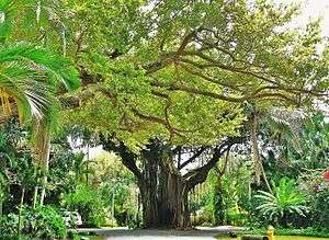
Typical street in the Grove, showing heavy vegetation characteristic of the hammock. | |
| Nickname(s): The Grove | |
 Coconut Grove neighborhood in Miami | |
| Coordinates: 25°43′N 80°15′W / 25.717°N 80.250°W | |
| Country | United States |
| State | Florida |
| County | Miami-Dade County |
| City | Miami |
| Settled | 1825 |
| Annexed into the City of Miami | 1925 |
| Subdistricts of Coconut Grove |
Neighborhoods list
|
| Government | |
| • City of Miami Commissioner | Ken Russell |
| • Miami-Dade Commissioners | Xavier L. Suarez |
| • House of Representatives | José Javier Rodríguez (Florida) (D) |
| • State Senate | Gwen Margolis (D) |
| • U.S. House | Ileana Ros-Lehtinen (R) |
| Area | |
| • Total | 5.607 sq mi (14.52 km2) |
| Elevation | 13 ft (4 m) |
| Highest elevation | 24 ft (7 m) |
| Population (2010) | |
| • Total | 20,076 |
| • Density | 8,006/sq mi (3,091/km2) |
| • Demonym | Grovite |
| Time zone | EST (UTC-05) |
| ZIP Code | 33133 |
| Area code(s) | 305, 786 |
| Website | Coconut Grove neighborhood |
Coconut Grove is the oldest continuously inhabited neighborhood of Miami in Miami-Dade County, Florida, United States. The neighborhood is roughly bound by North Prospect Drive to the south, LeJeune Road to the west, South Dixie Highway (US 1) and Rickenbacker Causeway to the north, and Biscayne Bay to the east.[1] It is south of the neighborhoods of Brickell and The Roads and east of Coral Gables. The neighborhood's name has been sometimes spelled "Cocoanut Grove" but the definitive spelling "Coconut Grove" was established when the city was incorporated in 1919.[2]
What is today referred to as Coconut Grove was formed in 1925 when the city of Miami annexed two areas of about equal size, the city of Coconut Grove and most of the town of Silver Bluff. Coconut Grove approximately corresponds to the same area as the 33133 ZIP Code although the ZIP Code includes parts of Coral Way and Coral Gables[3] and a small portion of ZIP Code 33129.[4] The area is often referred to as "The Grove" and many locals take pride that Coconut Grove is one of the greenest areas of Miami.[5][6]
Coconut Grove is directly served by the Miami Metrorail at Coconut Grove and Douglas Road stations.
History
Several waves of immigration established Coconut Grove, the first in 1825, when the Cape Florida lighthouse went into operation and was manned by John Dubose. Dr. Horace P. Porter is credited for coming up with the name when in 1873 he rented a home from Edmond D. Beasley’s widow, who homesteaded 160 acres of bay front property. He lived there for only a year but during that time he established a post office which he named Coconut Grove.[7][8] Around the same time the area saw an influx of Americans from the Northeastern US, as well as British and white Bahamian immigrants. The first hotel on the South Florida mainland was located in Coconut Grove. Called the Bay View Inn (later known as the Peacock Inn), it was built in 1882, on the site of present-day Peacock Park, by English immigrants Isabella and Charles Peacock, who had been the owner of a wholesale meat business in London. Coconut Grove's first black settlement, in the 1880s, was established by Bahamian laborers who worked at the Peacock Inn.[9] The Barnacle Historic State Park is the oldest house in Miami-Dade County still standing in its original location. It was built in 1891 and was home to Ralph Middleton Munroe, also known as "The Commodore" for being the first commodore and founder of the Biscayne Bay Yacht Club, an American yacht designer and early resident of Coconut Grove.
Formerly an independent city, Coconut Grove was annexed by the city of Miami in 1925.[10] In the 1960s, bay-shore Coconut Grove served as the center of South Florida's youth countercultural movement, notably hosting several love-ins[11] and concerts (including a now-infamous Doors concert at Dinner Key Auditorium)[12] during the latter part of the decade.[13]
Economy

Coconut Grove has a number of outdoor festivals and events, the most prominent of which is the annual Coconut Grove Arts Festival.[14] Others include the King Mango Strut, which began as a parody of the Orange Bowl Parade, and which continues each year on the last Sunday in December. The Great Taste of the Grove Food & Wine Festival takes place each April. Each June, the Goombay Festival transforms Grand Avenue in Coconut Grove into a Carnaval (Caribbean Carnival), celebrating Bahamian culture, with Bahamian food and Caribbean music (Junkanoo).
The Grove has numerous restaurants, open air and streetside cafes, and several waterfront restaurants and bars. By night, the Grove becomes a center of nightlife frequented by locals, young professionals, students from the-nearby University of Miami and Florida International University, and tourists.
Shopping is abundant in the Grove, with two open-air malls, CocoWalk, the Streets of Mayfair, and many other street shops and boutiques.
The Village Center, the three blocks radiating from and focusing on the intersection of Main, McFarland, and Grand Avenues, home to the majority of the retail and restaurant business in the Grove, is also home to three gyms, a multiplex movie house in CocoWalk, several parking garages, a state historic site, an elementary school, a City of Miami fire station, several large condos and residential rental towers, the Coconut Grove Post Office, and two sizable parks. Development and redevelopment continue to redefine and transform the area.
Major corporations including Arquitectonica, Spanish Broadcasting System, and Watsco are located in the Grove.
The eastern border of Coconut Grove is Biscayne Bay, which lends itself to the local boating and sailing communities. The area features the Coconut Grove Sailing Club, Coral Reef Yacht Club, and a sizable municipal marina, Dinner Key Marina.[15] The US Sailing Center[16] is on the Bay between Kennedy Park and the Coral Reef Yacht Club. Pan Am's seaplane operations were based at Dinner Key, and the Miami City Hall is based in the old Pan Am terminal building.
Demographics
Demographically, Coconut Grove is split up into "Northeast Coconut Grove" and "Southwest Coconut Grove", and as of 2000, the total population of both of the neighborhood's sections made up between 18,953[17] and 19,646 people.[4] The zip codes for all of Coconut Grove include 33129 and 33133. The area covers 5.607 square miles (14.52 km2). As of 2000, there were 9,695 males and 9,951 females. The median age for males were 38.4 years old, while the median age for females were 40.3 years old. The average household size had 2.1 people, while the average family size had 2.8 members. The percentage of married-couple families (among all households) was 33.6%, while the percentage of married-couple families with children (among all households) was 11.1%, and the percentage of single-mother households (among all households) was 7.6%. The percentage of never-married males 15 years old and over was 18.3%, while the percentage of never-married females 15 years old and over was 14.3%.[4] The percentage of people that speak English not well or not at all made up 8.1% of the population. The percentage of residents born in Florida was 31.6%, the percentage of people born in another U.S. state was 34.7%, and the percentage of native residents but born outside the U.S. was 2.3%, while the percentage of foreign born residents was 31.4%.[4]
As of 2000,[17] Northeast Grove had a population of 9,812 residents, with 5,113 households, and 2,221 families residing in the neighborhood. The median household income was $63,617.82. The racial makeup of the neighborhood was 35.24% Hispanic or Latino of any race, 2.25% Black or African American, 60.96% White (non-Hispanic), and 1.55% other races (non-Hispanic).
As of 2000,[17] Southwest Grove had a population of 9,141 residents, with 3,477 households, and 2,082 families residing in the neighborhood. The median household income was $63,617.82. The racial makeup of the neighborhood was 14.80% Hispanic or Latino of any race, 48.27% Black or African American, 35.27% White (non-Hispanic), and 1.66% other races (non-Hispanic).
The "West" Grove is predominantly composed of people who are of Afro-Caribbean descent. Bahamian sailors were one of the first groups of settlers in the area.[18] The Goombay festival is a celebration of the rich history of this historically Black neighborhood.[19]
Transportation
Coconut Grove is served by Metrobus throughout the area, and by the Miami Metrorail at:
- Vizcaya (SW 32nd Road and U.S. 1)
- Coconut Grove (SW 27th Avenue and U.S. 1)
- Douglas Road (SW 37th Avenue and U.S. 1)
Metrobus' Coconut Grove Connection connects at Coconut Grove and Douglas Road stations, going to many popular areas within the Grove, including CocoWalk and Peacock Park.
Education and institutions
Cultural institutions

- Coconut Grove Playhouse
- Grave of Eva Amelia Munroe, dated 1882 and adjacent to the Coconut Grove Library, it is the oldest marked grave in Miami-Dade County
- Mariah Brown House
- Marjory Stoneman Douglas Home
- Miami Science Museum, moved to downtown Miami
- Mutiny Club
- The Barnacle Historic State Park
- The Kampong
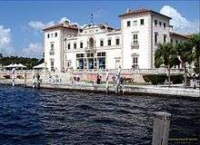
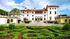
- Vizcaya Museum and Gardens
Libraries
- Coconut Grove Library, founded in 1895 by the Pine Needles Club, a literary group
- Miami-Dade Public Library operates area public libraries
- Virrick Park Library
Schools
Elementary schools
Miami-Dade County Public Schools operates area public schools:
- Coconut Grove Elementary School
- Dade County Training School (1899–1937)
- Frances S. Tucker Elementary School
- George W. Carver Elementary School
Middle schools
- George Washington Carver, while actually in Coral Gables, serves Coconut Grove
High schools
- Bridgeprep Academy of Arts and Minds Charter High School, founded in 2003
- George Washington Carver Senior High School (1937–1966)
Private schools
- Ransom Everglades School, founded in 1903
- St. Hugh Catholic School, 1956
- Immaculata-Lasalle High School, 1958
- St. Stephen's Episcopal Day School, 1958
- Carrollton School of the Sacred Heart, 1961
- Coconut Grove Montessori School
- Vanguard School
Points of interest

- Charles Avenue
- CocoWalk
- Dinner Key
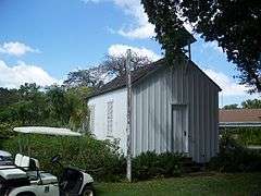
- First Coconut Grove School
- Mercy Hospital
- Miami City Hall
- Plymouth Congregational Church
- Trapp Homestead
- Woman's Club of Coconut Grove
- Grove Isle
Parks

Source:[20]
- The Kampong: an 8-acre (32,000 m2) tropical garden that forms part of the National Tropical Botanical Garden
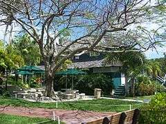
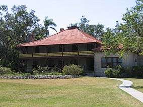
- The Barnacle Historic State Park: Built in the late 19th century, the former home of Ralph Middleton Munroe is the oldest home in Miami-Dade County still standing in its original location and is situated on the shore of Biscayne Bay. The forest surrounding the home is tropical hardwood hammock and is the last of its kind in the area. The unique architecture includes period furniture and wide porches that afford magnificent views.
- Peacock Park / Kenneth Myers Bayside Park
- David Kennedy Park
- Merrie Christmas Park
- Steele Park
- Blanche Park
- Elizabeth Virrick Park
- Kirk Munroe Park
- Coconut Grove Park
- Grand Avenue Park
- Ingraham Terrace Park
- Sunrise Park
- Marjory Stoneman Douglas Mini Park
- Dinner Key Picnic Islands Park
- Alice C. Wainwright Park
In popular culture

- The movie Where the Pavement Ends was filmed in Coconut Grove in 1923. It was directed by Rex Ingram and starred Ramón Novarro.[21]
- Pioneer folk rock musician Fred Neil resided in, and wrote songs about Coconut Grove, notably on the song "Bleecker & MacDougal".
- "Coconut Grove" is a song written by John Sebastian and recorded by The Lovin' Spoonful in 1967. It later was covered by David Lee Roth and Paul Weller. Smiths guitarist Johnny Marr has expressed a fondness for the song.
- In the film Scarface, Manny lives in an upscale home in the Grove.
- In the TV series Dexter, based on the book series by Jeff Lindsay, Dexter Morgan lives in Coconut Grove.
- In the video for the song "Careless Whisper" George Michael can be seen looking out at sea from a hotel balcony in Coconut Grove as a seaplane flies by.
- In the 1980 song "American Dream" by the (Nitty Gritty) Dirt Band, Coconut Grove is mentioned prominently in the chorus as a vacation destination.
- In the movie Bad Boys, Martin Lawrence and Will Smith follow a suspect through Coconut Grove.
- In Dave Barry's novel Big Trouble, the main setting is Coconut Grove.
- A set for the TV series Burn Notice was in Coconut Grove, in what was once the City of Miami's Convention Center.[22]
- Coconut Grove is the setting for the movie Meet The Fockers.
- Coconut Grove has been a location on the show The First 48.
- Coconut Grove is a location in the 1985 Burt Reynolds film Stick.
- The 2008 film Marley & Me with Jennifer Aniston and Owen Wilson, based on John Grogan's book, was filmed on location in Coconut Grove.
- CSI: Miami season 4 episode 10 ("Shattered") is set in Coconut Grove.
- In the first episode of The Golden Girls, "The Engagement", at the end of the episode, Rose asks Dorothy and Blanche if they would like to go to Coconut Grove for lunch, to celebrate their friendship.
Notable people
Former and current residents include:
|
|
Historic Coconut Grove
Established in 1825, Coconut Grove is one of Miami's oldest neighborhoods. As such, many of Miami's oldest buildings and homes are located in the Grove. Some of these include:
|


References
- ↑ City of Miami official map
- ↑ Blackman, E. V. Miami and Dade County, Florida. Washington, D.C.: Victor Rainbolt, 1921.
- ↑ USNaviguide.com
- 1 2 3 4 "Demographics of Coconut Grove, Miami, Florida.". city-data. Retrieved 2009-08-30.
- ↑ http://www.academia.edu/26538827/Coconut_Grove_West_Grove_tree_canopy_variations_over_time Miami’s Coconut Grove – tree canopy variation over time, May 2016, Accessed 1 October 2016
- ↑ http://milliontrees.miamidade.gov/library/miami-dade_utc-assessment_final-lr.pdf Miami-Dade Urban Tree Canopy Assessment 2016
- ↑ "City of Miami – Neighborhood Enhancement Teams". Retrieved 2011-10-14.
- ↑ Planning Your Vacation in Florida, Miami and Dade County [WPA Guide to Miami], Northport, New York: Bacon, Percy & Daggett, 1941, page 49.
- ↑ Joanne Hyppolite. Black Crossroads. South Florida History, the magazine of the Historical Museum of Southern Florida. Volume 37, No 1, 2009, p. 13
- ↑ Livingston, Grant (2000). "The Annexation of the City of Coconut Grove" (PDF). Tequesta. Miami, Florida: Historical Association of Southern Florida. LX: 32–55. ISSN 0363-3705. Retrieved 2008-12-11.
- ↑ Bjebre, Bill; Kenneth Harrell (September 8, 1969). "Grove "Love-In" Swings Under Eyes of Police". The Miami News. Retrieved March 26, 2011.
- ↑ Art Grace (March 11, 1969). "In Defense of a Generation: 'Hippies are Beautiful'". The Miami News. Retrieved April 29, 2011.
- ↑ Woodman, Jim (July 23, 1972). "Coconut Grove: Hip Little Village Under the Palms". Chicago Tribune. Retrieved March 26, 2011.
- ↑ "website of Coconut Grove Arts Festival". Retrieved September 25, 2012.
- ↑ CMS Redirect<!- - Bot generated title -->
- ↑ US Sailing Center
- 1 2 3 "Demographics of Coconut Grove Miami, Florida.". miamigov.com. Retrieved 2008-06-11.
- ↑ Samantha Joseph (July 7, 2004). "Western Coconut Grove leaders eye revitalization". Miami Today. Retrieved March 16, 2010.
- ↑ "Miami Goombay Festival". Greater Miami Convention and Visitors Bureau. Retrieved March 16, 2010.
- ↑ "City of Miami Parks Department list". Retrieved September 27, 2010.
- ↑ Planning Your Vacation in Florida, Miami and Dade County [WPA Guide to Miami], Northport, New York: Bacon, Percy & Daggett, 1941, p. 145.
- ↑ "Burn Notice is up for sale!" http://coconutgrovegrapevine.blogspot.com/2013/08/burn-notice-is-up-for-sale.html
- ↑ "Obituary". The New York Times. August 24, 2001. Retrieved February 16, 2011.
- ↑ "Astronaut Bio". NASA.gov. Retrieved February 13, 2011.
- ↑ Kleinberg, Howard (2003). The Stingaree Century. (self published). ISBN 0974158909.
External links
| Wikimedia Commons has media related to Coconut Grove, Florida. |
-
 Coconut Grove travel guide from Wikivoyage
 - City of Miami neighborhoods map
- Coconut Grove Grapevine (daily news of the Grove)
- The case of Joyce Cohen
Coordinates: 25°43′N 80°15′W / 25.717°N 80.250°W