Cochrane Dam
Not to be confused with Cochrane Dam (New South Wales).
| Cochrane Dam | |
|---|---|
 Location of Cochrane Dam in Montana | |
| Country | United States of America |
| Location | Cascade County, Montana |
| Coordinates | 47°33′11″N 111°08′56″W / 47.55306°N 111.14889°WCoordinates: 47°33′11″N 111°08′56″W / 47.55306°N 111.14889°W |
| Status | In use |
| Opening date | 1958 |
| Owner(s) | NorthWestern Corporation |
| Dam and spillways | |
| Type of dam | Concrete gravity |
| Impounds | Missouri River |
| Height | 59 ft (18 m) |
| Length | 753 ft (230 m) |
| Spillways | 1 |
| Spillway type | Gated service |
| Reservoir | |
| Creates | Cochrane Lake |
| Total capacity | 2,700 acre·ft (3,300,000 m3) |
| Catchment area | 24,000 sq mi (62,000 km2) |
| Surface area | 218 acres (88 ha) |
| Power station | |
| Turbines | 2 |
| Installed capacity | 64 MW |
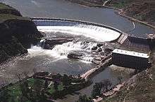
Cochrane Dam is a run-of-the river hydroelectric dam on the Missouri River, about 8 miles (13 km) northeast of Great Falls in the U.S. state of Montana.[1] The dam has a concrete gravity design and is 59 feet (18 m) high and 753 feet (230 m) long. Its power station has two generators capable of producing 64 megawatts. Construction of the dam was finished in 1958.[2] Montana Power Company originally built the dam, PPL Corporation purchased it in 1997 and sold it to NorthWestern Corporation in 2014.
References
- ↑ "Dams". PPL Montana. Retrieved 2011-03-06.
- ↑ "Cochrane Dam". Producing Power. PPL Montana. Retrieved 2011-03-06.
Dams on the Missouri River | ||
|---|---|---|
 | ||
This article is issued from Wikipedia - version of the 12/6/2015. The text is available under the Creative Commons Attribution/Share Alike but additional terms may apply for the media files.