Coburg Historic District
|
Coburg Historic District | |
|
The 1870 stagecoach house, and later railroad station house, at the corner of McKenzie and Harrison Streets in 2011. | |
|
Map of the district boundaries, showing historic contributing buildings and resources. | |
| Location | Coburg, Oregon |
|---|---|
| Coordinates | 44°08′14″N 123°03′49″W / 44.137293°N 123.063579°WCoordinates: 44°08′14″N 123°03′49″W / 44.137293°N 123.063579°W |
| NRHP Reference # | 86000036 |
| Added to NRHP | January 7, 1986[1] |
_1870.jpg)
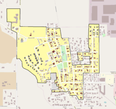
The Coburg Historic District is a National Historic District located in the city of Coburg, Oregon, United States. The district is roughly bounded by Van Duyn Road, Diamond and Miller streets, Dixon Street and Tax lots 1700 and 201, and Bottom Loop Road.
The district was placed on the National Register of Historic Places in 1986.[1] The period of significance of the district dates back to 1875.
References
- 1 2 "Oregon National Register List" (PDF). Oregon Parks and Recreation Department. June 6, 2011. p. 20. Retrieved September 28, 2013.
External links
 Media related to Coburg Historic District at Wikimedia Commons
- Information on historic homes from the City of Coburg website
This article is issued from Wikipedia - version of the 11/24/2016. The text is available under the Creative Commons Attribution/Share Alike but additional terms may apply for the media files.