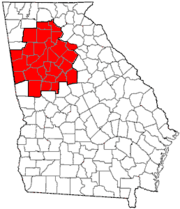
Cobb County, Georgia
| Cobb County, Georgia | ||
|---|---|---|
| County | ||
| Cobb County | ||
 The Cobb County Courthouse in September 2006. | ||
| ||
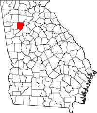 Location in the U.S. state of Georgia | ||
 Georgia's location in the U.S. | ||
| Founded | December 2, 1832 | |
| Named for | Thomas W. Cobb | |
| Seat | Marietta | |
| Largest city | Marietta | |
| Area | ||
| • Total | 345 sq mi (894 km2) | |
| • Land | 340 sq mi (881 km2) | |
| • Water | 5.0 sq mi (13 km2), 1.4% | |
| Population | ||
| • Total | 741,334 | |
| • Density | 2,026/sq mi (782/km²) | |
| Congressional districts | 6th, 11th, 13th | |
| Time zone | Eastern: UTC-5/-4 | |
| Website |
www | |

Cobb County is a suburban county in the U.S. state of Georgia. As of the 2015, the population was 741,334,[1] making it Georgia's fourth-most populous county. Its county seat and largest city is Marietta.[2]
Cobb, along with several adjoining counties, was created on December 3, 1832, by the Georgia General Assembly from the huge Cherokee "county" territory—land northwest of the Chattahoochee River which the state confiscated from the Cherokee Nation and redistributed to settlers via lottery, following the passage of the federal Indian Removal Act.[3] The county was named for Thomas Willis Cobb, a United States representative and senator from Georgia. It is believed Marietta was named for his wife, Mary.[4]
Cobb County is included in the Atlanta-Sandy Springs-Roswell, GA Metropolitan Statistical Area. It is situated immediately to the northwest of Atlanta's city limits.
Its Cumberland District, an edge city, has over 24,000,000 square feet (2,200,000 m2) of office space.
The U.S. Census Bureau ranks Cobb County as the most-educated in the state of Georgia and 12th among all counties in the United States.[5] It has ranked among the top 100 wealthiest counties in the United States.[6]
History
Cobb County was one of nine Georgia counties carved out of the disputed territory of the Cherokee Nation in 1832.[7] It was the 81st county in Georgia and named for Judge Thomas Willis Cobb, who served as a U.S. Senator, state congressman and Superior Court Judge. It is believed that the county seat of Marietta was named for Judge Cobb's wife, Mary.[8] The state started acquiring right-of-way for a railroad in 1836. A train began running between Marietta and Marthasville (now Atlanta) in 1845.[9] Before the Civil War, Marietta was a summer resort for residents of Savannah and Charleston fleeing Yellow Fever.
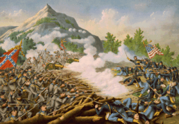
During the American Civil War, some confederate troops were trained at a camp in Kennesaw.[9] There were battles of New Hope Church May 25, Pickett's Mill May 27, and Dallas May 28. The Battle of Allatoona Pass on October 28 occurred as Sherman was starting his March through Georgia. Union forces burnt most houses and confiscated or burnt crops.[10] The Battle of Kennesaw Mountain June 27, 1864, was the site of the only major Confederate victory in General William T. Sherman's invasion of Georgia. Despite the victory, Union forces outflanked the Confederates.
In 1915, Leo Frank, the Jewish supervisor of an Atlanta pencil factory who was convicted of murdering one of his workers, thirteen-year-old Mary Phagan, was kidnapped from his jail cell and brought to Frey's Gin, two miles (3 km) east of Marietta, where he was lynched.
Cotton farming in the area peaked from the 1890s through the 1920s. Low prices during the Great Depression resulted in the cessation of cotton farming throughout Cobb County.[11] The price of Cotton went from 16 cents a pound in 1920 to 9.5 cents in 1930. This resulted in a Cotton Bust for the county, which had stopped growing the product but was milling it. This bust was in turn, followed by the Great Depression.[9][12] To help combat the bust, the state started work on a road in 1922 that would later become US 41.

In 1942, Bell Aircraft opened a Marietta plant to manufacture B-29 bombers and Marietta Army Airfield was founded. Both were closed after World War II, but reopened during the Korean War, when the air field was acquired by the Air Force, renamed Dobbins AFB, and the plant by Lockheed. During the Korean and Vietnam Wars, Lockheed Marietta was the leading manufacturer of military transport planes, including the C-130 Hercules and the C-5 Galaxy. "In Cobb County and other sprawling Cold War suburbs from Orange County to Norfolk/Hampton Roads, the direct link between federal defense spending and local economic prosperity structured a bipartisan political culture of hawkish conservatism and material self-interest on issues of national security."[13]

When home rule was enacted statewide by amendment to the Georgia state constitution in the early 1960s, Ernest W. Barrett became the first chairman of the new county commission. The county courthouse, built in 1888, was demolished.
In the 1960s and 1970s, Cobb transformed from rural to suburban, as integration spurred white flight from the city of Atlanta, which by 1970 was majority-African-American. Real estate booms drew rural white southerners and Rustbelt transplants, both groups mostly first-generation white-collar. Cobb County was the home of former segregationist and Georgia governor Lester Maddox (1966–71). In 1975, Cobb voters elected John Birch Society leader Larry McDonald to Congress, running in opposition to desegregation busing. A conservative Democrat, McDonald called for investigations into alleged plots by the Rockefellers and the Soviet Union to impose "socialist-one-world-government" and co-founded the Western Goals Foundation. In 1983, McDonald died aboard Korean airlines flight 007, shot down by a Soviet fighter over restricted airspace.

In 1990, Republican Congressmen Newt Gingrich became Representative of a new district centered around Cobb County. In 1994, as Republicans took control of the House of Representatives for the first time in almost fifty years, Gingrich became Speaker of the House, thrusting Cobb County into the national spotlight. In 1993, county commissioners passed a resolution condemning homosexuality and cut off funding for the arts after complaints about a community theater.[14] After protests from gay rights organizations, organizers of the 1996 Summer Olympics pulled events out of Cobb County. The county's inns were nevertheless filled at 100% of capacity for two months during the event.[9]
In the 1990s and 2000s, Cobb's demographics changed. As Atlanta's gentrification reversed decades of white flight, middle-class African-Americans and Russian, Bosnian, Chinese, Indian, Brazilian, Mexican and Central American immigrants moved to older suburbs in South and West Cobb. In 2010, African-American Democrat David Scott was elected to Georgia's 13th congressional district, which included many of those suburbs. Cobb became the first Georgia county to participate in the Immigration and Nationality Act Section 287(g) enabling local law officers to enforce immigration law.
Geography


According to the U.S. Census Bureau, the county has a total area of 345 square miles (890 km2), of which 340 square miles (880 km2) is land and 4.0 square miles (10 km2) (1.4%) is water.[15]
The county is divided between two major basins. Most runoff flows into the Middle Chattahoochee-Lake Harding and Upper Chattahoochee River sub-basins of the ACF River Basin (Apalachicola-Chattahoochee-Flint River Basin) along the southeastern border, directly via Willeo Creek, Sope Creek (Sewell Creek), Rottenwood Creek (Powers Creek, Poorhouse Creek, Poplar Creek), Nickajack Creek and others. The large Sweetwater Creek is the other major stream, carrying the waters of Noses Creek (Ward Creek, Olley Creek, Mud Creek), Powder Springs Creek (Rakestraw Creek, Mill Creek) and others into the Chattahoochee. A ridge from Lost Mountain in the west, to Kennesaw Mountain in the north-central, to Sweat Mountain in the extreme northeast, divides the far north-northwest of the county into the Etowah River sub-basin of the ACT River Basin (Coosa-Tallapoosa River Basin), which includes Lake Allatoona. Noonday Creek (Little Noonday Creek) flows northward into the lake, as does Allatoona Creek, which forms a major arm of the lake. Proctor Creek forms the much older Lake Acworth, which in turn empties directly into Lake Allatoona under the Lake Acworth Drive (Georgia 92) bridge. North Cobb is in the Coosa River basin.
There are several high points in Cobb County.
- Sweat Mountain: in the extreme northeast portion, runs along the border with Cherokee County, and is the metro area's major antenna farm
- Blackjack Mountain: a low ridge between central and east Cobb
- Kennesaw Mountain: the highest point in the county and in the entire suburban area of metro Atlanta, located in the north-northwest between Kennesaw and Marietta
- Little Kennesaw Mountain: an offshoot of Kennesaw
- Lost Mountain: in western Cobb
- Pine Mountain: west-northwest of Kennesaw Mountain, between Kennesaw and Due West
- Brushy Mountain: near Kennesaw Mountain, just southeast of Barrett Parkway at Cobb Parkway
- Vinings Mountain or Mount Wilkinson: overlooks the town of Vinings
Adjacent counties
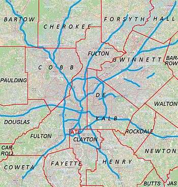
- Cherokee County – north
- Fulton County – southeast
- Douglas County – southwest
- Paulding County – west
- Bartow County – northwest
Addressing
Despite the lack of a grid system of city blocks though the county, all street addresses have their numeric origin at the southwest corner of the town square in Marietta.
Geocodes and world's largest toll-free calling area
Originally in area code 404, the county was moved into area code 770 in 1995, and overlaid by area code 678 in 1998. Prior to 1995, those with phones tied to the Woodstock telephone exchange (prefixes 924, 926, 928, later 516 and 591) could also call the Canton exchange (479, later 445, then 704) as a local call. This became moot, along with other dual-zone exchanges in metro Atlanta, when the exurban exchanges (including Canton) were fully made a part of what was already the world's largest toll-free calling zone. It is a zone spanning 7,162 square miles (18,549 km2),[16] with four active telephone area codes, and local calling extending into portions of two others.
Cobb's FIPS county code is 13067. Because the National Weather Service has not subdivided the county, its WRSAME code is 013067, for receiving targeted weather warnings from NOAA Weather Radio. The county is primarily within the broadcast range of one weather radio station: KEC80, on 162.550 MHz,[17] transmitted to all of metro Atlanta and broadcast from NWSFO Peachtree City. The secondary station is the much newer WWH23 on 162.425 from Buchanan, which also transmits warnings for Cobb but has reception mainly in the western part of the county.[18]
Demographics
| Historical population | |||
|---|---|---|---|
| Census | Pop. | %± | |
| 1840 | 7,539 | — | |
| 1850 | 13,843 | 83.6% | |
| 1860 | 14,242 | 2.9% | |
| 1870 | 13,814 | −3.0% | |
| 1880 | 20,748 | 50.2% | |
| 1890 | 22,286 | 7.4% | |
| 1900 | 24,664 | 10.7% | |
| 1910 | 28,397 | 15.1% | |
| 1920 | 30,437 | 7.2% | |
| 1930 | 35,408 | 16.3% | |
| 1940 | 38,272 | 8.1% | |
| 1950 | 61,830 | 61.6% | |
| 1960 | 114,174 | 84.7% | |
| 1970 | 196,793 | 72.4% | |
| 1980 | 297,718 | 51.3% | |
| 1990 | 447,745 | 50.4% | |
| 2000 | 607,751 | 35.7% | |
| 2010 | 688,078 | 13.2% | |
| Est. 2015 | 741,334 | [19] | 7.7% |
| U.S. Decennial Census[20] 1790-1960[21] 1900-1990[22] 1990-2000[23] 2010-2013[1] | |||
2000 census
As of 2011, there were 697,553 people, 248,303 households, and 169,178 families residing in the county. The population density was 1,998 people per square mile (763/km²). There were 261,659 housing units at an average density of 770 per square mile (301/km²). The racial makeup of the county in 2010 62.2% White, 25.0% Black,[24] 0.3% Native American, 4.5% Asian, 0.0% Pacific Islander, 5.3% from other races, and 2.7% from two or more races. 14.3% of the population was Hispanic or Latino of any race.[25]
There were 248,303 households out of which 35.80% had children under the age of 18 living with them, 54.30% were married couples living together, 10.70% had a female householder with no husband present, and 31.20% were non-families. 23.20% of all households were made up of individuals and 4.10% had someone living alone who was 65 years of age or older. The average household size was 2.71 and the average family size was 3.25.
In the county the population was spread out with 26.10% under the age of 18, 9.00% from 18 to 24, 36.50% from 25 to 44, 21.50% from 45 to 64, and 6.90% who were 65 years of age or older. The median age was 33 years. For every 100 females there were 98.50 males. For every 100 females age 18 and over, there were 95.90 males.
As of 2007, the median income was $70,472. The per capita income for the county was $32,740. About 6.0% of families and 9.4% of the population were below the poverty line, including 9.1% of those under age 18 and 7.8% of those age 65 or over.
2010 census
As of the 2010 United States Census, there were 688,078 people, 260,056 households, and 175,357 families residing in the county.[26] The population density was 2,026.4 inhabitants per square mile (782.4/km2). There were 286,490 housing units at an average density of 843.7 per square mile (325.8/km2).[27] The racial makeup of the county was 62.2% white, 25.0% black or African American, 4.5% Asian, 0.3% American Indian, 0.1% Pacific islander, 5.3% from other races, and 2.7% from two or more races. Those of Hispanic or Latino origin made up 12.3% of the population.[26] In terms of ancestry, 10.4% were German, 10.0% were English, 9.3% were Irish, and 8.6% were American.[28]
Of the 260,056 households, 36.7% had children under the age of 18 living with them, 50.2% were married couples living together, 13.0% had a female householder with no husband present, 32.6% were non-families, and 25.6% of all households were made up of individuals. The average household size was 2.61 and the average family size was 3.17. The median age was 35.4 years.[26]
The median income for a household in the county was $65,522 and the median income for a family was $78,920. Males had a median income of $55,200 versus $43,367 for females. The per capita income for the county was $33,110. About 7.6% of families and 10.6% of the population were below the poverty line, including 14.5% of those under age 18 and 7.2% of those age 65 or over.[29]
Education
Public schools
- Cobb County School District (serves all county locations except the city of Marietta)
- Marietta City Schools (serves city of Marietta locations)
Private schools
- Cumberland Christian Academy, Austell (K-12)
- Mount Paran Christian School, Kennesaw (preK-12)
- North Cobb Christian School, Kennesaw (K-12)
- Shreiner Academy, Marietta (preK-8)
- The Walker School, Marietta (preK-12)
- Whitefield Academy, Mableton (preK-12)
Colleges and universities
Libraries
Cobb County maintains the Cobb County Public Library System.[31] The libraries provide resources such as books, videos, internet access, printing, and computer classes. The libraries in the CCPLS are:
- Acworth Library
- Central Library
- East Cobb Library
- East Marietta Library
- Gritters Library
- Hattie G. Wilson Library
- Kemp Memorial Library
- Kennesaw Library
- Lewis A. Ray Library
- Mountain View Regional Library
- Powder Springs Library
- Sibley Library
- South Cobb Regional Library
- Stratton Library
- Sweetwater Valley Library
- Vinings Library
- West Cobb Regional Library
The Smyrna Public Library is a city-owned library in Smyrna.
Government and elections
Under Georgia's home rule provision, county governments have free rein to legislate on all matters within the county, provided that such legislation does not conflict with state or federal laws or constitutions.
Cobb County is governed by a five-member board of commissioners, which has both legislative and executive authority within the county. The chairman of the board is elected county-wide. The other four commissioners are elected from single-member districts. The board hires a county manager who oversees day-to-day operations of the county's executive departments.
County residents also elect a sheriff, district attorney, probate court judge, clerk of superior court, clerk of the state court, state court solicitor, chief magistrate judge (who then appoints other magistrate court judges), superior court judges, state court judges, tax commissioner, surveyor, and a seven-member board of education. In addition to the county sheriff, the constitutional chief law enforcement officer of the county, Cobb County has a separate police department under the authority of the Board of Commissioners. The sheriff oversees the jail, to which everyone arrested under state law is taken, regardless of the city or other area of the county where it happens, or what police department makes the arrest.
Each city has a separate police department, answerable to its governing council. Marietta, Smyrna, and Austell have separate fire departments, with the Cobb County Fire Department being the authority having jurisdiction over Kennesaw, Acworth, Powder Springs, and unincorporated areas. Cobb 911 covers unincorporated areas and the cities of Marietta and Powder Springs. Kennesaw and Acworth jointly operate a small 911 call center (PSAP) upstairs in Kennesaw city hall, dispatching the police departments in both cities, and forwarding fire calls to Cobb. Austell and Smyrna operate their own separate 911 systems.
The county retails potable water to much of the county, and wholesales it to various cities.[32]
The current County Manager is David Hankerson.[33]
Taxes
In addition to the 4% statewide sales tax, Cobb County levies an additional 2% for special projects, each 1% subject to separate renewal every few years by countywide referendum (including within its cities). This funds mainly transportation and parks. Cobb levies a 1% tax to lower property taxes, but only for the public school budget, and not the additional 1% HOST homestead exemption for general funds. It has also voted not to pay the extra 1% to join MARTA.
At the beginning of 2006, Cobb County became the last county in the state to raise the tax to 6%, which also doubled the tax on food to 2%. The SPLOST barely passed by a 114 vote margin, or less than one-quarter of a percent, in a September 2005 referendum. The revenue will go to a new county courthouse, expanded jail, various transportation projects, and the purchasing of property for parks and green space.[34] In 2008, the school tax was renewed for a third term, funding the Marietta and Cobb school systems.
Economy
The Cobb County School District is Cobb County's largest employer, employing over 15,000 people.[35] Private corporations include:
- The Home Depot Atlanta Store Support Center, world headquarters[36]
- The Weather Channel headquarters[37]
- InTown Suites headquarters[38]
- Lockheed Martin Aeronautical Plant, located next to Dobbins Air Reserve Base in unincorporated Cobb.[39]
- Kool Smiles (Marietta)[40]
- Coca-Cola headquarters
- General Electric's Energy Management business headquarters
Diplomatic missions
The Consulate-General of Costa Rica in Atlanta is located in Suite 100 at 1870 The Exchange in an unincorporated section of Cobb County.[41]
Transportation

Major highways
-
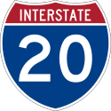 Interstate 20
 -
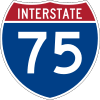 Interstate 75
 -
 Interstate 285
 -
 Interstate 575
 -
 U.S. Route 41
 -
 U.S. Route 78
 -
 U.S. Route 278
 -
 State Route 3
 -
 State Route 5
 -
 State Route 5 Connector
 -
 State Route 6
 -
 State Route 6 Business
 -
 State Route 6 Spur
 -
 State Route 8
 -
 State Route 92
 -
 State Route 120
 -
 State Route 120 Alternate
 -
 State Route 139
 -
 State Route 280
 -
 State Route 360
 -
 State Route 401 (unsigned designation for I-75)
 -
 State Route 402 (unsigned designation for I-20)
 -
 State Route 407 (unsigned designation for I-285)
 -
 State Route 417 (unsigned designation for I-575)
Airports
- Cobb County Airport at McCollum Field
- Dobbins Air Reserve Base (where the U.S. President usually arrives when visiting Atlanta)
Rail
- Norfolk Southern through Mableton, Austell railyard, Powder Springs
- CSX Transportation through Acworth, Kennesaw, Marietta, Smyrna, and Vinings
- Georgia Northeastern Railroad spur line north from Marietta
Mass transit
- Xpress GA / RTA commuter buses and Cobb Community Transit (CCT) Marietta/Cobb Counties Transit System serve the county. MARTA also has connecting bus service to the Cumberland, Georgia business district in the southeastern part of the county.
Recreation


- American Adventures (Marietta)
- Chattahoochee River National Recreation Area[42]
- Kennesaw Mountain National Battlefield Park (Kennesaw to Marietta)[43]
- Lake Acworth/Acworth Beach(Acworth)[44]
- Lake Allatoona (near Acworth)[45]
- Mable House (Mableton)[46]
- Marietta Confederate Cemetery (Marietta)[47]
- Marietta Museum of History (Marietta)[48]
- Marietta/Cobb Museum of Art (Marietta)[49]
- Marietta National Cemetery (Marietta)[50]
- Silver Comet Trail (Smyrna, Mableton, Powder Springs)[51]
- Six Flags Over Georgia (Unincorporated Cobb)
- Six Flags White Water (Marietta)
- Southern Museum of Civil War and Locomotive History (Kennesaw)[52]
- Sun Valley Beach (near Powder Springs)
Venues
- Cobb County Civic Center[53]
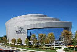
- Cobb Energy Performing Arts Center[54]
- Mable House Amphitheater[46]
- SunTrust Park[55]
Communities

Cities
Census-designated places
Unincorporated communities
- Blackwells
- Chattahoochee Plantation
- Clarkdale
- Cumberland
- Due West
- East Cobb
- Lost Mountain
- Macland
- Mars Hill
- Mount Bethel
- North East Cobb
- Noonday
- Powers Park
- Sandy Plains
- Spring Hill
- Town Center
- Westoak
Notable people
- Roy Barnes - Governor of Georgia, 1999-2003; born in Cobb County and worked there as a prosecutor[56][57]
- Bob Barr – politician; United States Representative, Republican Party; Libertarian Party candidate for President of the United States
- Big Boss Man – professional wrestler; corrections officer[58]
- Louie Giglio - pastor, author, founder of the Passion Conferences, pastor of Passion City Church in Atlanta, head of sixstepsrecords
- Tyler Perry – actor, author, screen writer and playwright, producer, director, songwriter[59]
Sister county
See also
References
- 1 2 "State & County QuickFacts". United States Census Bureau. Retrieved February 15, 2014.
- ↑ "Find a County". National Association of Counties. Archived from the original on 2011-05-31. Retrieved 2011-06-07.
- ↑ "Cobb County, Georgia".
- ↑ "New Georgia Encyclopedia: Marietta". Georgiaencyclopedia.org. 2003-09-30. Retrieved 2010-07-22.
- ↑ ACS: Ranking Table – Percent of People 25 Years and Over Who Have Completed a Bachelor's Degree
- ↑ bizjournals: How 100 counties ranked in wealth
- ↑ "New Georgia Encyclopedia: Cobb County". Georgiaencyclopedia.org. 2011-11-15. Retrieved 2012-12-22.
- ↑ "Marietta | Georgia.gov". Marietta.georgia.gov. Retrieved 2012-06-24.
- 1 2 3 4 "Cobb County, Georgia, History, Resources, Links, and Events".
- ↑ Images of Acworth Society for Historic Preservation. Charleston, SC: Arcadia Publishing. 2006. p. 7. ISBN 0-7385-1479-9.
- ↑ Images of Acworth Society for Historic Preservation. Charleston, SC: Arcadia Publishing. 2006. p. 56. ISBN 0-7385-1479-9.
- ↑ "Archived copy". Archived from the original on 2014-09-17. Retrieved 2014-09-16.
- ↑ Matthew Lassiter, "Big Government and Family Values: Political Culture in the Metropolitan Sunbelt" Pg. 90 in Sunbelt Rising: The Politics of Place, Space and Region ed. Michelle Nickerson, Darren Dochuck
- ↑ Applebome, Peter (1993-08-29). "County's Anti-Gay Move Catches Few by Surprise". The New York Times.
- ↑ "US Gazetteer files: 2010, 2000, and 1990". United States Census Bureau. 2011-02-12. Retrieved 2011-04-23.
- ↑ "A Look at Atlanta" (PDF). Metro Atlanta Chamber of Commerce. May 2006. p. 11. Archived (PDF) from the original on 2008-06-25. Retrieved 2008-07-05.
- ↑ "NOAA Weather Radio KEC80". Nws.noaa.gov. 2009-05-14. Retrieved 2010-07-22.
- ↑ "NOAA Weather Radio WWH23". Nws.noaa.gov. 2009-05-14. Retrieved 2010-07-22.
- ↑ "County Totals Dataset: Population, Population Change and Estimated Components of Population Change: April 1, 2010 to July 1, 2015". Retrieved July 2, 2016.
- ↑ "U.S. Decennial Census". United States Census Bureau. Archived from the original on May 11, 2015. Retrieved June 20, 2014.
- ↑ "Historical Census Browser". University of Virginia Library. Retrieved June 20, 2014.
- ↑ "Population of Counties by Decennial Census: 1900 to 1990". United States Census Bureau. Retrieved June 20, 2014.
- ↑ "Census 2000 PHC-T-4. Ranking Tables for Counties: 1990 and 2000" (PDF). United States Census Bureau. Retrieved June 20, 2014.
- ↑ "Cobb County QuickFacts from the US Census Bureau".
- ↑ Data Access and Dissemination Systems (DADS). "American FactFinder - Results". Archived from the original on 2016-04-17.
- 1 2 3 "DP-1 Profile of General Population and Housing Characteristics: 2010 Demographic Profile Data". United States Census Bureau. Retrieved 2015-12-27.
- ↑ "Population, Housing Units, Area, and Density: 2010 - County". United States Census Bureau. Retrieved 2015-12-27.
- ↑ "DP02 SELECTED SOCIAL CHARACTERISTICS IN THE UNITED STATES – 2006-2010 American Community Survey 5-Year Estimates". United States Census Bureau. Retrieved 2015-12-27.
- ↑ "DP03 SELECTED ECONOMIC CHARACTERISTICS – 2006-2010 American Community Survey 5-Year Estimates". United States Census Bureau. Retrieved 2015-12-27.
- ↑ Kennesaw.com. "Kennesaw State, Southern Poly to Merge". www.kennesaw.com. Retrieved 2016-03-11.
- ↑ Cobb County Public Library System Archived May 17, 2011, at the Wayback Machine.
- ↑ "Cobb County Government". Water.cobbcountyga.gov. Retrieved 2012-12-22.
- ↑ Abernathy, Kristina. "County Manager". www.cobbcounty.org. Retrieved 2016-02-03.
- ↑ "Cobb Local Sales Tax for Public Safety and Transportation". Cobbcip.org. 2005-09-20. Retrieved 2010-07-22.
- ↑ "Index". Cobb County School District. Retrieved July 28, 2009.
- ↑ "Corporate and Financial Overview." The Home Depot. Retrieved on April 24, 2009.
- ↑ "Video Submission Agreement Archived October 19, 2009, at the Wayback Machine.." The Weather Channel. Retrieved on November 18, 2009.
- ↑ "Low Weekly Rates!." InTown Suites. Retrieved on November 18, 2009.
- ↑ "New Georgia Encyclopedia: Lockheed Martin". Georgiaencyclopedia.org. Retrieved 2012-12-26.
- ↑ "Kool Smiles Main Contacts." Kool Smiles. Retrieved on January 1, 2011. "Kool Smiles Patient Support Center 1090 Northchase Pkwy SE, Ste 290 Marietta, GA 30067-6407"
- ↑ "Consulates in the United States Archived October 22, 2008, at the Wayback Machine.." Embassy of Costa Rica. Retrieved October 26, 2008.
- ↑ "Chattahoochee River National Recreation Area - Chattahoochee River National Recreation Area". Nps.gov. 2012-12-11. Retrieved 2012-12-26.
- ↑ "Kennesaw Mountain National Battlefield Park - Kennesaw Mountain National Battlefield Park". Nps.gov. 2012-08-07. Retrieved 2012-12-26.
- ↑ "Acworth Beach | Cauble Park, Acworth, Georgia". Allatoonalake.org. 2008-01-20. Retrieved 2012-12-26.
- ↑ "recreation area details - Allatoona Lake". Recreation.gov. Retrieved 2012-12-26.
- 1 2 "Arts Center". The Mable House. Retrieved 2012-12-26.
- ↑ "Confederate Cemetery, Marietta, Georgia". Roadsidegeorgia.com. Retrieved 2012-12-26.
- ↑ Home. "Marietta Museum of History » Preserving the history of Marietta and Cobb County". Mariettahistory.org. Retrieved 2012-12-26.
- ↑ "MariettaCobb Museum of Art - Marietta/Cobb Museum of Art". Mariettacobbartmuseum.org. Retrieved 2012-12-26.
- ↑ National Cemetery Administration. "Cemeteries - Marietta National Cemetery - Burial and Memorial Benefits". Cem.va.gov. Retrieved 2012-12-26.
- ↑ "Cobb County Parks, Recreation, Cultural Affairs". Prca.cobbcountyga.gov. Archived from the original on 2013-03-02. Retrieved 2012-12-26.
- ↑ "The Southern Museum of Civil War and Locomotive History". Southernmuseum.org. Retrieved 2012-12-26.
- ↑ "civic center". Prca.cobbcountyga.gov. Retrieved 2012-12-26.
- ↑ "Cobb Energy Performing Arts Centre | Cobb Energy Performing Arts Centre Atlanta, GA". Cobbenergycentre.com. Retrieved 2012-12-26.
- ↑ "Atlanta Braves announce plans to move to new stadium". USA Today.
- ↑ Cook, James F. (2005). The Governors of Georgia, 1754-2004, 3rd Edition, Revised and Expanded. Macon, GA: Mercer University Press.
- ↑ "New Georgia Encyclopedia: Roy Barnes (b. 1948)". Georgiaencyclopedia.org. Retrieved August 29, 2010.
- ↑ "Wrestling - Big Boss Man's Theme Lyrics - MetroLyrics".
- ↑ sheree r curry (23 August 2010). "Tyler Perry Buys $40M Atlanta Mansion as $7.6M Teardown". AOL Real Estate Blog.
- ↑ "Cobb County Delegation Visits South Korea". Global Atlanta Works. Atlanta Regional Commission. Retrieved 2008-10-26.
External links
- Cobb County government
- Cobb County historical marker
 |
Bartow County | Cherokee County | | |
| Paulding County | |
Fulton County | ||
| ||||
| | ||||
| Douglas County | Fulton County |
Municipalities and communities of Cobb County, Georgia, United States | ||
|---|---|---|
| Cities | | |
| CDPs | ||
| Unincorporated communities | ||
| Footnotes | ‡This populated place also has portions in an adjacent county or counties | |
|  | |||||||
|
| ||||||||
| ||||||||
Coordinates: 33°56′N 84°35′W / 33.94°N 84.58°W