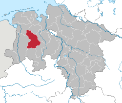
Cloppenburg (district)
| Cloppenburg | ||
|---|---|---|
| District | ||
| ||
 | ||
| Country |
| |
| State | Lower Saxony | |
| Capital | Cloppenburg | |
| Area | ||
| • Total | 1,418 km2 (547 sq mi) | |
| Population (31 December 2015)[1] | ||
| • Total | 164,734 | |
| • Density | 120/km2 (300/sq mi) | |
| Time zone | CET (UTC+1) | |
| • Summer (DST) | CEST (UTC+2) | |
| Vehicle registration | CLP | |
| Website | lkclp.de | |
Cloppenburg is a district in Lower Saxony, Germany. It is bounded by (from the north and clockwise) the districts of Ammerland, Oldenburg, Vechta, Osnabrück, Emsland and Leer.
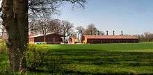
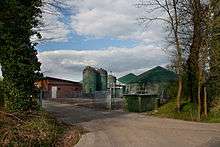
Like the neighbouring Vechta district, it is well known for factory farming, especially of turkeys and pigs. These two districts are also known as the Schweinegürtel (“pig belt”). The ground is mostly of poor quality. The mass import of animal food made factory farming possible. With the help of liquid manure, corn is grown, which is also used for a growing production of biogas.[2]
History
The region was part of the county of Tecklenburg in medieval times. It was then for a long time (1400-1803) property of the bishop of Münster. In 1803 it was annexed by Oldenburg and remained a part of Oldenburg until 1945. The district was established in 1933.
Geography
The district comprises the western portion of a historical region called Oldenburgisches Münsterland, which means "lands of Oldenburg formerly held by Münster". It is a plain countryside, which was originally swampy and full of tiny rivers and brooks.
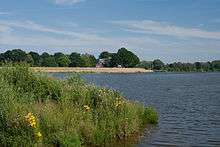
The Thülsfelde Reservoir is an artificial lake that was built between 1924 and 1927 in order to prevent floods in the area. Today it is a major tourist attraction with several camping sites and a youth hostel.
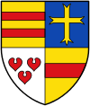
Coat of arms
The coat of arms displays:
- top left and top right: the cross as well as the red stripes are part of the arms of Oldenburg
- bottom left: three water lilly leaves made up the arms of Tecklenburg
- bottom right: red and yellow are the colours of Münster
Its blazon is: "Quarterly; I: Or, two bars Gules; II: Azure, a cross Or; III: Argent, three water lily leaves Gules; IV: Or, a fess Gules".
Towns and municipalities
| Towns | Municipalities | |
|---|---|---|
References
- ↑ Landesbetrieb für Statistik und Kommunikationstechnologie Niedersachsen, 102 Bevölkerung - Basis Zensus 2011, Stand 31. Dezember 2015 (Tabelle K1020014)
- ↑ Wilking, Johannes und Manfred Kayser: Biogaserzeugung im Oldenburger Münsterland - Entwicklungen und Perspektiven. In: Jahrbuch für das Oldenburger Münsterland 2011. Vechta 2010, S. 196-219
External links
![]() Media related to Landkreis Cloppenburg at Wikimedia Commons
Media related to Landkreis Cloppenburg at Wikimedia Commons
- Official website (German)
| Region | |
|---|---|
| Urban districts | |
| Rural districts |
|
Coordinates: 52°50′N 8°00′E / 52.83°N 8.0°E