Geography of the Dominican Republic
 | |
| Continent | Americas |
|---|---|
| Region |
Caribbean Greater Antilles |
| Coordinates | 19°00' N 70°40' W |
| Area | Ranked 132nd |
| • Total | 48,670 km2 (18,790 sq mi) |
| Coastline | 1,288 km (800 mi) |
| Borders |
Total land borders: 275 km |
| Highest point |
Pico Duarte 3,098 m |
| Lowest point |
Lake Enriquillo -46 m |
| Longest river | Yaque del Norte River |
| Largest lake | Lake Enriquillo |
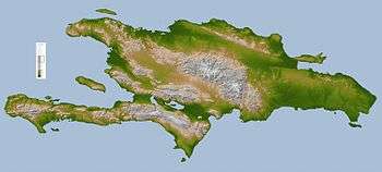
The Dominican Republic (Spanish: República Dominicana) is a country in the West Indies that occupies the eastern five-eighths of Hispaniola. It has an area of 48,670 km², including offshore islands. The land border shared with Haiti, which occupies the western three-eighths of the island, is 376 km long.[1][2] The maximum length, east to west, is 390 km from Punta de Agua to Las Lajas, on the border with Haiti. The maximum width, north to south, is 265 km from Cape Isabela to Cape Beata.[3] The capital, Santo Domingo, is located on the south coast.
The Dominican Republic's shores are washed by the Atlantic Ocean to the north and the Caribbean Sea to the south. The Mona Passage, a channel about 130 km wide, separates the country (and Hispaniola) from Puerto Rico.
Statistics
- Location
- Caribbean, it occupies five-eighths of the island of Hispaniola, between the Caribbean Sea and the North Atlantic Ocean, east of Haiti
- Geographic coordinates
- 19°00′N 70°40′W / 19.000°N 70.667°W
- Map references
- Central America and the Caribbean
- Area
-
- Total: 48,670 km²
- Land: 48,320 km²
- Water: 350 km²
- Area - comparative
- Approximately the size of Vermont and New Hampshire combined
- Land boundaries
- Coastline
- 1,288 km
- Maritime claims
-
- Territorial sea: 6 nmi (11.1 km; 6.9 mi)
- Contiguous zone: 24 nmi (44.4 km; 27.6 mi)
- Exclusive economic zone: 200 nmi (370.4 km; 230.2 mi)
- Continental shelf: 200 nmi (370.4 km; 230.2 mi) or to the edge of the continental margin
- Climate
- Tropical maritime; little seasonal temperature variation; seasonal variation in rainfall
- Rivers
- Significant rivers include the Jimani River, Río Yaque del Norte, Río Jamao del Norte, Río Isabela and the Ozama River
- Terrain
- Rugged highlands and mountains with fertile valleys interspersed
- Elevation extremes
-
- Lowest point: Lago Enriquillo -46 m
- Highest point: Pico Duarte 3,098 m
- Natural resources
- Nickel, bauxite, gold, silver
- Land use
-
- Arable land: 16.56%
- Permanent crops: 10.35%
- Other: 73.10% (2012 est.)
- Irrigated land
- 3,065 km² (2009)
- Total renewable water resources
- 21 km3 (2011)
- Freshwater withdrawal (domestic/industrial/agricultural)
-
- total: 5.47 km3/yr (26%/1%/72%)
- per capita: 574.2 m3/yr (2005)
- Natural hazards
- Lies in the middle of the hurricane belt and subject to severe storms from June to October; occasional flooding; periodic droughts
- Environment - current issues
- Water shortages; soil eroding into the sea damages coral reefs; deforestation; damage caused by Hurricane Georges
- Environment - international agreements
-
- Party to: Biodiversity, Climate Change, Desertification, Endangered Species, Marine Dumping, Marine Life Conservation, Nuclear Test Ban, Ozone Layer Protection, Ship Pollution, Wetlands
- Signed, but not ratified: Law of the Sea
- Geography - note
- Shares island of Hispaniola with Haiti (eastern five-eighths is the Dominican Republic, western three-eighths is Haiti)[1][2]
Climate
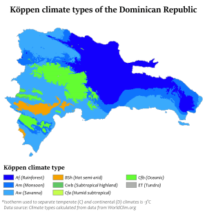
The country is a tropical, maritime nation. Conditions are ameliorated in many areas by elevation and by the northeast trade winds, which blow steadily from the Atlantic all year long. The annual mean temperature is 25 °C (77 °F); regional mean temperatures range from 18 °C (64.4 °F) in the heart of the Cordillera Central (Constanza) to as high as 27 °C (80.6 °F) in arid regions. Temperatures rarely rise above 32 °C (89.6 °F), and freezing temperatures only occur in winter in the highest mountains. The average temperature in Santo Domingo in January is 24 °C (75.2 °F), and 27 °C (80.6 °F) in July.
The rain season for the northern coast is from November to January. For the rest of the country, the rain season is from May to November. The average annual rainfall is 1,346 mm (53.0 in), with extremes of 2,500 mm (98.4 in) or more in the mountainous northeast (the windward side of the island) and 500 mm (19.7 in) in the southwestern valleys. The western valleys, along the Haitian border, remain relatively dry, with less than 760 mm (29.9 in) of annual precipitation, due to the rain shadow effect caused by the central and northern mountain ranges. The northwestern and southeastern extremes of the country are also arid.
The Dominican Republic is occasionally damaged by tropical storms and hurricanes, which originate in the mid-Atlantic and southeastern Caribbean from June until November (mainly from August to October) each year.
Islands
There are several smaller islands and cays that are part of the Dominican territory. The largest islands are:
- Saona, close to the southeastern coast of the Hispaniola, in the Caribbean Sea. It has an area of 117 km².[3] Its Taíno name was Iai [4] or Adamanay. Columbus named this island as Savona after the Italian city of the same name but the use during years has eliminated the letter v.
- Beata, in the southern coast of the Hispaniola, in the Caribbean Sea. It has an area of 27 km².[3] Its Taíno name is unknown. Columbus named this island as Madama Beata.
- Catalina, very close to the southeastern coast of the Hispaniola, in the Caribbean Sea. It has an area of 9.6 km².[3] Its Taíno name was Iabanea[4] but some writers, including poets, say that it was called Toeya or Toella. It was discovered by Columbus who named it Santa Catalina.
Relief

The Dominican Republic is a country with many mountains, and the highest peaks of the West Indies are found here. The chains of mountains show a direction northwest-southeast, except in the Southern peninsula (in Haiti) where they have a direction west-east. The mountains are separated by valleys with the same general direction.
From north to south, the mountain ranges and valleys are:[5]
- Cordillera Septentrional (in English, "Northern Range"). It runs parallel to the north coast, with extensions to the northwest, the Tortuga Island, and to the southeast, the Samaná Peninsula (with its Sierra de Samaná). Its highest mountain is Diego de Ocampo, close to Santiago, with 1,249 m. There are several small plains between this range and the Atlantic Ocean. Rivers are short and most of them flow to the north.
- The Cibao Valley (Dominican Republic) is the largest and the most important valley of the country. This long valley stretches from North Haiti, where is called Plaine du Nord, to Samaná Bay. It can be divided in two sections: the northwestern part is the Yaque del Norte Valley (or Línea Noroeste) and the eastern Yuna Valley (or Vega Real, English: Royal Valley). The Vega Real is the most fertile area in the country, with a high population density.
- The Cordillera Central (also called Sierra del Cibao) is the island's most rugged and imposing feature and is known in Haiti as the Massif du Nord ("Northern Massif"). The highest mountains of the West Indies are in this range: Pico Duarte, 3,098 m, and others above 3,000 m. Near the center of the island, this range turns southward and is called Sierra de Ocoa, finishing near the city of Azua de Compostela, on the Caribbean coast. Another branch, Cordillera Oriental or Sierra del Seibo, is separated from the main chain by a karstic region (Los Haitises) and with a west-east direction; it is located south of Samaná Bay.
- The San Juan Valley and Plain of Azua are big valleys south of the Cordillera Central with altitude from 0 to 600 m.
- The Sierra de Neiba, with Mount Neiba the highest mountain with 2,279 m. An extension to the southeast of Sierra de Neiba is the Sierra Martín García (Loma Busú, 1,350 m).
- The Hoya de Enriquillo or Neiba Valley is a remarkable valley, with a west-east direction, of low altitude (on average 50 m with some points below sea level) and with a great salt lake: the Enriquillo Lake.
- The Sierra de Bahoruco, called Massif de la Selle in Haiti. This southern group of mountains have a geology very different from the rest of the island.
- Llano Costero del Caribe (in English, "Caribbean Coastal Plain") is in the southeast of the island (and of the Dominican Republic). It is a large prairie east of Santo Domingo.

Rivers and lakes
The 8 longest rivers of the Dominican Republic are:[6]
- Yaque del Norte. With 296 km, it is the longest river of the Dominican Republic. Its sources are in the Cordillera Central and flows to the Atlantic Ocean. Its watershed has an area of 7,044 km².
- Yuna. It is 209 km long. Its sources are in the Cordillera Central and flows to the east into Samaná Bay. Its watershed has an area of 5,498 km².
- Yaque del Sur. It is 183 km long and its sources are in the Cordillera Central. It flows to the south into the Caribbean Sea. Its watershed has an area of 4,972 km².
- Ozama. It is 148 km long. Its sources are in Sierra de Yamasá (a branch of the Cordillera Central). It flows into the Caribbean Sea. Its watershed has an area of 2,685 km².
- Camú. It is 137 km long. Its sources are in the Cordillera Central and flows into the Yuna River. Its watershed has 2,655 km².
- Nizao. It is 133 km long. Its sources are in the Cordillera Central and flows to the south into the Caribbean Sea. Its watershed has an area of 974 km².
- San Juan. It is 121 km long. Its sources are in the Cordillera Central and flows to the south into the Yaque del Sur River. Its watershed has an area of 2,005 km².
- Mao. It is 105 km long. Its sources are in the Cordillera Central and flows to the north into the Yaque del Norte River. Its watershed has an area of 864 km².
The Artibonite River is the longest river of the island but only 68 km are in the Dominican Republic.
The largest lake of the Hispaniola, and of the West Indies, is the Lake Enriquillo. It is located in the Hoya de Enriquillo with an area of 265 km². There are three small islands within the lake. It is around 40 meters below sea level and is a saline lake with a higher concentration of salt than the sea water.
Others lakes are Rincón (fresh water, area of 28.2 km²), Oviedo (brackish water, area of 28 km²), Redonda, Limón.
References
- 1 2 "Hispaniola Article". Britannica.com. Retrieved 4 January 2014.
- 1 2 "Dominican Republic 2014". Retrieved 24 April 2014.
- 1 2 3 4 De la Fuente, Santiago (1976). Geografía Dominicana. Santo Domingo, Dominican Republic: Editora Colegial Quisqueyana. pp. 90–92.
- 1 2 As shown in a map made by Andrés Morales in 1508 and published in 1516. In Vega, Bernardo (1989). Los Cacicazgos de la Hispaniola. Santo Domingo, Dominican Republic: Museo del Hombre Dominicano. p. 88.
- ↑ Butterlin, Jacques (1977). Géologie Structural de la Région des Caraïbes (in French). Paris: Masson. pp. 110–111. ISBN 2-225-44979-1.
- ↑ De la Fuente, Santiago (1976). Geografía Dominicana. Santo Domingo, Dominican Republic: Editora Colegial Quisqueyana. pp. 110–114.
Geography of North America | ||
|---|---|---|
| Sovereign states |  | |
Dependencies and other territories | ||