Climate of Svalbard
The climate of Svalbard is principally a result of its latitude, which is between 74° and 81° north. Average July temperatures range from 3 and 7 °C (37.4 and 44.6 °F) , and in January temperatures are normally between −13 and −20 °C (8.6 and −4.0 °F).[1] The North Atlantic Current moderates Svalbard's temperatures, particularly during winter, giving it up to 20 °C (68 °F) higher winter temperature than similar latitudes in continental Russia and Canada. This keeps the surrounding waters open and navigable most of the year. The interior fjord areas and valleys, sheltered by the mountains, have less temperature differences than the coast, giving about 2 °C lower summer temperatures and 3 °C higher winter temperatures. On the south of Spitsbergen, the temperature is slightly higher than further north and west. During winter, the temperature difference between south and north is typically 5 °C, while only about 3 °C in summer. Bear Island has average temperatures even higher than the rest of the archipelago.[2]
The archipelago is the meeting place for cold polar air from the north and mild, wet sea air from the south, creating low pressure and changing weather and fast winds, particularly in winter; in January, a strong breeze is registered 17% of the time at Isfjord Radio, but only 1% of the time in July. In summer, particularly away from land, fog is common, with visibility under 1 kilometre (0.62 mi) registered 20% of the time in July and 1% of the time in January, at Hopen and Bear Island.[3] Precipitation is frequent, but falls in small quantities, typically less than 400 millimetres (15.7 in) in Western Spitsbergen. More rain falls in the uninhabited east side, where there can be more than 1,000 millimetres (39.4 in).[3]
The warmest temperature ever recorded was 21.3 °C (70.3 °F) in July 1979 and the coldest was −46.3 °C (−51.3 °F) in March 1986.
| Climate data for Longyearbyen | |||||||||||||
|---|---|---|---|---|---|---|---|---|---|---|---|---|---|
| Month | Jan | Feb | Mar | Apr | May | Jun | Jul | Aug | Sep | Oct | Nov | Dec | Year |
| Record high °C (°F) | 7.7 (45.9) |
6 (43) |
6.3 (43.3) |
7.5 (45.5) |
10.6 (51.1) |
15.7 (60.3) |
21.3 (70.3) |
18.1 (64.6) |
15.2 (59.4) |
8.9 (48) |
7.5 (45.5) |
7.2 (45) |
21.3 (70.3) |
| Average high °C (°F) | −13.0 (8.6) |
−13.0 (8.6) |
−13.0 (8.6) |
−9.0 (15.8) |
−3.0 (26.6) |
3.0 (37.4) |
7.0 (44.6) |
6.0 (42.8) |
1.0 (33.8) |
−4.0 (24.8) |
−8.0 (17.6) |
−11.0 (12.2) |
−4.7 (23.45) |
| Daily mean °C (°F) | −16.5 (2.3) |
−17 (1) |
−16.5 (2.3) |
−12.5 (9.5) |
−5 (23) |
1 (34) |
5 (41) |
4 (39) |
−1 (30) |
−6.5 (20.3) |
−11 (12) |
−14.5 (5.9) |
−7.54 (18.36) |
| Average low °C (°F) | −20.0 (−4) |
−21.0 (−5.8) |
−20.0 (−4) |
−16.0 (3.2) |
−7.0 (19.4) |
−1.0 (30.2) |
3.0 (37.4) |
2.0 (35.6) |
−3.0 (26.6) |
−9.0 (15.8) |
−14.0 (6.8) |
−18.0 (−0.4) |
−10.3 (13.4) |
| Record low °C (°F) | −38.8 (−37.8) |
−43.7 (−46.7) |
−46.3 (−51.3) |
−39.1 (−38.4) |
−21.7 (−7.1) |
−8.4 (16.9) |
0.2 (32.4) |
−3.9 (25) |
−12.6 (9.3) |
−20.8 (−5.4) |
−33.2 (−27.8) |
−35.6 (−32.1) |
−46.3 (−51.3) |
| Average precipitation mm (inches) | 22.0 (0.866) |
28.0 (1.102) |
29.0 (1.142) |
16.0 (0.63) |
13.0 (0.512) |
18.0 (0.709) |
24.0 (0.945) |
30.0 (1.181) |
25.0 (0.984) |
19.0 (0.748) |
22.0 (0.866) |
25.0 (0.984) |
271 (10.669) |
| Average rainy days (≥ 1 mm) | 2 | 2 | 2 | 3 | 4 | 13 | 17 | 18 | 14 | 5 | 3 | 3 | 86 |
| Average snowy days (≥ 1 cm) | 21 | 17 | 19 | 17 | 16 | 7 | 1 | 2 | 11 | 21 | 22 | 22 | 176 |
| Mean monthly sunshine hours | 0.0 | 0.0 | 77.5 | 228 | 254.2 | 165 | 155 | 133.3 | 75 | 12.4 | 0.0 | 0.0 | 1,102 |
| Percent possible sunshine | 0 | 0 | n/a | n/a | 34.2 | 22.9 | 20.8 | n/a | n/a | n/a | 0 | 0 | 25.1 |
| Source: Climate and daylight in Svalbard (Longyearbyen)[4] | |||||||||||||
Historical data
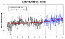
Because of its history of human occupation, Svalbard has one of the longest high-latitude meteorological records on earth. Computer models of global climate have long predicted enhanced greenhouse warming at such latitudes, so the Svalbard record is of particular interest.[5] It shows approximately 6 °C (10.8 °F) increase in 100 years; with 4 °C (7.2 °F) increase in the last 30 years.
Meteorology
Traditionally weather had been forecast for Spitsbergen, which because of the needs of expeditions and the governor's activities gave the most extreme weather on the archipelago. This included forecasts for weather-exposed locations such as Hinlopen, Sørkapp and Danes Island. As most people live in the sheltered area of Nordenskiöld Land, the forecast was often regarded as irrelevant. The Norwegian Meteorological Institute started from 14 October 2011 issuing two forecasts, one which is publicly broadcast and covers the main settlements of Longyearbyen, Barentsburg and Svea ("Nordenskiöld Land"), and one that covers the entire archipelago ("Spitsbergen").[6]
References
- ↑ "Temperaturnormaler for Spitsbergen i perioden 1961 - 1990" (in Norwegian). Norwegian Meteorological Institute. Archived from the original on 4 March 2012. Retrieved 24 March 2010.
- ↑ Torkilsen (1984): 98–99
- 1 2 Torkilsen (1984): 101
- ↑ "Climate and daylight in Svalbard (Longyearbyen)". NordicVisitor. Retrieved May 2011. Check date values in:
|access-date=(help) - ↑ RealClimate
- ↑ "Nordenskiöld Land". Norwegian Meteorological Institute. 14 October 2011. Archived from the original on 15 March 2012. Retrieved 15 March 2012.
Bibliography
- Torkildsen, Torbjørn; et al. (1984). Svalbard: vårt nordligste Norge (in Norwegian). Oslo: Forlaget Det Beste. ISBN 82-7010-167-2.