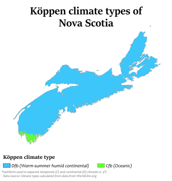
Climate of Nova Scotia
Nova Scotia lies in the mid-temperate zone and, although the province is almost surrounded by water, the climate is closer to continental rather than maritime. The temperature extremes of the continental climate are moderated by the ocean.
Nova Scotia has frequent coastal fog and marked changeability of weather from day to day. The main factors influencing Nova Scotia's climate are:
- The effects of the westerly winds
- The interaction between three main air masses which converge on the east coast
- Nova Scotia's location on the routes of the major eastward-moving storms
- The modifying influence of the sea.
Described on the provincial vehicle-licence plate as Canada's Ocean Playground, the sea is a major influence on Nova Scotia's climate. Nova Scotia's cold winters and warm summers are modified and generally moderated by ocean influences. The province is surrounded by four major bodies of water, the Gulf of Saint Lawrence to the north, the Bay of Fundy to the west, the Gulf of Maine to the southwest, and Atlantic Ocean to the southeast.
Temperature and precipitation
Temperature varies marginally from one end of the province to the other, and more notably in terms of precipitation, as illustrated by the following graphs. They show Yarmouth, Halifax and Sydney representing the southwestern, central and northeastern extremes, respectively. Temperatures at the southern end of the province are moderated by oceanic (Gulf Stream) currents, whereas the northern end is influenced by the colder waters of the Gulf of St. Lawrence. Though milder, and with less winter precipitation, the southeastern end has more fog.
| Yarmouth | ||||||||||||||||||||||||||||||||||||||||||||||||||||||||||||
|---|---|---|---|---|---|---|---|---|---|---|---|---|---|---|---|---|---|---|---|---|---|---|---|---|---|---|---|---|---|---|---|---|---|---|---|---|---|---|---|---|---|---|---|---|---|---|---|---|---|---|---|---|---|---|---|---|---|---|---|---|
| Climate chart (explanation) | ||||||||||||||||||||||||||||||||||||||||||||||||||||||||||||
| ||||||||||||||||||||||||||||||||||||||||||||||||||||||||||||
| ||||||||||||||||||||||||||||||||||||||||||||||||||||||||||||
| Halifax (Citadel) | ||||||||||||||||||||||||||||||||||||||||||||||||||||||||||||
|---|---|---|---|---|---|---|---|---|---|---|---|---|---|---|---|---|---|---|---|---|---|---|---|---|---|---|---|---|---|---|---|---|---|---|---|---|---|---|---|---|---|---|---|---|---|---|---|---|---|---|---|---|---|---|---|---|---|---|---|---|
| Climate chart (explanation) | ||||||||||||||||||||||||||||||||||||||||||||||||||||||||||||
| ||||||||||||||||||||||||||||||||||||||||||||||||||||||||||||
| ||||||||||||||||||||||||||||||||||||||||||||||||||||||||||||
| Sydney | ||||||||||||||||||||||||||||||||||||||||||||||||||||||||||||
|---|---|---|---|---|---|---|---|---|---|---|---|---|---|---|---|---|---|---|---|---|---|---|---|---|---|---|---|---|---|---|---|---|---|---|---|---|---|---|---|---|---|---|---|---|---|---|---|---|---|---|---|---|---|---|---|---|---|---|---|---|
| Climate chart (explanation) | ||||||||||||||||||||||||||||||||||||||||||||||||||||||||||||
| ||||||||||||||||||||||||||||||||||||||||||||||||||||||||||||
| ||||||||||||||||||||||||||||||||||||||||||||||||||||||||||||
Temperature
In 1990, While the constant temperature of the Atlantic Ocean moderates the climate of the south and east coasts of Nova Scotia, heavy ice build-up in the Gulf of Saint Lawrence makes winters colder in northern Nova Scotia; the shallowness of the Gulf's waters mean that they warm up more than the Atlantic Ocean in the summer, warming the summers in northern Nova Scotia. Summer unofficially lasts from the first Sunday in April to the Saturday before the last Sunday in October. Although Nova Scotia has a somewhat moderated climate, there have been some very intense heatwaves and cold snaps recorded over the past 160 years. The highest temperature ever recorded in the province was 38.3 °C (101 °F) on August 19, 1935, at Collegeville,[4] which is located about 15 km southwest of Antigonish. The coldest temperature ever recorded was −41.1 °C (−42 °F) on January 31, 1920, at Upper Stewiacke.[5]
The highest temperature ever recorded in Halifax was 37.2 °C (99 °F) on July 10, 1912,[6] and the lowest was −29.4 °C (−21 °F) on Feb 18, 1922.[7] For Sydney, the highest temperature ever recorded was 36.7 °C (98 °F) on August 18, 1935,[8] and the lowest was −31.7 °C (−25 °F) on January 31, 1873,[9] and January 29, 1877.[10]
The annual temperatures are:
- Spring from 1 °C (34 °F) to 17 °C (63 °F)
- Summer from 14 °C (57 °F) to 28 °C (82 °F)[11]
- Autumn about 5 °C (41 °F) to 20 °C (68 °F)
- Winter about −9 °C (16 °F) to 0 °C (32 °F)
Due to the ocean's moderating effect, Nova Scotia, on average, is the warmest of the provinces in Canada, owing primarily to the milder winter temperatures experienced in Nova Scotia compared to the rest of Canada.[12]
Rainfall

All of Nova Scotia has precipitation well distributed around the year, with a slight summer maximum in some northern/interior areas, but a slight fall to early winter (October to January) maximum in southern and coastal areas, where July or August is the driest month on average. Fall and winter storms, arriving in or near Nova Scotia from the U.S. Northeastern and New England states (called "nor'easters" in the US), often attain tremendous intensity across coastal areas, resulting in high winds, heavy rain, ice or snow and sometimes all of the above in a single storm. Average annual precipitation changes from 140 centimetres (55 in) in the south with its intense cold-season storm activity, to 100 centimetres (40 in) elsewhere. In the northeast, Sydney is an especially wet area, with an average annual precipitation of nearly 60 inches, with a noticeable fall to early winter (October to January) concentration, and December the wettest month on average. Nova Scotia is also very foggy in places, with Halifax averaging 196 foggy days per year[13] and Yarmouth 191.[14]
Storms
Because Nova Scotia juts out into the Atlantic, it is prone to intense cold-season storms ("nor'easters" - primarily November to March) arriving from the Northeastern United States, and occasional tropical storms and hurricanes in late summer and autumn. However due to the relatively cooler waters off the coast of Nova Scotia, tropical storms are usually weak by the time they reach Nova Scotia. Even where a storm retains much of its strength, as with Hurricane Arthur, it is most often extratropical by the time it makes landfall on Nova Scotia.
Altogether there have been 33 such storms, including 12 hurricanes, since records were kept in 1871 – about once every four years. In addition, at least two of these hurricanes (Juan and Ginny) made landfall at Category 2 intensity (there are no recorded Category 3 landfalls). The last hurricane was category-one Hurricane Earl in September 2010, and the last tropical storm was Tropical Storm Noel in 2007 (downgraded from Hurricane Noel by the time the storm reached Nova Scotia). The most destructive hurricane was Hurricane Juan in 2003.
Very high winds are frequently experienced in Grand Étang in northern Nova Scotia, which result from the effect of low mountains on southwesterly winds. They are known as Suetes.
References
- ↑ "Yarmouth A". Canadian Climate Normals 1981–2010 (in English and French). Environment Canada. Retrieved 28 September 2015.
- ↑ "Halifax Citadel". Canadian Climate Normals 1981–2010 (in English and French). Environment Canada. Retrieved 28 September 2015.
- ↑ "Sydney NS". Canadian Climate Normals 1981–2010 (in English and French). Environment Canada. Retrieved 28 September 2015.
- ↑ "Environment Canada". Climate.weatheroffice.gc.ca. August 18, 2010. Retrieved October 6, 2010.
- ↑ "Environment Canada". Climate.weatheroffice.gc.ca. August 18, 2010. Retrieved October 6, 2010.
- ↑ "Environment Canada". Climate.weatheroffice.gc.ca. August 18, 2010. Retrieved October 6, 2010.
- ↑ "Environment Canada". Climate.weatheroffice.gc.ca. August 18, 2010. Retrieved October 6, 2010.
- ↑ "Environment Canada". Climate.weatheroffice.gc.ca. August 18, 2010. Retrieved October 6, 2010.
- ↑ "Environment Canada". Climate.weatheroffice.gc.ca. August 18, 2010. Retrieved October 6, 2010.
- ↑ "Environment Canada". Climate.weatheroffice.gc.ca. August 18, 2010. Retrieved October 6, 2010.
- ↑ Environment Canada—Atlantic Climate Centre—The Climate of Nova Scotia Archived April 19, 2010, at the Wayback Machine.
- ↑ "Province Data | Canada's National Climate Archive". Climate.weatheroffice.gc.ca. 2012-05-29. Retrieved 2012-07-06.
- ↑ "Historical Weather for Halifax, Nova Scotia, Canada". Weatherbase. Retrieved October 6, 2010.
- ↑ "Historical Weather for Yarmouth, Nova Scotia, Canada". Weatherbase. Retrieved October 6, 2010.