Geography of Japan
 | |
| Continent | Asia Oceania |
|---|---|
| Region | East Asia Micronesia |
| Coordinates | 35.0000° N 136.0000° E |
| Area | Ranked 61st |
| • Total | 377,915 km2 (145,914 sq mi) |
| • Land | 87.930% |
| • Water | 12.07% |
| Coastline | 29,751 km (18,486 mi) |
| Borders | None |
| Highest point | Mount Fuji |
| Lowest point | Hachirōgata |
| Longest river | Shinano River |
| Largest lake | Lake Biwa |
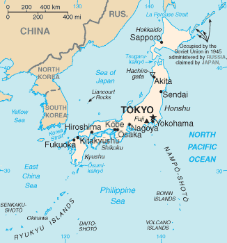
Japan is an island nation in East Asia comprising a stratovolcanic archipelago extending along the continent's Pacific coast. It lies between 24° to 46° north latitude and from 123° to 146° east longitude. Japan is southeast of the Russian Far East, separated by the Sea of Okhotsk; slightly east of Korea, separated by the Sea of Japan; and east-northeast of China and Taiwan, separated by the East China Sea. The closest neighboring country to Japan is the Russian Federation.[1]
The major islands, sometimes called the "Home Islands", are (from north to south) Hokkaidō, Honshū (the "mainland"), Shikoku and Kyūshū. There are 6,852 islands in total,[2] including the Nansei Islands, the Nanpo Islands and islets, with 430 islands being inhabited and others uninhabited. In total, as of 2006, Japan's territory is 377,923.1 km2 (145,916.9 sq mi), of which 374,834 km2 (144,724 sq mi) is land and 3,091 km2 (1,193 sq mi) water.
Location: Eastern Asia, island chain between the North Pacific Ocean and the Sea of Japan, east of the Korean Peninsula.
Area:
- total: 377,915 km²
- land: 364,485 km²
- water: 13,430 km²
- notes: Includes the Bonin Islands, Daitō Islands, Minami-Tori-shima, Okinotorishima, the Ryukyu Islands, and the Volcano Islands. Ownership of the Senkaku Islands and Liancourt Rocks (Japanese:Takeshima, Korean:Dokdo) is in dispute.
Land boundaries: none
Coastline: 29,751 km (18,486 mi)
Maritime claims:
- territorial sea: 12 nmi (22.2 km; 13.8 mi); between 3 and 12 nmi (5.6 and 22.2 km; 3.5 and 13.8 mi) in the international straits—La Pérouse (or Sōya Strait), Tsugaru Strait, Osumi, and Eastern and Western Channels of the Korea or Tsushima Strait.
- exclusive economic zone: 200 nmi (370.4 km; 230.2 mi)
- contiguous zone: 24 nmi (44.4 km; 27.6 mi)
Climate: varies from tropical in south to cool temperate in north
Terrain: mostly rugged and mountainous, can easily be compared to Norway, both having about 70% of their land in the mountains.
Natural resources: small deposits of coal, oil, iron, and minerals. Major fishing industry.
Land use:
- arable land: 11.65%
- permanent crops: 0.83%
- other: 87.52% (2012)
Irrigated land: 25,000 km² (2010)
Total renewable water resources: 430 km3 (2011)
Freshwater withdrawal (domestic/industrial/agricultural):
- total: 90.04 km3/yr (20%/18%/62%)
- per capita: 714.3 m3/yr (2007)
Composition and topography

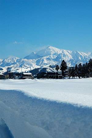
About 72% of Japan is mountainous, with a mountain range running through each of the main islands. Japan's highest mountain is Mount Fuji, with an elevation of 3,776 m (12,388 ft). Japan's forest cover rate is 68.55% since the mountains are heavily forested. The only other developed nations with such a high forest cover percentage are Finland and Sweden.[3]
Since there is little level ground, many hills and mountainsides at lower elevations around towns and cities are often cultivated. As Japan is situated in a volcanic zone along the Pacific deeps, frequent low-intensity earth tremors and occasional volcanic activity are felt throughout the islands. Destructive earthquakes occur several times a century. Hot springs are numerous and have been exploited as an economic capital by the leisure industry.
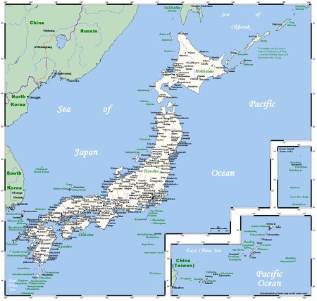
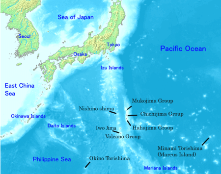
The mountainous islands of the Japanese archipelago form a crescent off the eastern coast of Asia. They are separated from the mainland by the Sea of Japan, which historically served as a protective barrier. The country consists of four major islands: Hokkaidō, Honshū, Shikoku, and Kyūshū; with more than 6,500 adjacent smaller islands and islets ("island" defined as land more than 100 m in circumference),[4] including the Izu Islands and Ogasawara Islands in the Nanpō Islands, and the Satsunan Islands, Okinawa Islands, and Sakishima Islands of the Ryukyu Islands.
The national territory also includes the Volcano Islands (Kazan Retto) such as Iwo Jima, located some 1,200 kilometers south of mainland Tokyo. A territorial dispute with Russia, dating from the end of World War II, over the two southernmost of the Kuril Islands, Etorofu and Kunashiri, and the smaller Shikotan Island and Habomai Islands northeast of Hokkaidō remains a sensitive spot in Japanese–Russian relations (as of 2005). Excluding disputed territory, the archipelago covers about 377,000 square kilometers. No point in Japan is more than 150 kilometers from the sea.
The four major islands are separated by narrow straits and form a natural entity. The Ryukyu Islands curve 970 kilometers southward from Kyūshū.
The distance between Japan and the Korean Peninsula, the nearest point on the Asian continent, is about 200 kilometers at the Korea Strait. Japan has always been linked with the continent through trade routes, stretching in the north toward Siberia, in the west through the Tsushima Islands to the Korean Peninsula, and in the south to the ports on the south China coast.
The Japanese islands are the summits of mountain ridges uplifted near the outer edge of the continental shelf. About 73 percent of Japan's area is mountainous, and scattered plains and intermontane basins (in which the population is concentrated) cover only about 27 percent. A long chain of mountains runs down the middle of the archipelago, dividing it into two halves, the "face", fronting on the Pacific Ocean, and the "back", toward the Sea of Japan. On the Pacific side are steep mountains 1,500 to 3,000 meters high, with deep valleys and gorges.
Central Japan is marked by the convergence of the three mountain chains—the Hida, Kiso, and Akaishi mountains—that form the Japanese Alps (Nihon Arupusu), several of whose peaks are higher than 3,000 meters. The highest point in the Japanese Alps is Mount Kita at 3,193 meters. The highest point in the country is Mount Fuji (Fujisan, also erroneously called Fujiyama), a volcano dormant since 1707 that rises to 3,776 meters above sea level in Shizuoka Prefecture. On the Sea of Japan side are plateaus and low mountain districts, with altitudes of 500 to 1,500 meters.
None of the populated plains or mountain basins are extensive in area. The largest, the Kantō Plain, where Tokyo is situated, covers only 13,000 square kilometers. Other important plains are the Nōbi Plain surrounding Nagoya, the Kinai Plain in the Osaka–Kyoto area, the Sendai Plain around the city of Sendai in northeastern Honshū, and the Ishikari Plain on Hokkaidō. Many of these plains are along the coast, and their areas have been increased by reclamation throughout recorded history.
The small amount of habitable land has prompted significant human modification of the terrain over many centuries. Land was reclaimed from the sea and from river deltas by building dikes and drainage, and rice paddies were built on terraces carved into mountainsides. The process continued in the modern period with extension of shorelines and building of artificial islands for industrial and port development, such as Port Island in Kobe and the new Kansai International Airport in Osaka Bay. Hills and even mountains have been razed to provide flat areas for housing.
Rivers are generally steep and swift, and few are suitable for navigation except in their lower reaches. Most rivers are less than 300 kilometers in length, but their rapid flow from the mountains provides a valuable, renewable resource: hydroelectric power generation. Japan's hydroelectric power potential has been exploited almost to capacity. Seasonal variations in flow have led to extensive development of flood control measures. Most of the rivers are very short. The longest, the Shinano River, which winds through Nagano Prefecture to Niigata Prefecture and flows into the Sea of Japan, is only 367 kilometers long. The largest freshwater lake is Lake Biwa, northeast of Kyoto.
Extensive coastal shipping, especially around the Seto Inland Sea (Seto Naikai), compensates for the lack of navigable rivers. The Pacific coastline south of Tokyo is characterized by long, narrow, gradually shallowing inlets produced by sedimentation, which has created many natural harbors. The Pacific coastline north of Tokyo, the coast of Hokkaidō, and the Sea of Japan coast are generally unindented, with few natural harbors.
In November 2008, Japan filed a request to expand its claimed continental shelf.[5] In April 2012, the U.N. Commission on the Limits of the Continental Shelf recognized around 310,000 square kilometres (120,000 sq mi) of seabed around Okinotorishima, giving Japan priority over access to seabed resources in nearby areas. According to U.N. Commission on the Limits of the Continental Shelf, the approved expansion is equal to about 82% of Japan's total land area.[5] The People's Republic of China and South Korea have opposed Japan's claim because they view Okinotorishima not as an island, but a group of rocks.
Climate


Most regions of Japan, such as much of Honshu, Shikoku and Kyushu, belong to the temperate zone with humid subtropical climate (Köppen climate classification Cfa) characterized by four distinct seasons. However, its climate varies from cool humid continental climate (Köppen climate classification Dfb) in the north such as northern Hokkaido, to warm tropical rainforest climate (Köppen climate classification Af) in the south such as Ishigaki in the Yaeyama Islands.
The two primary factors influences in Japan's climate are a location near the Asian continent and the existence of major oceanic currents. Two major ocean currents affect Japan: the warm Kuroshio Current (Black Current; also known as the Japan Current); and the cold Oyashio Current (Parent Current; also known as the Okhotsk Current). The Kuroshio Current flows northward on the Pacific side of Japan and warms areas as north as the South Kantō region; a small branch, the Tsushima Current, flows up the Sea of Japan side. The Oyashio Current, which abounds in plankton beneficial to coldwater fish, flows southward along the northern Pacific, cooling adjacent coastal areas. The intersection of these currents at 36 north latitude is a bountiful fishing ground.
Its varied geographical features divide Japan into six principal climatic zones.
- Hokkaidō (北海道 Hokkaidō): Belonging to the humid continental climate, Hokkaidō has long, cold winters and cool summers. Precipitation is not great.
- Sea of Japan (日本海 Nihonkai): The northwest seasonal wind in winter gives heavy snowfall, which south of Tohoku mostly melts before the beginning of spring. In summer it is a little less rainy than the Pacific area but sometimes experiences extreme high temperatures due to the foehn wind phenomenon.
- Central Highland (中央高地 Chūō-kōchi): A typical inland climate gives large temperature variations between summers and winters and between days and nights. Precipitation is lower than on the coast due to rain shadow effects.
- Seto Inland Sea (瀬戸内海 Setonaikai): The mountains in the Chūgoku and Shikoku regions block the seasonal winds and bring mild climate and many fine days throughout the year.
- Pacific Ocean (太平洋 Taiheiyō): The climate varies greatly between the north and the south but generally winters are significantly milder and sunnier than those of the side that faces the Sea of Japan. Summers are hot and humid due to the southeast seasonal wind. Precipitation is very heavy in the south, and heavy in the summer in the north. The climate of the Ogasawara Island chain in the Pacific Ocean ranges from a humid subtropical climate (Köppen climate classification Cfa) to tropical savanna climate (Köppen climate classification Aw) with temperatures being warm to hot all year round.
- Ryukyu Islands (南西諸島 Nansei-shotō): The climate of these islands ranges from humid subtropical climate (Köppen climate classification Cfa) in the north to tropical rainforest climate (Köppen climate classification Af) in the south with warm winters and hot summers. Precipitation is very high, and is especially affected by the rainy season and typhoons.
Japan is generally a rainy country with high humidity. Because of its wide range of latitude, seasonal winds and different types of ocean currents, Japan has a variety of climates, with a latitude range of the inhabited islands from 24° to 46° north, which is comparable to the range between Nova Scotia and The Bahamas in the east coast of North America. Tokyo is at about 35 degrees north latitude, comparable to that of Tehran, Athens, or Las Vegas.
Regional climatic variations range from humid continental in the northern island of Hokkaido extending down through northern Japan to the Central Highland, then blending with and eventually changing to a humid subtropical climate on the Pacific Coast and ultimately reaching tropical rainforest climate on the Yaeyama Islands of the Ryukyu Islands. Climate also varies dramatically with altitude and with location on the Pacific Ocean or on the Sea of Japan.
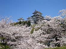
Northern Japan has warm summers but long, cold winters with heavy snow. Central Japan in its elevated position, has hot, humid summers and moderate to short winters with some areas having very heavy snow, and southwestern Japan has long, hot, humid summers and mild winters. The generally humid, temperate climate exhibits marked seasonal variation such as the blooming of the spring cherry blossoms, the calls of the summer cicada and fall foliage colors that are celebrated in art and literature.
The climate from June to September is marked by hot, wet weather brought by tropical airflows from the Pacific Ocean and Southeast Asia. These airflows are full of moisture and deposit substantial amounts of rain when they reach land. There is a marked rainy season, beginning in early June and continuing for about a month. It is followed by hot, sticky weather. Five or six typhoons pass over or near Japan every year from early August to early October, sometimes resulting in significant damage. Annual precipitation averages between 1,000 and 2,500 mm (40 and 100 in) except for the areas such as Kii Peninsula and Yakushima Island which is Japan's wettest place[6] with the annual precipitation being one of the world's highest at 4,000 to 10,000 mm.[7]
Maximum precipitation, like the rest of East Asia, occurs in the summer months except on the Sea of Japan coast where strong northerly winds produce a maximum in late autumn and early winter. Except for a few sheltered inland valleys during December and January, precipitation in Japan is above 25 millimetres (1 in) of rainfall equivalent in all months of the year, and in the wettest coastal areas it is above 100 millimetres (4 in) per month throughout the year.
In winter, the Siberian High develops over the Eurasian land mass and the Aleutian Low develops over the northern Pacific Ocean. The result is a flow of cold air southeastward across Japan that brings freezing temperatures and heavy snowfalls to the central mountain ranges facing the Sea of Japan, but clear skies to areas fronting on the Pacific.
Mid June to mid July is generally the rainy season in Honshu, Shikoku and Kyushu, excluding Hokkaidō since the seasonal rain front or baiu zensen (梅雨前線) dissipates in northern Honshu before reaching Hokkaido. In Okinawa, the rainy season starts early in May and continues until mid June. Unlike the rainy season in mainland Japan, it rains neither everyday nor all day long during the rainy season in Okinawa. Between July and October, typhoons, grown from tropical depressions generated near the equator, can attack Japan with furious rainstorms.
The warmest winter temperatures are found in the Nanpō and Bonin Islands, which enjoy a tropical climate due to the combination of latitude, distance from the Asian mainland, and warming effect of winds from the Kuroshio, as well as the Volcano Islands (at the latitude of the southernmost of the Ryukyu Islands, 24° N). The coolest summer temperatures are found on the northeastern coast of Hokkaidō in Kushiro and Nemuro Subprefectures.
Sunshine, in accordance with Japan’s uniformly heavy rainfall, is generally modest in quantity, though no part of Japan receives the consistently gloomy fogs that envelope the Sichuan Basin or Taipei. Amounts range from about six hours per day in the Inland Sea coast and sheltered parts of the Pacific Coast and Kantō Plain to four hours per day on the Sea of Japan coast of Hokkaidō. In December there is a very pronounced sunshine gradient between the Sea of Japan and Pacific coasts, as the former side can receive less than 30 hours and the Pacific side as much as 180 hours. In summer, however, sunshine hours are lowest on exposed parts of the Pacific coast where fogs from the Oyashio current create persistent cloud cover similar to that found on the Kuril Islands and Sakhalin.
As an island nation, Japan has the 6th longest coastline in the world.[8] A few prefectures are landlocked: Gunma, Tochigi, Saitama, Nagano, Yamanashi, Gifu, Shiga, and Nara. As Mt. Fuji and the coastal Japanese Alps provide a rain shadow, Nagano and Yamanashi Prefectures receive the least precipitation in Honshū, though this still exceeds 900 millimetres (35 in) annually. A similar effect is found in Hokkaidō, where Okhotsk Subprefecture receives as little as 750 millimetres (30 in) per year. All other prefectures have coasts on the Pacific Ocean, Sea of Japan, Seto Inland Sea or have a body of salt water connected to them. Two prefectures—Hokkaidō and Okinawa—are composed entirely of islands.
The hottest temperature ever measured in Japan, 41.0 °C (105.8 °F), occurred in Shimanto, Kochi on August 12, 2013.[9]
Environmental issues
Environment - current issues: In the 2006 environment annual report,[10] the Ministry of Environment reported that current major issues are: global warming and preservation of the ozone layer, conservation of the atmospheric environment, water and soil, waste management and recycling, measures for chemical substances, conservation of the natural environment and the participation in the international cooperation.
Environment - international agreements:
party to: Antarctic-Environmental Protocol, Antarctic Treaty, Biodiversity, Climate Change, Desertification, Endangered Species, Environmental Modification, Hazardous Wastes (Basel Convention), Law of the Sea, Marine Dumping, Ozone Layer Protection (Montreal Protocol), Ship Pollution (MARPOL 73/78), Tropical Timber 83, Tropical Timber 94, Wetlands (Ramsar Convention), Whaling
signed and ratified: Climate Change-Kyoto Protocol
Natural hazards
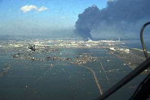
Ten percent of the world's active volcanoes—forty in the early 1990s (another 148 were dormant)—are found in Japan, which lies in a zone of extreme crustal instability. As many as 1,500 earthquakes are recorded yearly, and magnitudes of 4 to 7 are common. Minor tremors occur almost daily in one part of the country or another, causing slight shaking of buildings. Major earthquakes occur infrequently; the most famous in the twentieth century was the great Kantō earthquake of 1923, in which 130,000 people died. Undersea earthquakes also expose the Japanese coastline to danger from tsunamis (津波).
On March 11, 2011 Japan was subject to a devastating magnitude 9.0 earthquake and a massive tsunami as a result. The March 11 quake was the largest ever recorded in Japan and is the world's fourth largest earthquake to strike since 1900, according to the U.S. Geological Service. It struck offshore about 371 kilometres (231 mi) northeast of Tokyo and 130 kilometres (81 mi) east of the city of Sendai, and created a massive tsunami that devastated Japan's northeastern coastal areas. At least 100 aftershocks registering a 6.0 magnitude or higher have followed the main temblor. At least 15,000 people died as a result.
Japan has become a world leader in research on causes and prediction of earthquakes. The development of advanced technology has permitted the construction of skyscrapers even in earthquake-prone areas. Extensive civil defence efforts focus on training in protection against earthquakes, in particular against accompanying fire, which represents the greatest danger.
Another common hazard are several typhoons that reach Japan from the Pacific every year and heavy snowfall during winter in the snow country regions, causing landslides, flooding, and avalanches.
Regions
Japan is informally divided into eight regions. Each contains several prefectures, except the Hokkaidō region, which covers only Hokkaidō Prefecture.
The region is not an official administrative unit, but has been traditionally used as the regional division of Japan in a number of contexts: for example, maps and geography textbooks divide Japan into the eight regions, weather reports usually give the weather by region, and many businesses and institutions use their home region as part of their name (Kinki Nippon Railway, Chūgoku Bank, Tohoku University, etc.). While Japan has eight High Courts, their jurisdictions do not correspond to the eight regions.
Extreme points
This is a list of the extreme points of Japan, the points that are farther north, south, east or west than any other location.
Japan
- Northernmost point
- Benten-jima, Wakkanai, Hokkaidō – 45°31'35″N, 141°55'09″E
- Including land currently disputed with Russia: Cape Kamuiwakka (カムイワッカ岬 Kamuiwakka-misaki)), Etorufu – 45°33'N, 148°45'E
- Southernmost point: Okinotorishima – 20°25'N, 136°04'E
- Westernmost point: Yonaguni – 24°27′N, 122°59′E
- Easternmost point: Minami-Tori-shima – 24°18′N, 153°58′E
Japan (main islands)
- Northernmost point: Cape Sōya, Wakkanai, Hokkaidō – 45°31'N, 141°56'E
- Southernmost point: Cape Sata on Ōsumi Peninsula, Minamiōsumi, Kagoshima – 30°59'N, 130°39'E
- Westernmost point: Kōsakibana (神崎鼻), Sasebo (formerly Kosaza), Nagasaki – 33°13'N, 129°33'E
- Easternmost point: Cape Nosappu (納沙布岬 Nosappu-misaki)), Nemuro, Hokkaidō – 43°22'N, 145°49′E
Elevation extremes
- Lowest point: Hachirōgata – -4 m
- Highest point: Mount Fuji – 3,776 m
Antipodes
The only part of Japan with antipodes over land are the Ryukyu Islands, though the islands off the western coast of Kyūshū are close.
The northernmost antipodal island in the Ryukyu Island chain, Nakanoshima, is opposite the Brazilian coast near Capão da Canoa. The other islands south to the Straits of Okinawa correspond to southern Brazil, with Gaja Island being opposite the outskirts of Santo Antônio da Patrulha, Takarajima with Jua, Amami Ōshima covering the villages of Carasinho and Fazenda Pae João, Ginoza, Okinawa with Palmas, Paraná, the Kerama Islands with Pato Branco, Tonaki Island with São Lourenço do Oeste, and Kume Island corresponding to Palma Sola. The main Daitō Islands correspond to near Guaratuba, with Oki Daitō Island near Apiaí.
The Sakishima Islands beyond the straits are antipodal to Paraguay, from the Brazilian border almost to Asunción, with Ishigaki overlapping San Isidro de Curuguaty, and the uninhabited Senkaku Islands surrounding Villarrica.
See also
- Japanese addressing system
- List of islands of Japan
- List of lakes of Japan
- List of mountains and hills of Japan by height
- List of national parks of Japan
- List of peninsulas of Japan
- List of rivers of Japan
References
- ↑ Ministry of Foreign Affairs of Japan
- ↑ "離島の現状について" (PDF). Ministry of Land, Infrastructure, Transport and Tourism. Retrieved 2015-10-11.
- ↑ "Forest area". The World Bank Group. Retrieved 2015-10-11.
- ↑ "島とは何か". Center for Research and Promotion of Japanese Islands. Retrieved 2015-10-11.
- 1 2 "Japan granted more continental shelf". Upi.com. Retrieved 29 April 2012.
- ↑ "Japan Climate Charts Index". Retrieved 2015-10-11.
- ↑ "Yakushima World Heritage property". Ministry of the Environment. Retrieved 2015-10-11.
- ↑ "The length of the coast for the countries of the world". Retrieved 2015-10-11.
- ↑ Kochi Prefecture sees highest temperature ever recorded in Japan - 41 - Asahi Shimbun
- ↑ Annual Report on the Environment in Japan 2006, Ministry of the Environment
- All Geography of Japan information taken from the "Japan". The World Factbook. Central Intelligence Agency..
-
 This article incorporates public domain material from the Library of Congress Country Studies document "Japan".
External links
| Wikimedia Commons has media related to Geography of Japan. |
- "Colton's Japan: Nippon, Kiusiu, Sikok, Yesso and the Japanese Kuriles" a map from 1855
- Terrain of Japan - GJI Maps(Geospatial Information Authority of Japan)
Japan articles | |||||||||
|---|---|---|---|---|---|---|---|---|---|
| History |
|  | |||||||
| Geography | |||||||||
| Politics |
| ||||||||
| Economy | |||||||||
| Society | |||||||||