Clifton, Colorado
| Clifton, Colorado | |
|---|---|
| CDP | |
|
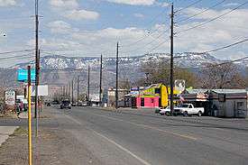
F Road (US Highway 6) in Clifton looking toward Grand Mesa. | |
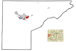 Location in Mesa County and the State of Colorado | |
| Coordinates: 39°4′39″N 108°27′51″W / 39.07750°N 108.46417°WCoordinates: 39°4′39″N 108°27′51″W / 39.07750°N 108.46417°W | |
| Country |
|
| State |
|
| County | Mesa County[1] |
| Government | |
| • Type | unincorporated community |
| Area | |
| • Total | 6.9 sq mi (17.8 km2) |
| • Land | 6.8 sq mi (17.6 km2) |
| • Water | 0.1 sq mi (0.2 km2) |
| Elevation[1] | 4,724 ft (1,440 m) |
| Population (2010) | |
| • Total | 19,889 |
| • Density | 2,513.8/sq mi (974.4/km2) |
| Time zone | MST (UTC-7) |
| • Summer (DST) | MDT (UTC-6) |
| ZIP Code | 81520[2] |
| Area code(s) | 970 |
| FIPS code | 08-15165 |
| GNIS feature ID | 0174618 |
Clifton is a census-designated place (CDP) in Mesa County, Colorado, United States. It is part of the Grand Junction Metropolitan Statistical Area. The population was 19,889 at the 2010 census.[3][4] The Clifton Post Office has the ZIP Code 81520.[2]
A post office called Clifton has been in operation since 1900.[5] The community was named for cliffs near the town site.[6]
Geography
Clifton is located at 39°4′39″N 108°27′51″W / 39.07750°N 108.46417°W (39.077631, -108.464219).[7]
According to the United States Census Bureau, the CDP has a total area of 6.8 square miles (18 km2), of which, 6.8 square miles (18 km2) of it is land and 0.1 square miles (0.26 km2) of it (1.17%) is water. Clifton lies in the warmest USDA hardiness zone in Colorado at 7a.
Demographics
| Historical population | |||
|---|---|---|---|
| Census | Pop. | %± | |
| 1910 | 1,126 | — | |
| 1920 | 1,105 | −1.9% | |
| 1930 | 1,246 | 12.8% | |
| 1940 | 1,712 | 37.4% | |
| 1950 | 1,396 | −18.5% | |
| 1960 | 1,935 | 38.6% | |
| 1970 | 3,554 | 83.7% | |
| 1980 | 3,847 | 8.2% | |
| 1990 | 7,378 | 91.8% | |
| 2000 | 12,238 | 65.9% | |
| 2010 | 19,889 | 62.5% | |
As of the census[4] of 2000, there were 17,345 people, 6,327 households, and 4,694 families residing in the CDP. The population density was 2,558.8 people per square mile (987.7/km²). There were 6,640 housing units at an average density of 979.5 per square mile (378.1/km²). The racial makeup of the CDP was 89.09% White, 0.55% African American, 1.42% Native American, 0.39% Asian, 0.05% Pacific Islander, 5.72% from other races, and 2.78% from two or more races. Hispanic or Latino of any race were 14.11% of the population.
There were 6,327 households out of which 42.0% had children under the age of 18 living with them, 52.8% were married couples living together, 15.7% had a female householder with no husband present, and 25.8% were non-families. 19.3% of all households were made up of individuals and 7.3% had someone living alone who was 65 years of age or older. The average household size was 2.73 and the average family size was 3.11.
In the CDP the population was spread out with 31.6% under the age of 18, 10.6% from 18 to 24, 30.6% from 25 to 44, 17.4% from 45 to 64, and 9.7% who were 65 years of age or older. The median age was 30 years. For every 100 females there were 92.9 males. For every 100 females age 18 and over, there were 88.3 males.
The median income for a household in the CDP was $31,684, and the median income for a family was $34,542. Males had a median income of $30,418 versus $20,704 for females. The per capita income for the CDP was $12,968. About 10.4% of families and 12.6% of the population were below the poverty line, including 16.9% of those under age 18 and 4.6% of those age 65 or over.
See also
References
- 1 2 "US Board on Geographic Names". United States Geological Survey. 2007-10-25. Retrieved 2008-01-31.
- 1 2 "ZIP Code Lookup". United States Postal Service. December 14, 2006. Archived from the original (JavaScript/HTML) on September 3, 2007. Retrieved December 14, 2006.
- ↑ Colorado Trend Report 2: State and Complete Places (Sub-state 2010 Census Data). Missouri Census Data Center. Accessed 2011-02-25.
- 1 2 "American FactFinder". United States Census Bureau. Archived from the original on 2013-09-11. Retrieved 2008-01-31.
- ↑ "Post offices". Jim Forte Postal History. Archived from the original on 6 March 2016. Retrieved 24 June 2016.
- ↑ Dawson, John Frank. Place names in Colorado: why 700 communities were so named, 150 of Spanish or Indian origin. Denver, CO: The J. Frank Dawson Publishing Co. p. 14.
- ↑ "US Gazetteer files: 2010, 2000, and 1990". United States Census Bureau. 2011-02-12. Retrieved 2011-04-23.
External links
| Wikimedia Commons has media related to Clifton, Colorado. |
Municipalities and communities of Mesa County, Colorado, United States | ||
|---|---|---|
| Cities |  | |
| Towns | ||
| CDPs | ||
| Unincorporated communities | ||
| Ghost towns | ||