Clemson, South Carolina
| Clemson, South Carolina | |
|---|---|
| City | |
|
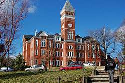
Top, left to right: Fort Hill, Tillman Hall at Clemson University, Memorial Stadium, College Avenue, Hanover House, Old Stone Church and Cemetery | |
| Nickname(s): Tigertown | |
| Motto: "In season, every season." | |
 Location of Clemson, South Carolina | |
| Coordinates: 34°41′6″N 82°48′53″W / 34.68500°N 82.81472°WCoordinates: 34°41′6″N 82°48′53″W / 34.68500°N 82.81472°W | |
| Country | United States |
| State | South Carolina |
| Counties | Pickens, Anderson |
| Area | |
| • Total | 7.9 sq mi (20.5 km2) |
| • Land | 7.5 sq mi (19.3 km2) |
| • Water | 0.5 sq mi (1.2 km2) |
| Elevation | 725 ft (221 m) |
| Population (2010) | |
| • Total | 13,905 |
| • Density | 1,869/sq mi (721.6/km2) |
| Time zone | Eastern (EST) (UTC-5) |
| • Summer (DST) | EDT (UTC-4) |
| ZIP codes | 29631-29634 |
| Area code(s) | 864 |
| FIPS code | 45-14950[1] |
| GNIS feature ID | 1247312[2] |
| Website |
www |

Clemson is a city in Pickens and Anderson counties in the U.S. state of South Carolina. Clemson is home to Clemson University; in 2015 the Princeton Review cited the town of Clemson as ranking #1 in the United States for "town-and-gown" relations with its resident university.[3] The population of the city was 13,905 at the 2010 census.[4]
Clemson is part of the Greenville-Spartanburg-Anderson, South Carolina Combined Statistical Area. Most of the city is in Pickens County, which is part of the Greenville-Mauldin-Easley Metropolitan Statistical Area. A small portion is in Anderson County, which is part of the Anderson Metropolitan Statistical Area.
History and background
The city of Clemson's character is largely defined by Clemson University, a large public university that dates to 1889. The university is the cultural center of the city, even though a small multi-block downtown with housing, retail and restaurants is directly to the north of the campus. The community was originally named Calhoun and was renamed Clemson in 1943.
Although the university provides housing for students, many students live off campus in a wide variety of apartment complexes. Save for the downtown, sidewalks are largely absent, but some streets have bike paths. U.S. Route 123 on the northern end of the city exhibits typical suburban-style shopping center developments. The city's comprehensive plan[5] has a historic preservation component which will likely become more important as 1950s and '60s buildings acquire historic status. The Clemson (train) Depot, built in 1893, was rehabilitated in 2001 and now houses the local chamber of commerce and visitor center.[6] A road project has closed the station as of 2016, with no known completion date. [7]
Clemson University was built on Fort Hill Plantation in 1889. This was home to John C. Calhoun and eventually became the home of Clemson University. Clemson University was built due to the influence of the women in succession of the Fort Hill Plantation. It all began with Floride, Calhoun’s wife, whose mother had originally purchased the estate. Floride became the owner of Fort Hill when her mother died in 1836. In the meantime, Floride and John C. Calhoun had a daughter named Anna Maria. Anna Maria eventually married Thomas Green Clemson at the age of 21. After their marriage, John C. Calhoun died in 1850 and allowed Floride Calhoun to gain total ownership of the Fort Hill Plantation. Because Anna Maria was the only living child, she inherited a part of Fort Hill when Floride died in 1866. Anna Maria gave Thomas G. Clemson a portion of the property in her will. When she died in 1875, he inherited the plantation. It was Anna Maria who wished to use the land to build an agricultural college, so when Thomas Green died in 1888, he left the land to build what is now known as Clemson University.
Geography and climate


Clemson is located at 34°41′6″N 82°48′53″W / 34.68500°N 82.81472°W (34.684930, −82.814777)[8] approximately 27 miles (43 km) west of downtown Greenville and 15 miles (24 km) north of Anderson. The city is situated near the western corner of South Carolina in the foothills of the Blue Ridge Mountains while also on the shores of Lake Hartwell.
According to the United States Census Bureau, the city has a total area of 7.9 square miles (20.5 km2), of which 7.5 square miles (19.3 km2) is land and 0.46 square miles (1.2 km2), or 5.85%, is water.[9]
Clemson has a humid subtropical climate characterized by warm, humid summers and cool, dry winters. Precipitation does not vary much throughout the seasons, except for the winter months when precipitation is infrequent. Clemson and the rest of the Upstate of South Carolina generally receives 1 to 3 inches (25 to 76 mm) of snow annually.
| Climate data for Clemson University, South Carolina | |||||||||||||
|---|---|---|---|---|---|---|---|---|---|---|---|---|---|
| Month | Jan | Feb | Mar | Apr | May | Jun | Jul | Aug | Sep | Oct | Nov | Dec | Year |
| Average high °F (°C) | 52 (11) |
56 (13) |
63 (17) |
72 (22) |
80 (27) |
87 (31) |
90 (32) |
90 (32) |
83 (28) |
73 (23) |
64 (18) |
54 (12) |
72 (22.2) |
| Average low °F (°C) | 30 (−1) |
32 (0) |
38 (3) |
45 (7) |
55 (13) |
65 (18) |
68 (20) |
69 (21) |
61 (16) |
49 (9) |
39 (4) |
32 (0) |
48.6 (9.2) |
| Average precipitation inches (mm) | 4.74 (120.4) |
4.81 (122.2) |
4.83 (122.7) |
3.56 (90.4) |
3.62 (91.9) |
3.67 (93.2) |
4.15 (105.4) |
4.94 (125.5) |
3.72 (94.5) |
3.69 (93.7) |
3.89 (98.8) |
4.78 (121.4) |
50.4 (1,280.2) |
| Source: The Weather Channel[10] | |||||||||||||
National Register of Historical Places
The following places and buildings in Clemson are listed on the National Register of Historic Places:
- Clemson University Historic District I and II
- Clemson College Sheep Barn
- Fort Hill (John C. Calhoun Mansion and Library)
- Hanover House
- Hopewell Plantation - Gen. Andrew Pickens' Home
- J. C. Stribling Barn
- Old Stone Church and Cemetery
Demographics
| Historical population | |||
|---|---|---|---|
| Census | Pop. | %± | |
| 1940 | 761 | — | |
| 1950 | 1,204 | 58.2% | |
| 1960 | 1,587 | 31.8% | |
| 1970 | 6,690 | 321.6% | |
| 1980 | 8,118 | 21.3% | |
| 1990 | 11,096 | 36.7% | |
| 2000 | 11,939 | 7.6% | |
| 2010 | 13,905 | 16.5% | |
| Est. 2015 | 15,446 | [11] | 11.1% |
As of the census[1] of 2000, there were 11,939 people, 5,061 households and 2,196 families residing in the city. The population does not reflect the additional on-campus population of Clemson University, which adds roughly 17,000 additional residents for eight months of the year.
The population density was 1,620.6 people per square mile (625.5/km²). There were 5,679 housing units at an average density of 770.8 per square mile (297.5/km²). The racial makeup of the city was 80.98% White, 11.38% African American, 5.73% Asian, 0.11% Native American, 0.03% Pacific Islander, 0.73% from other races, and 1.05% from two or more races. Hispanic or Latino of any race were 1.82% of the population.
There were 5,061 households, out of which 17.8% had children younger than 18 living with them, 35.2% were married couples living together, 5.9% had a female householder with no husband present and 56.6% were non-families. 28.6% of all households were made up of individuals and 7.7% had someone living alone who was 65 or older. The average household size was 2.30, and the average family size was 2.84.
In the city the population was spread out with 14.5% younger than 18, 36.8% from 18 to 24, 20.4% from 25 to 44, 15.5% from 45 to 64, and 12.7% who were 65 older. The median age was 25 years. For every 100 females. there were 106.4 males. For every 100 females age 18 and older, there were 107.5 males.
The median income for a household in the city was $26,892, and the median income for a family was $61,176. Males had a median income of $39,318 versus $28,663 for females. The per capita income for the city was $19,272. About 8.8% of families and 33.1% of the population were below the poverty line, including 13.1% of those under age 18 and 8.4% of those age 65 or over.
The 2010 census shows that Clemson’s population rose to 14,089 in 2012, showing an increase of 0.9% over two years and three months (from April 1, 2010 to July 1, 2012). The population in 2010 consisted of 5,823 households with an average of 2.33 people living in each household. This household quantity includes 2,474 family households, 932 of which had children younger than 18. 37% of these households were married couples, 2.3% male householder with no wife present and 3.2% female householders with no husband present. The rest of these households were composed of non-family households (57.5%) and householders living along (31.3%).
The city of Clemson had a population density of 1,869 persons per square mile. The total number of housing units in the city was 6.925. The overall racial distribution of the city was 78.4% white, 8.9% black or African American, 0.3% American Indian and Alaska Native, 8.3% Asian, and 2.2% Hispanic or Latino. The age distribution for Clemson is as follows: 4.1% under the age of 5 years, 3.3% 5–9 years, 4.4% 10–14 years, 4.3% 15–19 years, 32.6% 20–24 years, 14% 25–34 years, 8.8% 35–44 years, 8.8% 45-54, and 19.7% older than 55.
The median household income was $29,828 and the median family income was $77,704. The median earnings for a male worker (full-time) was $42,597, compared to the median earnings for a female worker (full-time), which was $32,524. The city of Clemson had a per capita income of about $23,906. 17.6% of the total population was below the poverty line, 13.2% of that total being families.[4]
Public safety
The city of Clemson operates with the Clemson Police Department, Clemson University Fire Department and Pickens County EMS, for public safety needs. All departments are staffed 24 hours a day, seven days a week. The Clemson University Fire Department has one station at 1521 Perimeter Road. The Police Department is at 1198 Tiger Boulevard. Pickens County EMS Medic 4 is at 115 Commons Way in Central.
Transportation
Clemson Area Transit (CAT) is a free transportation service that offers fare free service throughout the Clemson, Anderson, Pendleton and Seneca areas. All CAT buses are made accessible for patrons with disabilities and can accommodate any special needs. The CAT buses also provide transfer services to the local Electric City Transit bus in Anderson. Riders can receive vouchers from CAT bus operators in order to continue their ride fare-free on the Anderson shuttles.[13]
Clemson is also serviced by Greenlink shuttles that provides service to the Greenville Transit Authority Bus terminal.
The city of Clemson has an AMTRAK Station at the corner of Calhoun Memorial Highway and College Avenue.[14] The Crescent Route travels from New Orleans to New York City and stops through the Clemson station (CSN).[15] As of 2016, riders now have to take a shuttle to the Greenville Amtrak Station due to construction. [16]
The Clemson area is near three major airports. The closest, Greenville-Spartanburg International Airport, is 45 minutes away in Greenville, South Carolina. Hartsfield-Jackson Atlanta International Airport (ATL) is two and a half hours away in Atlanta, Georgia, and The Charlotte-Douglas International Airport (CLT) is two and a half hours away, as well, in Charlotte, North Carolina. Many different services provide transportation to and from the airport from the Clemson area, including The Airport Shuttle, Anderson/Clemson Shuttle Service, Yellow Cab and Andrews Airport Services.[17]
Education
The city of Clemson is in the school district of Pickens County. Children living in the city of Clemson attend Clemson Elementary School, RC Edwards Middle School and Daniel High School.[18]
Clemson Elementary School was originally called the Calhoun-Clemson School and was on College Avenue. In 1964, the school burned down, destroying everything but the cafeteria. The school was rebuilt on Frontage Road and was named Maggie Morrison Elementary School. The old building was renamed the Morrison annex and was used to house the primary grades. After the schools had outgrown their buildings, construction began in 1999 on a new school building on Berkeley Drive. This is now the site of the current Clemson Elementary. Clemson Elementary colors are orange and blue, and its mascot is the tiger cub.[19]
RC Edwards was built and opened in 1971. It currently educates sixth-, seventh- and eighth-graders. The campus is located between the cities of Central and Six Mile, and has about 800 students. Its colors are purple and white, and the mascot is the panther.[20]
The current D.W. Daniel High School was constructed in 2010 and had its first class enter the doors for the 2012-2013 school year. The school is named after David Wistar Daniel, a professor at Clemson University, who was invested in the public school system and spent many years on the South Carolina Board of Education. It recently was named one of the best regular public schools in the state by US News magazine. Its colors are blue and gold, and the mascot is the lion. The school is well known for its football team.[21] In the 2013-2014 season, the team ended the year 14 wins to one loss, which occurred in the 3A State Championship against Myrtle Beach High School.
City government
The city has a City Council and participates as a member of the Pickens County Council. Clemson’s senators in the United States Senate are Lindsey Graham and Tim Scott. In the House, Clemson’s representative is Jeff Duncan. The state senator is Thomas C. Alexander, and the state representative is B.R. Skelton.[22] Clemson City Council consists of an Arts and Culture Commission, a Planning Commission, a Board of Architectural Review and a Board of Zoning Appeals.[23]
The city of Clemson also works directly with the International Town Gown Association (ITGA) that works to provide information on common issues between universities and their neighboring towns. Two Clemson representatives serve on the ITGA Executive Board: Jim Oswald, ITGA Treasurer, and Beth Bagwell, ITGA Director.[24]
Attractions

In addition to Clemson University, the city is home to the South Carolina Botanical Garden, Fort Hill Plantation and Bob Campbell Geology Museum]. Lake Hartwell, a reservoir, is a popular recreation area that borders the city on the west. The Blue Ridge Mountains are located just 30 miles (48 km) from the city center. [25]
References
- 1 2 "American FactFinder". United States Census Bureau. Archived from the original on 2013-09-11. Retrieved 2008-01-31.
- ↑ "US Board on Geographic Names". United States Geological Survey. 2007-10-25. Retrieved 2008-01-31.
- ↑ https://www.princetonreview.com/college-rankings/best-colleges
- 1 2 "UNITED STATES QuickFacts from the US Census Bureau". Quickfacts.census.gov. Retrieved 2016-09-29.
- ↑ "Cultural Resources Goals and Objectives" (PDF). City of Clemson. Retrieved 2016-09-29.
- ↑ "Clemson, SC — Great American Stations". Greatamericanstations.com. 1990-07-26. Retrieved 2016-09-29.
- ↑ Clark Burns, Amy. "Q&Amy: Clemson Amtrak service to be interrupted". Greenville Online. Greenville Online. Retrieved 7 November 2016.
- ↑ "US Gazetteer files: 2010, 2000, and 1990". United States Census Bureau. 2011-02-12. Retrieved 2011-04-23.
- ↑ "Geographic Identifiers: 2010 Demographic Profile Data (G001): Clemson city, South Carolina". U.S. Census Bureau, American Factfinder. Retrieved August 7, 2013.
- ↑ "Average Weather for Clemson University, South Carolina". The Weather Channel. Retrieved 2011-12-03.
- ↑ "Annual Estimates of the Resident Population for Incorporated Places: April 1, 2010 to July 1, 2015". Census.gov. Retrieved July 12, 2016.
- ↑ "Census of Population and Housing". Census.gov. Archived from the original on May 11, 2015. Retrieved June 4, 2015.
- ↑ "Clemson Area Transit - General Info". Catbus.com. 2014-10-22. Retrieved 2016-09-29.
- ↑ "Stations - Clemson, SC (CSN)". Amtrak.com. Retrieved 2016-09-29.
- ↑ "Crescent - the Train between New York City and New Orleans". Amtrak. 2016-01-11. Retrieved 2016-09-29.
- ↑ Clarke Burns, Amy. "Q&Amy: Clemson Amtrak service to be interrupted". Greenville Online. Greenville Online. Retrieved 7 November 2016.
- ↑ "Transportation | City of Clemson, SC". Cityofclemson.org. Retrieved 2016-09-29.
- ↑ "Home - Pickens County School District". Pickens.k12.sc.us. 2016-09-24. Retrieved 2016-09-29.
- ↑ "Archived copy". Archived from the original on 2014-07-02. Retrieved 2014-03-12.
- ↑ "Archived copy". Archived from the original on 2013-11-03. Retrieved 2014-03-12.
- ↑ "Home - Daniel High School". Dhs.pickens.k12.sc.us. Retrieved 2016-09-29.
- ↑ "South Carolina Legislature Online - Find Your Legislators". Scstatehouse.gov. 2016-08-19. Retrieved 2016-09-29.
- ↑ "City Council Boards and Commissions | City of Clemson, SC". Cityofclemson.org. Retrieved 2016-09-29.
- ↑ "Mission And Vision | ITGA". Itgau.org. 2015-08-24. Retrieved 2016-09-29.
- ↑ "City of Clemson, SC | In Season, Every Season". Cityofclemson.org. Retrieved 2016-09-29.
External links
| Wikimedia Commons has media related to Clemson, South Carolina. |
-
 Clemson travel guide from Wikivoyage
 - City of Clemson official website
- Pickens County EMS
- Clemson information from Oconeecountry.com
Municipalities and communities of Anderson County, South Carolina, United States | ||
|---|---|---|
| Cities |  | |
| Towns | ||
| CDPs | ||
| Unincorporated communities | ||
| Footnotes | ‡This populated place also has portions in an adjacent county or counties | |
Municipalities and communities of Pickens County, South Carolina, United States | ||
|---|---|---|
| Cities | 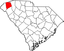 | |
| Towns | ||
| CDP | ||
| Unincorporated communities | ||
| Footnotes | ‡This populated place also has portions in an adjacent county or counties | |