Clearwater River (Idaho)
| Clearwater River (Kooskooskia) | |
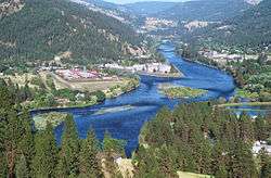
| Clearwater River near Greer Ferry | |
| Country | United States |
|---|---|
| State | Idaho |
| Regions | Idaho County, Clearwater County, Shoshone County, Nez Perce County |
| Part of | Snake River |
| Tributaries | |
| - left | South Fork Clearwater River |
| - right | Middle Fork Clearwater River, North Fork Clearwater River, Potlatch River |
| Cities | Orofino, Lewiston |
| Primary source | Middle Fork Clearwater River |
| - location | Confluence of Selway River and Lochsa River, Idaho County |
| - elevation | 1,453 ft (443 m) |
| - coordinates | 46°08′28″N 115°35′53″W / 46.14111°N 115.59806°W |
| Secondary source | South Fork Clearwater River |
| - location | Near Red River Hot Springs, Idaho County |
| - elevation | 4,285 ft (1,306 m) |
| - coordinates | 45°52′09″N 115°18′32″W / 45.86917°N 115.30889°W |
| Source confluence | Kooskia |
| - location | Idaho County |
| - elevation | 1,220 ft (372 m) |
| - coordinates | 46°08′45″N 115°58′56″W / 46.14583°N 115.98222°W |
| Mouth | Snake River |
| - location | Lewiston, Nez Perce County |
| - elevation | 741 ft (226 m) |
| - coordinates | 46°25′30″N 117°02′14″W / 46.42500°N 117.03722°WCoordinates: 46°25′30″N 117°02′14″W / 46.42500°N 117.03722°W |
| Length | 74.8 mi (120 km), Southeast-northwest [1] |
| Basin | 9,645 sq mi (24,980 km2) |
| Discharge | |
| - average | 15,300 cu ft/s (433 m3/s) |
| - max | 109,000 cu ft/s (3,087 m3/s) [2] |
|
Map showing the Clearwater River watershed
| |
The Clearwater River is a 74.8-mile-long (120.4 km)[1] river in north central Idaho, which flows westward from the Bitterroot Mountains along the Idaho-Montana border, and joins the Snake River at Lewiston. In October 1805, the Lewis and Clark Expedition descended the Clearwater River in dugout canoes, putting in at "Canoe Camp," five miles (8 km) downstream from Orofino.
By average discharge, the Clearwater River is the largest tributary of the Snake River. The River got its name for the Niimiipuutímt naming as Koos-Koos-Kai-Kai - “clear water”.
The drainage basin of the Clearwater River is 9,645 square miles (24,980 km2). Its mean annual discharge is 15,300 cubic feet per second (430 m3/s)[3]
Course
At the small town of Kooskia, the Middle Fork and South Fork of the Clearwater River join their waters to form the main stem of the Clearwater. The larger Middle Fork is made up of the combined flows of the Lochsa and Selway rivers which flow from the Bitterroot Mountains located to the east, while the much smaller South Fork originates in the Selway-Bitterroot Wilderness to the south. From the confluence the Clearwater flows northwest, passing the Heart of the Monster site of the Nez Perce National Historical Park. U.S. Route 12 follows the river to Kamiah, where it is joined by Lawyer Creek.
The river then continues northwest through a canyon to the confluence with Lolo Creek. It soon passes the town of Greer and receives Jim Ford Creek from the right. At Orofino the river gains the waters of Orofino Creek and swings westward in a nearly straight line for about 3 miles (4.8 km), then receives the North Fork Clearwater River from the right at Ahsahka close to Dworshak Reservoir. After the North Fork contributes its flow, the Clearwater trends west and receives Big Canyon Creek from the left, and Bedrock Creek from the right.
As the river canyon cuts deeper into the Columbia Plateau, the Clearwater passes the unincorporated communities of Lenore, Myrtle, where it receives Cottonwood Creek from the left and then Arrow, where it receives the Potlatch River from the right. Lapwai Creek joins from the left where the river passes close to Spalding. Here, U.S. Highway 95 crosses the Clearwater while Highway 12 continues running along the north shore. The river soon widens and slows into the slack water of Lower Granite Lake as it approaches Lewiston. Just as it crosses the Idaho-Washington state line, it joins its waters with the Snake River.
Tributaries
The Clearwater breaks into several separate forks:
- Clearwater River (west of Orofino to Lewiston-Snake River)
- Potlatch River (Latah, Clearwater and Nez Perce Counties)
- North Fork Clearwater River (stream, Clearwater County - 46°29′59″N 116°19′49″W / 46.49972°N 116.33028°W; headwaters near Illinois Peak to just west of Orofino)
- Little North Fork Clearwater River (stream, Shoshone & Clearwater Counties; headwaters in south-central Shoshone County, joins the North Fork in the Dworshak Reservoir)
- Middle Fork Clearwater River (stream, Idaho County - 46°08′43″N 115°58′56″W / 46.14528°N 115.98222°W; formed by the confluence of the Selway and Lochsa at Lowell)
- South Fork Clearwater River (stream, Idaho County - 46°08′44″N 115°58′56″W / 46.14556°N 115.98222°W; headwaters near Red River Hot Springs to Kooskia, confluence with the Middle Fork)
- Little Clearwater River (stream, Idaho County - 45°45′11″N 114°46′31″W / 45.75306°N 114.77528°W; near Three Prong Mountain to near Spot Mountain)
River modifications
The Dworshak Reservoir is the only major lake on the Clearwater system, created from the Dworshak Dam, completed in the early 1970s. Dworshak Dam is on the North Fork of the Clearwater River, and is just northwest of Orofino. There is no fish ladder; the dam blocks salmon and steelhead passage.
History
The border between Washington and Idaho was defined as the meridian running north from the confluence of the Clearwater River and the Snake River. Although this border is often referred to as the 117th meridian west longitude, the actual border line is slightly west (less than 2 miles) of the 117th meridian.[4]
See also
References
- 1 2 U.S. Geological Survey. National Hydrography Dataset high-resolution flowline data. "The National Map". Archived from the original on 2012-04-05., accessed May 3, 2011
- ↑ "USGS Gage #13343000 on the Clearwater River near Lewiston". National Water Information System. United States Geological Survey. Retrieved 2010-03-09.
- ↑ "Clearwater Subbasin Plan" (PDF)., Northwest Power and Conservation Council
- ↑ "Washington State Constitution". Arcticle XXIV Boundaries
External links
| Wikimedia Commons has media related to Clearwater River (Idaho). |
- "Clearwater River". Geographic Names Information System. United States Geological Survey., USGS GNIS