Clearwater County, Idaho
| Clearwater County, Idaho | ||
|---|---|---|
 | ||
| ||
 Location in the U.S. state of Idaho | ||
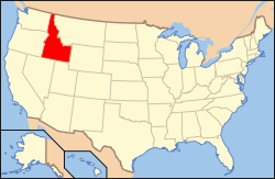 Idaho's location in the U.S. | ||
| Founded | February 27, 1911 | |
| Named for | Clearwater River | |
| Seat | Orofino | |
| Largest city | Orofino | |
| Area | ||
| • Total | 2,488 sq mi (6,444 km2) | |
| • Land | 2,457 sq mi (6,364 km2) | |
| • Water | 31 sq mi (80 km2), 1.2% | |
| Population | ||
| • (2010) | 8,761 | |
| • Density | 3.6/sq mi (1/km²) | |
| Congressional district | 1st | |
| Time zone | Pacific: UTC-8/-7 | |
| Website |
www | |
Clearwater County is a county located in the U.S. state of Idaho. As of the 2010 census, the population was 8,761.[1] The county seat is Orofino.[2] Established in 1911, the county was named after the Clearwater River.
The county is home to North Fork of the Clearwater River, and a small portion of the South Fork and the main Clearwater. Also in the county are the Dworshak Reservoir, Dworshak State Park, Dworshak National Fish Hatchery, and the Dworshak Dam, third highest dam in the U.S. The modest Bald Mountain ski area is located between Orofino and Pierce.
History
The Clearwater River and Lolo Pass, in the southeast corner of the county, were made famous by the exploration of Lewis and Clark in the early 19th century. Following an arduous trek through the Bitterroot Mountains, suffering through a mid-September snowstorm and near starvation, the Corps of Discovery expedition camped with the Nez Perce tribe on the Weippe Prairie outside of present-day Weippe in 1805. With the assistance of the Nez Perce, the expedition recuperated and constructed burned-out canoes at Canoe Camp in October 1805 and then paddled down the Clearwater, Snake, and Columbia rivers and met the Pacific Ocean a month later at present-day Astoria, Oregon.
Elias D. Pierce and Wilbur F. Bassett made the first discovery of gold in Idaho, on Orofino Creek (Canal Gulch) in 1860, 1 mile (2 km) north of present-day Pierce.
Until 1904, Clearwater County was part of Shoshone County to the north. It was annexed by Nez Perce County for several years and then was established as a new county in 1911.[3] The original county seat of Shoshone County was Pierce, in today's Clearwater County. It was the first gold rush area of present-day Idaho (then Washington Territory) in 1860 and was made the county seat of a vast Shoshone County in 1861, two years prior to the establishment of the Idaho Territory. When the Silver Valley population rose dramatically in the 1880s, the seat was moved to Murray in 1884 (and to Wallace in 1898) to better serve the majority of the county's population. The population of the southern area increased with homesteading in the Weippe area in the late 1890s. The vast distance and time required for travel to Wallace from the Clearwater River area prompted the move of the southern portion to Nez Perce County.
Geography

According to the U.S. Census Bureau, the county has a total area of 2,488 square miles (6,440 km2), of which 2,457 square miles (6,360 km2) is land and 31 square miles (80 km2) (1.2%) is water.[4] It is part of the Palouse, a wide and rolling prairie-like region of the middle Columbia basin.
Adjacent counties
- Shoshone County – north
- Latah County – west
- Nez Perce County – west
- Lewis County – southwest
- Idaho County – south
- Missoula County, Montana – east
- Mineral County, Montana – east
Major highways
National protected areas
- Clearwater National Forest (part)
- Mallard-Larkins Pioneer Area
- Lolo Trail National Historic Landmark (part)
- Nez Perce National Historical Park (part)
- Canoe Camp
- Musselshell Meadows
- Pierce Courthouse
- Weippe Prairie
- St. Joe National Forest (part)
Ski area
Government and infrastructure
The Idaho Department of Correction operates the Idaho Correctional Institution-Orofino in Orofino.[5][6]
Demographics
| Historical population | |||
|---|---|---|---|
| Census | Pop. | %± | |
| 1920 | 4,993 | — | |
| 1930 | 6,599 | 32.2% | |
| 1940 | 8,243 | 24.9% | |
| 1950 | 8,217 | −0.3% | |
| 1960 | 8,548 | 4.0% | |
| 1970 | 10,871 | 27.2% | |
| 1980 | 10,390 | −4.4% | |
| 1990 | 8,505 | −18.1% | |
| 2000 | 8,930 | 5.0% | |
| 2010 | 8,761 | −1.9% | |
| Est. 2015 | 8,496 | [7] | −3.0% |
| U.S. Decennial Census[8] 1790–1960[9] 1900–1990[10] 1990–2000[11] 2010–2013[1] | |||
2000 census
As of the census[12] of 2000, there were 8,930 people, 3,456 households, and 2,481 families residing in the county. The population density was 3.6 people per square mile (1.5/km²). There were 4,144 housing units at an average density of 2 per square mile (1/km²). The racial makeup of the county was 94.82% White, 0.15% Black or African American, 2.03% Native American, 0.37% Asian, 0.06% Pacific Islander, 0.63% from other races, and 1.96% from two or more races. 1.85% of the population were Hispanic or Latino of any race. 24.0% were of German, 14.0% English, 11.7% Irish and 10.5% American ancestry according to Census 2000.
There were 3,456 households out of which 28.90% had children under the age of 18 living with them, 60.50% were married couples living together, 6.90% had a female householder with no husband present, and 28.20% were non-families. 24.00% of all households were made up of individuals and 10.00% had someone living alone who was 65 years of age or older. The average household size was 2.41 and the average family size was 2.84.
In the county the population was spread out with 23.00% under the age of 18, 5.90% from 18 to 24, 26.30% from 25 to 44, 29.20% from 45 to 64, and 15.60% who were 65 years of age or older. The median age was 42 years. For every 100 females there were 113.40 males. For every 100 females age 18 and over, there were 115.90 males.
The median income for a household in the county was $32,071, and the median income for a family was $37,259. Males had a median income of $31,426 versus $21,694 for females. The per capita income for the county was $15,463. About 9.70% of families and 13.50% of the population were below the poverty line, including 18.90% of those under age 18 and 8.20% of those age 65 or over.
2010 census
As of the 2010 United States Census, there were 8,761 people, 3,660 households, and 2,397 families residing in the county.[13] The population density was 3.6 inhabitants per square mile (1.4/km2). There were 4,453 housing units at an average density of 1.8 per square mile (0.69/km2).[14] The racial makeup of the county was 93.9% white, 2.2% American Indian, 0.7% Asian, 0.2% black or African American, 0.1% Pacific islander, 0.8% from other races, and 2.1% from two or more races. Those of Hispanic or Latino origin made up 3.1% of the population.[13] In terms of ancestry, 29.3% were German, 17.8% were Irish, 13.8% were English, 6.7% were American, and 6.2% were Norwegian.[15]
Of the 3,660 households, 22.8% had children under the age of 18 living with them, 54.7% were married couples living together, 6.4% had a female householder with no husband present, 34.5% were non-families, and 29.3% of all households were made up of individuals. The average household size was 2.23 and the average family size was 2.71. The median age was 49.0 years.[13]
The median income for a household in the county was $41,835 and the median income for a family was $46,415. Males had a median income of $42,568 versus $30,048 for females. The per capita income for the county was $20,507. About 9.0% of families and 11.7% of the population were below the poverty line, including 14.7% of those under age 18 and 7.6% of those age 65 or over.[16]
Communities
Cities
Unincorporated communities
- Ahsahka
- Cardiff
- Cavendish
- Dent
- Grangemont
- Greer
- Headquarters
- Hollywood
- Judge Town
- Konkolville
- Moose City
- Teakean
Ghost town
See also
References
- 1 2 "State & County QuickFacts". United States Census Bureau. Retrieved June 28, 2014.
- ↑ "Find a County". National Association of Counties. Archived from the original on 2011-05-31. Retrieved 2011-06-07.
- ↑ clearwatercounty.org – about us – history – accessed 2011-12-11
- ↑ "US Gazetteer files: 2010, 2000, and 1990". United States Census Bureau. 2011-02-12. Retrieved 2011-04-23.
- ↑ "Locations." Idaho Department of Correction. Retrieved on June 4, 2011. "Idaho Correctional Institution-Orofino (ICIO) 381 West Hospital Drive Orofino ID 83544 "
- ↑ "Orofino city, Idaho." U.S. Census Bureau. Retrieved on June 4, 2011.
- ↑ "County Totals Dataset: Population, Population Change and Estimated Components of Population Change: April 1, 2010 to July 1, 2015". Retrieved July 2, 2016.
- ↑ "U.S. Decennial Census". United States Census Bureau. Archived from the original on May 11, 2015. Retrieved June 28, 2014.
- ↑ "Historical Census Browser". University of Virginia Library. Retrieved June 28, 2014.
- ↑ "Population of Counties by Decennial Census: 1900 to 1990". United States Census Bureau. Retrieved June 28, 2014.
- ↑ "Census 2000 PHC-T-4. Ranking Tables for Counties: 1990 and 2000" (PDF). United States Census Bureau. Retrieved June 28, 2014.
- ↑ "American FactFinder". United States Census Bureau. Archived from the original on 2013-09-11. Retrieved 2008-01-31.
- 1 2 3 "DP-1 Profile of General Population and Housing Characteristics: 2010 Demographic Profile Data". United States Census Bureau. Retrieved 2016-01-09.
- ↑ "Population, Housing Units, Area, and Density: 2010 – County". United States Census Bureau. Retrieved 2016-01-09.
- ↑ "DP02 SELECTED SOCIAL CHARACTERISTICS IN THE UNITED STATES – 2006–2010 American Community Survey 5-Year Estimates". United States Census Bureau. Retrieved 2016-01-09.
- ↑ "DP03 SELECTED ECONOMIC CHARACTERISTICS – 2006–2010 American Community Survey 5-Year Estimates". United States Census Bureau. Retrieved 2016-01-09.
External links
- Official website
- State of Idaho – Clearwater County
- Clearwater Museum – official site
- Idaho History.net – Pierce
- Idaho Mining.org – history
 |
Shoshone County | | ||
| Latah County and Nez Perce County | |
Missoula County, Montana and Mineral County, Montana | ||
| ||||
| | ||||
| Lewis County | Idaho County |
Municipalities and communities of Clearwater County, Idaho, United States | ||
|---|---|---|
| Cities | ||
| Unincorporated communities | ||
Coordinates: 46°40′N 115°40′W / 46.67°N 115.66°W