Claudelands
| Claudelands | |
|---|---|
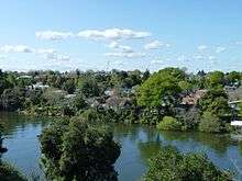 Claudelands, from Hamilton Central | |
| Basic information | |
| Local authority | Hamilton, New Zealand |
| Electoral ward | Hamilton East |
| Date established | 1912 |
| Population | 2421 (2013 Census) |
| Surrounds | |
| North | Fairfield |
| Northeast | Enderley |
| East | Hillcrest |
| South | Hamilton East |
| West | Hamilton Central |
Claudelands is a suburb directly to the east of central Hamilton, New Zealand, across the Waikato River. It is linked to the central city by the Claudelands road bridge and the East Coast Main Trunk Railway bridge.
History
Francis Richard Claude was an early wealthy settler who bought up parcels of mainly swampy land from the original soldier-settlers who were disgruntled with their land allocation. The only piece of land in near original state is the Kahikatea forest named Claudelands Bush adjacent to Claudelands showgrounds orininal. Originally the ground in this area was swampy but artificial drainage has dried the soil. The roots of the trees are protected by an elevated walkway which is open to the public.
Claudelands is one of the Hamilton's oldest suburbs, with a large number of bay villas and bungalows dating from the late 19th and early 20th centuries. Although later development led to the construction of a large number of two-storey blocks of flats, the unique character of the area was deemed worthy of preservation by the Hamilton City Council. To this end, strict rules governing alteration, demolition and new development were introduced. [1]
Features of Claudelands
Claudelands is home to the Claudelands Showgrounds - original site of major agricultural shows and events in Hamilton, and a trotting and dog racing track. Since passing into council ownership, a large part of it (including the race track) has been converted into a large open park. The upgraded Claudelands Arena was opened in 2011.
Claudelands is also home of one of Hamilton's oldest and most notable association football clubs, Claudelands Rovers.
Claudelands had a railway station from 1884 to 1991, named Hamilton East until 1899 and then Kirikiriroa until 1914.[2] It was between Brooklyn Rd and Claudelands Rd.[3] In 1912 Hamilton Chamber of Commerce applied for a porter to be employed there,[4] which was approved in 1913, when it became a tablet station.[5]
Demographics
According to the 2006 census, Claudelands has a population of 2385.[6] The Index of Socioeconomic Deprivation, ranked 1-10 from lowest to most deprived areas, lists Claudelands at 8/10 (high deprivation).[7]
| Year | Population | Households | Average income | NZ average | Waikato average |
|---|---|---|---|---|---|
| 2001 | 2,391 | 990 | $17,900 | $18,500 | $18,000 |
| 2006 | 2,382 | 987 | $25,600 | $24,400 | $24,100 |
| 2013 | 2,424 | 1,038 | $27,600 | $28,500 | $27,900[8] |
See also
References
- ↑ Taylor, Geoff (10 October 2009). "City plan aims to save old homes". Waikato Times. Fairfax New Zealand. Archived from the original on 20 September 2010. Retrieved 7 September 2010.
- ↑ Scoble, Juliet. "Names & Opening & Closing Dates of Railway Stations in New Zealand 1863 to 2010" (PDF). Rail Heritage Trust of New Zealand.
- ↑ Aerial photograph taken by Whites Aviation (4 Apr 1967). "Claudelands, Hamilton". Alexander Turnbull Library, Wellington.
- ↑ "Chamber Of Commerce.". Waikato Times. 1912-12-10. p. 4. Retrieved 2016-03-19.
- ↑ "Kirikiriroa Station.". New Zealand Herald. 1913-08-02. p. 7. Retrieved 2016-03-19.
- ↑ "Claudelands Quickstats". Retrieved 1 November 2010.
- ↑ "Index of Socioeconomic Deprivation for Areas within the Hamilton East Electorate". Parliament New Zealand. Retrieved 1 November 2010.
- ↑ "2013 Census map – QuickStats about a place". www.stats.govt.nz. Retrieved 2016-03-19.
External links
Coordinates: 37°46′43.27″S 175°17′13.64″E / 37.7786861°S 175.2871222°E