Clarksville City, Texas
| Clarksville City, Texas | |
|---|---|
| City | |
 Location of Clarksville City, Texas | |
 | |
| Coordinates: 32°31′44″N 94°53′40″W / 32.52889°N 94.89444°WCoordinates: 32°31′44″N 94°53′40″W / 32.52889°N 94.89444°W | |
| Country | United States |
| State | Texas |
| Counties | Gregg, Upshur |
| Area | |
| • Total | 6.5 sq mi (16.7 km2) |
| • Land | 6.3 sq mi (16.3 km2) |
| • Water | 0.2 sq mi (0.4 km2) |
| Elevation | 361 ft (110 m) |
| Population (2010) | |
| • Total | 865 |
| • Density | 127.9/sq mi (49.4/km2) |
| Time zone | Central (CST) (UTC-6) |
| • Summer (DST) | CDT (UTC-5) |
| ZIP code | 75693 |
| Area code(s) | 903 |
| FIPS code | 48-15172[1] |
| GNIS feature ID | 1332901[2] |
Clarksville City is a city in Gregg and Upshur Counties in the U.S. state of Texas. The population was 865 at the 2010 census.
Geography
Clarksville City is located at 32°31′44″N 94°53′40″W / 32.52889°N 94.89444°W (32.528866, -94.894344).[3]
According to the United States Census Bureau, the city has a total area of 6.5 square miles (16.8 km²), of which, 6.3 square miles (16.3 km²) of it is land and 0.2 square miles (0.4 km²) of it (2.47%) is water.
Demographics
| Historical population | |||
|---|---|---|---|
| Census | Pop. | %± | |
| 1960 | 359 | — | |
| 1970 | 398 | 10.9% | |
| 1980 | 525 | 31.9% | |
| 1990 | 720 | 37.1% | |
| 2000 | 806 | 11.9% | |
| 2010 | 865 | 7.3% | |
| Est. 2015 | 879 | [4] | 1.6% |
As of the census[1] of 2010, there were 865 people residing in the city. The population density was 127.9 people per square mile (49.4/km²). There were 337 housing units at an average density of 53.5 per square mile (20.7/km²). The racial makeup of the city was 92.56% White, 3.97% African American, 0.25% Native American, 0.62% from other races, and 2.61% from two or more races. Hispanic or Latino of any race were 1.36% of the population.
There were 302 households out of which 29.8% had children under the age of 18 living with them, 60.6% were married couples living together, 9.6% had a female householder with no husband present, and 25.5% were non-families. 24.2% of all households were made up of individuals and 11.3% had someone living alone who was 65 years of age or older. The average household size was 2.50 and the average family size was 2.95.
In the city the population was spread out with 24.1% under the age of 18, 7.9% from 18 to 24, 28.2% from 25 to 44, 28.4% from 45 to 64, and 11.4% who were 65 years of age or older. The median age was 39 years. For every 100 females there were 112.7 males. For every 100 females age 18 and over, there were 102.6 males.
The median income for a household in the city was $34,750, and the median income for a family was $38,523. Males had a median income of $30,078 versus $20,833 for females. The per capita income for the city was $15,888. About 11.0% of families and 11.0% of the population were below the poverty line, including 13.9% of those under age 18 and 8.1% of those age 65 or over.
History
Clarksville City is on U.S Highway 80 between Gladewater and White Oak in northeast Gregg County. The first settlers arrived in the area before 1845. There was a stagecoach stop at the home of William W. Walters, which was later owned and operated by Warren P. Victory. Though first known as Gilead, the post office was named Point Pleasant in 1852. It closed in 1867. The community withered when the railroad bypassed it in 1873 and Gladewater was established. With the advent of the East Texas oilfield in 1930, so many homes, businesses, and oil-company camps and offices sprang up along the highway that it was called the Main Street of Texas, and street numbers were designated from Longview to Gladewater. The area around George W. Clark's home on the site of the old stagecoach stop became known as Clarksville. After extensive paving projects and other civic improvements in the 1940s and the construction of Lake Gladewater in 1952, the nearby city of Gladewater had a high tax rate and was extending its boundaries. Industrialists in the area to the east became alarmed at the prospect of being taken into Gladewater and taxed more. A movement to incorporate, spearheaded by several oil companies and the L. W. Pelphrey Company, a general contractor specializing in oilfield construction, culminated in a vote to establish Clarksville City on September 14, 1956. Pelphrey was elected mayor and served until his death in August 1961. The bypassed portion of Old Highway 80 is named Pelphrey Drive in his honor. The population dwindled as drilling reached the state allowable and producing wells became automated. Cities Service Oil Company closed its office and camp in the early 1960s, and Sun Oil Company soon followed. After a population low of 359 in the 1960s, growth was steady. In 1990 Clarksville City had 720 residents and twenty businesses. In 2000 the population was 806. The town has an elected mayor and council with a city manager form of government. The city hall was built in 1962 and doubled in size in 1991. The area is in the Gladewater Independent School District. A Texas historical marker for the old community of Point Pleasant is at the city hall.[6]
Education
The City of Clarksville City is served by the Gladewater Independent School District.
External links
- Texas Municipal League - City of Clarksville City
- Texas Commission on Environmental Quality City of Clarksville City Water System Fact Sheet
References
- 1 2 "American FactFinder". United States Census Bureau. Archived from the original on 2013-09-11. Retrieved 2008-01-31.
- ↑ "US Board on Geographic Names". United States Geological Survey. 2007-10-25. Retrieved 2008-01-31.
- ↑ "US Gazetteer files: 2010, 2000, and 1990". United States Census Bureau. 2011-02-12. Retrieved 2011-04-23.
- ↑ "Annual Estimates of the Resident Population for Incorporated Places: April 1, 2010 to July 1, 2015". Retrieved July 2, 2016.
- ↑ "Census of Population and Housing". Census.gov. Archived from the original on May 11, 2015. Retrieved June 4, 2015.
- ↑ Mayer, Nauty. "CLARKSVILLE CITY, TX". Texas State Historical Association. Texas State Historical Association. Retrieved 24 April 2013.
Municipalities and communities of Gregg County, Texas, United States | ||
|---|---|---|
| Cities | 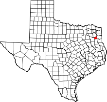 | |
| CDPs |
| |
| Other unincorporated communities | ||
| Footnotes | ‡This populated place also has portions in an adjacent county or counties | |
Municipalities and communities of Upshur County, Texas, United States | ||
|---|---|---|
| Cities |  | |
| Town | ||
| Unincorporated communities |
| |
| Footnotes | ‡This populated place also has portions in an adjacent county or counties | |