Claremont, Oakland/Berkeley, California
Coordinates: 37°51′21″N 122°14′58″W / 37.85583°N 122.24944°W
| Claremont | |
|---|---|
|
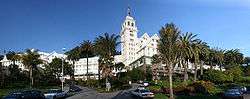
The Claremont Resort at the heart of the Claremont neighborhood | |
 Location of Claremont in the cities of Oakland and Berkeley | |
| Coordinates: 37°51′21″N 122°14′58″W / 37.855833°N 122.249444°W | |
| Country | United States |
| State | California |
| County | Alameda |
| Cities | Oakland and Berkeley |
The Claremont district is a neighborhood straddling the city limits of Oakland and Berkeley in the East Bay section of the San Francisco Bay Area in California, United States. It lies at an elevation of 266 feet (81 m). The main thoroughfares are Claremont and Ashby Avenues.
The name was given in the late 19th century by a real estate developer. Previously, the area was grazing land owned by a man named Harwood. Harwood's name was given to the canyon and the creek draining the canyon, previously shown on maps as the north fork of Temescal Creek. When a telegraph line was strung through this canyon, it was dubbed "Telegraph Canyon". A stage coach line ran up the canyon and over the summit into Contra Costa County. This became an early auto route over the Berkeley Hills until the first auto tunnel opened up in the 1910s at the top of Old Tunnel Road to the south of Claremont Canyon, above where the Caldecott Tunnel is today.
Today, Harwood's/Telegraph Canyon is Claremont Canyon, and North Fork Temescal/Harwood's Creek is Claremont Creek.
In the early 1900s real estate interests associated with the Key System built the Claremont Hotel at the mouth of Claremont Canyon. The Key System ran one of its commuter train lines directly to the hotel up Claremont Avenue until service ended in 1958. This train became the transbay "E" train upon completion of the San Francisco–Oakland Bay Bridge.
The principal west-east thoroughfare through the Claremont was at first Russell Street which led directly to the road up Claremont Canyon. With the opening of the tunnel however, Ashby became the more convenient approach to the Tunnel Road and was improved over the years to channel through traffic, being designated State Route 24 and connected to the Eastshore Highway (now Freeway) in southwest Berkeley. Upon completion of the Grove-Shafter Freeway, it was re-designated State Route 13.
The Claremont district was one of the areas affected by the 1991 Oakland firestorm. The flames came within a few blocks of the Claremont Hotel, destroying much of the area northeast of Tunnel Road.