Pescorocchiano
| Pescorocchiano | ||
|---|---|---|
| Comune | ||
| Comune di Pescorocchiano | ||
|
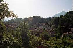
View of Torre di Taglio, a frazione of Pescorocchiano. | ||
| ||
 Pescorocchiano Location of Pescorocchiano in Italy | ||
| Coordinates: 42°12′N 13°9′E / 42.200°N 13.150°E | ||
| Country | Italy | |
| Region | Latium | |
| Province / Metropolitan city | Rieti (RI) | |
| Frazioni | Alzano, Castelluccio Baccarecce, Castagneta, Civitella di Nesce, Colle di Pace, Girgenti, Granara, Leofreni, Nesce, Pace, Petrignano, Poggio San Giovanni, Roccaberardi, Roccarandisi, Santa Lucia di Gioverotondo, Sant'Elpidio, Torre di Taglio | |
| Government | ||
| • Mayor | Mario Gregori | |
| Area | ||
| • Total | 94.6 km2 (36.5 sq mi) | |
| Elevation | 806 m (2,644 ft) | |
| Population (31 December 2010[1]) | ||
| • Total | 2,290 | |
| • Density | 24/km2 (63/sq mi) | |
| Demonym(s) | Pescorocchianesi | |
| Time zone | CET (UTC+1) | |
| • Summer (DST) | CEST (UTC+2) | |
| Postal code | 02024 | |
| Dialing code | 0746 | |
| Patron saint | St. Andrew the Apostle | |
| Saint day | 30 November | |
| Website | Official website | |

Pescorocchiano is a comune (municipality) in the Province of Rieti in the Italian region Latium, located about 60 kilometres (37 mi) northeast of Rome and about 30 kilometres (19 mi) southeast of Rieti.
Pescorocchiano borders the following municipalities: Borgorose, Carsoli, Collalto Sabino, Fiamignano, Marcetelli, Petrella Salto, Sante Marie, Tornimparte, Varco Sabino. It is located not far from the Lago del Salto and is a typical agricultural municipality, renowned for the production of chestnut. The frazione (separated hamlet) of Civitella di Nesce, was most likely the seat of the Res publica Aequiculorum, an ancient Roman municipium in the former territory of the Aequi.
References
External links
This article is issued from Wikipedia - version of the 2/1/2016. The text is available under the Creative Commons Attribution/Share Alike but additional terms may apply for the media files.