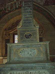
City of the Dead (Cairo)

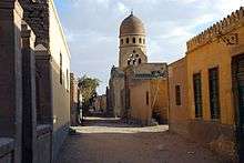

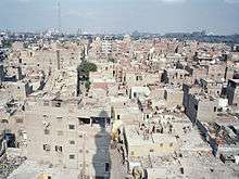

The City of the Dead, or Cairo Necropolis (Qarafa, el-Arafa), is an Islamic necropolis and cemetery below the Mokattam Hills in southeastern Cairo, Egypt. The people of Cairo, the Cairenes, and most Egyptians, call it el'arafa (trans. 'the cemetery'). It is a 4 miles (6.4 km) long (north-south) dense grid of tomb and mausoleum structures, where some people live and work amongst the dead. Some reside here to be near ancestors, of recent to ancient lineage. Some live here after being forced from central Cairo due to urban renewal demolitions and urbanization pressures, that increased from the Gamal Abdel Nasser era in the 1950s and forward. Other residents immigrated in from the agricultural countryside, looking for work — an example of rural to urban migration in an LEDC (least economically developed country). The poorest live in the City of the Dead slum, and Manshiyat Naser, which is also known as Garbage City, a center of recycling and reuse Zabbaleen vendors.
History
Caliphate era
The founding dates back to the Muslim conquest of Egypt in 642 AD. The Muslim Arab commander 'Amr ibn al-'As founded the first Islamic Egyptian capital, the city of Al Fustat, and established his family’s graveyard at the foot if the hill known as al Mokattam.The other families buried their dead within the living quarters. The following Islamic dynasties built their own political citadel to the north, founding a new graveyard. The commander’s family cemetery, the Great Qarafa and the Lesser Qarafa, have been inhabited since the first centuries after the conquest. Its first resident nucleus consisted of the custodians to nobles' graves and the staff in charge of the burial service as well as the Sufi mystics in their khawaniq (Sufi colleges).
During the Fatimid Caliphate, because of their Shi’ite faith, the sovereigns supported pilgrimages to Ahl al Bayt (Prophet’s family) shrines here. These pilgrimages increased the cemetery’s development to provide pilgrims’ needs. The following sultan, Salah el Din, in order to unify all the four capitals within a surrounding wall, included both cemeteries in a unique urban space.
Next, the Mamluk Sultanate rulers originally freed slaves forming a military caste, and founded a new graveyard named Sahara, because of its desert environment, outside the city at its north-eastern border. It was also a place for military parades, such as tournaments and investiture ceremonies, as well as for processions, at which sultan and nobles took part during the religious celebrations. Some built their palaces on the main road of the cemetery in order to assist to the spectacles.
Ottoman era
With the Ottoman Empire (1517–1802), Egypt became a province of a vast empire with Constantinople (Istanbul) as the capital. During the following three centuries Egypt was ruled by pashas, the sultans' representatives selected among their closest circle because of the importance of the province for agricultural and financial support. Because of the short terms of the rulers’ office, only a few of one hundred and ten pashas who administrated Ottoman Egypt had tombs here. The Cairenes were contrary to their burial abroad.
At the beginning of the sixteenth century an urban and heterogeneous community populated Al Qarafa. The economic improvements affected the urban territory of Islamic Cairo with the birth of new neighbourhoods which caused a reduction in the utilization of the old cemetery. However, since the funerary monuments were symbols of self-glorification for the upper classes in order to perpetuate own memory, their tombs were garlanded with gilded decorations with festoons, based on nature, flowers and fruits.
The necropolis, because a site of extraordinary concentration of awalya’s tombs, Sufi colleges, and madrasas, attracted many people in search of baraka (blessing). During the following centuries the Egyptian population's impoverished numbers increased. The lower stratum of middle class collapsed and moved to other peripheral zones, the fellahin, the Egyptian peasants and farmers, emigrated to the capital. Both of them crowded the poorest fringe zones as well as the City of the Dead. The newcomers changed Al Qarafa’s face from an urban district to a hybrid community of rurals and citizens.
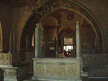
List of prominent shrines
1) Al Husayn: Muhammad's grandson.
2) Sayyida Zaynab: Cairo's second most popular saint, the sister of the martyred al-Husayn.
3) Sheikh Ali: a sheikh with a reputation for miracles.
4) Al- Salih Ayyub: the last of the major Ayyubid sultans.
5) Shagar al- Durr: the widow of Al- Salih Ayyub who played the role of the sultana at the start of the Mamuluk's era.
6) Other female shrines: the female saints; Nafisa, Ruqqaya, Atika and Sukayna.
Recent history
Following the 1992 Cairo earthquake, many people were forced to move into family tombs thus adding to the number of people already living in the City of the Dead.[1]
The neighborhood has been characterized as a slum. Its current population may exceed half a million people.[2][3]
Following the January 25 revolution, there has reportedly been a rise in criminal activities in the poorly maintained streets connecting the tombs. Residents of the City of the Dead say that the crime rate there has increased, with drug trafficking taking place inside some of the mausoleums. During Nasser's presidency in the 1960s, rapid urbanization and the modernization of industries in and around Cairo lead to a massive migration that the city was ill-equipped to handle.[4] Recently, living conditions have improved as many graves now have running water and electricity. In addition to that, some parts have apartment blocks, a medical center and a post office. Two schools have also been built during Hosni Mubarak's rule. Many believe that living besides the shrines of the deceased is a blessing that will bring a divine reward, while others wish to be close to their ancestors.
Historic tours
The City of the Dead has been frequented by visitors throughout history. Ibn Battuta is among the notable travelers who made it here, giving a brief description of the City of the Dead in his travelogue.
Festivals
Mawlid of Zaynab bint Ali.[5]
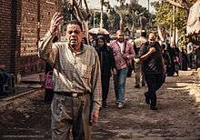
Though Islam does not have traditional saints as in other Abrahamic religions, walis are often considered the equivalent of this post-mortem honor. Like the mawlid of the Islamic prophet Muhammad, the birth of some of the walis are celebrated by people in the City of the Dead. Grand festivals are held with the purpose of celebrating the birth of these "saint-like" people as well as obtaining their Barakah or blessing. Zaynab bint Ali was one such figure.
Zaynab bint Ali was the granddaughter of the Muhammad by Ali ibn Abi Talib and Fatima bint Muhammad as well as sister of Husayn ibn Ali. Due to her connection to both Muhammed and Husayn ibn Ali, her mawlid has elements of both Sunni and Shia traditions of Islam, as well as the music and dhikr of the Sufi tradition. On this night, called the Big Night (elleila elkebeera), different tents of color-patterned marquees are put up for the occasion.
References
- ↑ Tozzi Di Marco A. Il Giardino di Allah. Storia della necropoli musulmana del Cairo. Ananke edizioni 2008
- ↑ Qarafa, City of the Dead, Cairo, Egypt - Things to Do Reviews | NileGuide
- ↑ Mike Davis: Planet der Slums, Assoziation A, Berlin, 2007, p. 32
- ↑ "Meet The Egyptian Families Who Live Among The Tombs In Cairo's Massive Cemetery". Retrieved 2015-04-22.
- ↑ Rodenbeck, Max. Cairo: the city victorious. Vintage Departures.
- Bibliography
- Hamza, Hani. The Northern Cemetery of Cairo Cairo: The American University in Cairo Press, 2001. ISBN 977-424-618-7.
External links
Coordinates: 30°02′48″N 31°16′35″E / 30.04667°N 31.27639°E