City of London Cemetery and Crematorium
|
The Main Gate and Sign | |
| Details | |
|---|---|
| Established | 1856 |
| Location | London Borough of Newham, London |
| Country | England |
| Coordinates | 51°33′28″N 0°02′40″E / 51.55782°N 0.04432°E |
| Type | Public |
| Size | 200 acres (81 ha) |
| Number of graves | 150,000+ |
| Number of interments | approaching 1 million |
| Website | Official website |

The City of London Cemetery and Crematorium is a cemetery and crematorium in the north east of London. It is the largest such municipal facility in the UK and probably in Europe.[1]
It is owned and operated by the City of London Corporation.
It is designated Grade I on the Historic England National Register of Historic Parks and Gardens. Anyone may be interred at the City of London Cemetery irrespective of city connections or religious beliefs.[2] At the City of London Cemetery and Crematorium, they reuse old graves which have not been used for more than 75 years, and which are known to have depth for at least two more burials. English Heritage has listed many burial grounds and says it has no objection to the reuse of graves in principle, as long as heritage is protected.[3]
Location
The cemetery is located on the east side of Aldersbrook Road, in Manor Park, in the London Borough of Newham, near Epping Forest. It has two entrances, the Main Gate, which is located close the junction of Forest Drive and the Aldersbrook Road. There is a small gate on the junction with Rabbits Road, called the South Gate.
History
In 1849 William J. Haywood, Chief Engineer of the City of London Commission of Sewers, reported on the condition of the city's churchyards and their health risks. The Commissioners were responsible for public hygiene and sanitation and were in effect also the burial board for the City of London, due to an Act of Parliament in 1852. The commissioners directed that a cemetery be built for the city's 106 parishes, to replace intramural interment (burial within the confines of a parish). The task was taken up by William Haywood and Dr John Simon.
In 1853 this led to the purchase of land owned by the 2nd Duke of Wellington. The 200 acres (0.81 km2) of land suited the construction of the cemetery because it was accessible (only 7 miles (11 km) to the centre of the City of London), had attractive planting and porous, gravelly, well drained soil. This former farm land was sold to the Corporation for £30,721 and the cemetery was founded in 1854. It was laid out in 1855 by William Haywood, who designated 89 acres (360,000 m2) for burial but also reserved land for plots sold in perpetuity, buildings, landscaping and roads. He was helped by landscape gardener Robert Davidson.[4] In selecting planting, Haywood and Simon were guided by John Claudius Loudon's On the Laying Out, Planting, and Managing of Cemeteries (1843). The total cost is estimated at over £45,000, which is approximately £26,000 more than originally planned.
The first interment was on 24 June 1856, although the cemetery was not consecrated until November 1857, due to legal difficulties (which were solved in the Burial Act 1857). It is estimated that in 1858 around 2,700 interments took place. Approximately 600,000 people have been interred here and with the remains from over 30 London Church yards also placed on the site, the figure is approaching 1 million.[5]
Facilities
The cemetery has many different burial sites. It also has a number of chapels. At the beginning of the 20th century a crematorium was built (designed by D.J. Ross), at a cost of around £7,000 and was opened on October 25, 1904 in the presence of Sir Henry Thompson. There are now two crematoria, designated the Old and the New. The old crematorium is no longer in use as a crematorium but is still used as a chapel. The new crematorium is a modern symmetrical building (1971, designed by E.G. Chandler) containing two separate crematoria (each having two cremators). There is also a chapel of remembrance and a Columbarium. The cemetery is one of only a few cemeteries in London with catacombs. This however has proven to be an unpopular method of burial, part of the unused catacombs have now been converted into columbarium space.
In 1937 a garden of rest was constructed, followed by a series of memorial gardens (there are an estimated 20,000 rose bushes in this area alone).
Today
The cemetery and crematorium are still open, although the cemetery is reaching capacity. There are now in excess of 150,000 gravesites and new burials have begun to be placed atop older burials, leaving deep interments undisturbed.[6] This is done very sensitively, involving experts and the family of the deceased (if known).
Today, the cemetery and crematorium are non-denominational, but originally there was an Anglican chapel, with a 61 ft (19 m) spire and an unusual round Dissenter's chapel (designed by William Haywood).
There are 729 identified Commonwealth service personnel of both World Wars commemorated at the cemetery, many buried in a War Graves plot, which has a Cross of Sacrifice and a Screen Wall memorial that lists casualties who are buried in the plot or elsewhere in the cemetery without headstones, besides those cremated at the City of London Crematorium. Many of the soldiers died at the Bethnal Green Military Hospital.[7]
Historical Importance
The cemetery grounds have been listed Grade I on the Historic England National Register of Parks and Gardens.[8] Eight Grade II listed buildings on the National Heritage List for England are also associated with the cemetery, these are the Main Entrance Screen and Lodges,[9] the Non Conformist Mortuary Chapel,[10] the Columbarium,[11] the Monument at the South End of the Columbarium and Non Conformist Chapel,[12] the monument to William Haywood,[13] the cottage,[14] and the Central Avenue chapel and the South Chapel[15][16]
The cemetery is also interesting because it has been in continuous use since its opening. The social attitude towards the afterlife is reflected in the way the cemetery is laid out, ranging from Victorian to contemporary. Many of the churches that were demolished in London had their dead reinterred in the City of London Cemetery (see Reburial and memorials section).
Reburial and memorials
The Union of Benefices Act 1860 allowed for the demolition of many unused City churches, and for the reinterment of the remains in the City of London Cemetery. The cemetery also contains inhumations from London churches destroyed during the Blitz.
- St Benet Gracechurch (1865)
- All Hallows Staining (1870)
- St Andrew and St Sepulchre (1871), this Grade II listed grand monument was designed by Haywood [17]
- St Mary Somerset (1871)
- Holy Trinity the Less (1872)
- St Mildred, Poultry, the church was demolished in 1872, the parish was joined with St Olave
- St James Duke's Place (1874)
- St Martin Outwich (1874)
- St Antholin, Watling Street (1875)
- All Hallows Bread Street (1878)
- St Dionis Backchurch (1878)
- St Matthew Friday Street (1884)
- St Olave (1887)
- St Helen's Bishopsgate (1892)
- St Mary Magdalen Old Fish Street, destroyed by a fire in 1886 and demolished in 1893
- St Mary Woolnoth (between 1897–1900), the contents of the crypt were moved here because of the construction of the Bank Station under the church.
- St Peter le Poer, the church was demolished in 1907, the parish was joined with St Michael, Cornhill
- St Alphage London Wall (1924)
- St Katherine Coleman (1925)
- All Hallows Lombard Street (1939)
- Holy Trinity, Minories (1940)
- St Alban, Wood Street (1940)
- St Mary Aldermanbury (1940), the church was rebuilt in Fulton, Missouri, USA, in 1966
- St Botolph's Aldgate, the remains of around 2,500 persons were moved here when the north part of the churchyard was cleared in 1965
- St Michael Queenhithe, the church was demolished in 1876, reinterment took place in 1969
- St Michael, Cornhill, reinterment from the churchyard (date unknown)
Some churches were destroyed in the Great Fire of London in 1666 and never rebuilt due to the Rebuilding Act. Many were joined with other parishes. Their churchyards were either left, moved to a new location or to this cemetery (sometimes at a later date). Among these were:
- St Dionis Backchurch
- St John the Evangelist, Watling Street, the churchyard was cleared in 1954
- St John Zachary
- St Leonard, Eastcheap, the churchyard on Fish Street Hill was cleared in 1882
- St Martin Pomary
- St Martin Vintry
- St Mary Colechurch
- St Mary Woolchurch Haw, the churchyard was cleared in 1892
- St Peter, Paul's Wharf
And of course:
- French Hospital memorial
Notable burials
- Michael Barrett, a Fenian
- Robert Bentley and Charles Tucker, policemen victims of the Battle of Stepney
- George Leslie Drewry VC, British sailor in the Royal Navy Reserve, accidentally killed at Scapa Flow 1918
- Catherine Eddowes and Mary Ann Nichols; victims of Jack the Ripper
- Elizabeth Everest (d.1895), Winston Churchill's nanny
- George William Foote, a secularist and journal editor
- Alfred Horsley Hinton, a pictorialist photographer
- Robert Hunter (encyclopædist)
- Elwyn Jones, a British barrister and Labour politician
- Rev Alexander McCaul
- Dame Anna Neagle, a popular English stage and motion picture actress and singer and her husband Herbert Wilcox a British film director and producer of films such as The Courtneys of Curzon Street and Odette.
- Sir James Roll, Lord Mayor of London
- William Saunders (1825-1901), Medical Officer of Health to the City of London
- John Joseph Sims VC, British foot Soldier (died 1881)
- Rev Thomas Bowman Stephenson, founder of the National Children's Homes
- Percy Thompson, murder victim, see Edith Thompson and Frederick Bywaters
- Sir Walter Wilkin (1842-1922), Lord Mayor of London 1895-6
People reputed to have been reinterred here.
- Claude Duval (1643–1670), highwayman, although he was originally buried in St Paul's, Covent Garden
- Robert Hooke (1635–1703), scientist, although he was originally buried in St Helen's Bishopsgate
Other last resting places.
- Bobby Moore, footballer, was cremated at Putney Vale Crematorium, but his ashes rest in the Garden of Remembrance.
- Veronica Foley, aka Ronnie, Stage and Television actress & drama teacher, from the Sylvia Young Theatre School.
Gallery
 Cemetery gates
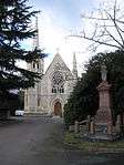 Anglican Chapel
 Dissenters Chapel
 Columbarium and Catacombs
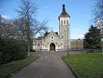 The Old Crematorium
 The New Crematorium
 View down Central Avenue
 View of new graves
 The Vigiland Memorial
 Hindu monument
Visiting
The City of London Cemetery and Crematorium is open 365 days per year and offers beautiful formal gardens, well maintained roadways, over 3,500 mature trees and the local heritage for the last 150 years within a well maintained rolling landscape. The Cemetery and Crematorium offers its visitors uniformed information staff, a florist shop and a tea room with its own garden and even a free weekend bus service.[18]
The City of London Cemetery and Crematorium is maintained to a very high standard, and has been awarded the Green Flag Award.[19]
Transport
There are a number of ways to get to the cemetery using public transport.
- There are two National Rail stations in the vicinity: Manor Park and Ilford.
- The London Underground: East Ham
- The London Overground: Woodgrange Park
- Bus: W19, 25, 86 and 101 (there is a bus stop at the main gate).
References
- ↑ City of London Cemetery and Crematorium (LB Newham Archives) accessed 11 January 2009
- ↑ http://www.cityoflondon.gov.uk/Corporation/LGNL_Services/Community_and_living/Deaths_funerals_and_cremations/Cemetery_and_crematorium/
- ↑ "Reuse of graves 'needed to prevent crisis'". BBC News. 15 May 2011.
- ↑ Web booklet on Cemeteries by English Heritage (2003)
- ↑ http://www.cityoflondon.gov.uk/Corporation/LGNL_Services/Community_and_living/Deaths_funerals_and_cremations/Cemetery_and_crematorium/burial_registers.htm
- ↑ Walker, Blair S. (1 December 2009), "Stacking Up the Departed in London", AARP Bulletin, In the News, AARP Publications, 50 (10), p. 8, ISSN 1044-1123, archived from the original on 18 December 2009, retrieved 18 December 2009
- ↑ CWGC Cemetery Report.
- ↑ Historic England, "City of London Cemetery (1000286)", National Heritage List for England, retrieved 11 February 2016
- ↑ Historic England, "Main Entrance Screen and Lodges at City of London Cemetery (1080984)", National Heritage List for England, retrieved 11 February 2016
- ↑ Historic England, "Non Conformist Mortuary Chapel East End of Chapel Avenue at City of London Cemetery (1080985)", National Heritage List for England, retrieved 11 February 2016
- ↑ Historic England, "Columbarium at City of London Cemetery (1080986)", National Heritage List for England, retrieved 11 February 2016
- ↑ Historic England, "Monument at southeEnd of Axis at south end of Axis South from Columbarium and Non Conformist Chapel at City of London Cemetery (1000286)", National Heritage List for England, retrieved 11 February 2016
- ↑ Historic England, "Mausoleum to Lieutenant Colonel W. Haywood at City of London Cemetery (1190633)", National Heritage List for England, retrieved 11 February 2016
- ↑ Historic England, "Cottage at City of London Cemetery (1293711)", National Heritage List for England, retrieved 11 February 2016
- ↑ Historic England, "Chapel (Central Avenue) City of London Cemetery (1357988)", National Heritage List for England, retrieved 11 February 2016
- ↑ Historic England, "South Chapel City of London Cemetery (1357999)", National Heritage List for England, retrieved 11 February 2016
- ↑ "Monument at South End of Axis at South End of Axis South from Columbarium and Non Conformist Chapel , Newham". www.britishlistedbuildings.co.uk. Retrieved 7 April 2013.
- ↑ http://www.keepbritaintidy.org/GreenFlag/GreenFlagAwardSites/London/Default.aspx?parkID=456
- ↑ City of London Cemetery and Crematorium (Green Flag Award winners) accessed 11 January 2009
Further reading
- Beach, Darren, London's Cemeteries, Metro Guides, 2006.
- Meller, Hugh & Brian Parsons, London Cemeteries: an illustrated guide and gazetteer, The History Press, 2008.
- Francis, Doris with Leonie Kellaher and Georgina Neophytou, The Secret Cemetery, Berg Publishers, 2005
External links
| Wikimedia Commons has media related to City of London Cemetery and Crematorium. |
Coordinates: 51°33′36″N 0°02′53″E / 51.560°N 0.048°E