City of Hawthorn
| City of Hawthorn Victoria | |||||||||||||
|---|---|---|---|---|---|---|---|---|---|---|---|---|---|
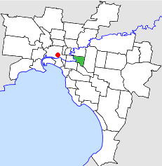 Location in Melbourne | |||||||||||||
 Hawthorn Town Hall | |||||||||||||
| Population | 31,500 (1992)[1] | ||||||||||||
| • Density | 3,244/km2 (8,402/sq mi) | ||||||||||||
| Established | 1860 | ||||||||||||
| Area | 9.71 km2 (3.7 sq mi) | ||||||||||||
| Council seat | Hawthorn | ||||||||||||
| Region | Melbourne | ||||||||||||
| County | Bourke | ||||||||||||
 | |||||||||||||
The City of Hawthorn was a local government area about 4 kilometres (2.5 mi) east of Melbourne, the state capital of Victoria, Australia, on the southeast bank of the Yarra River. The city covered an area of 9.71 square kilometres (3.75 sq mi), and existed from 1860 until 1994.
History
Hawthorn was incorporated as a municipal district on 27 July 1860. It was proclaimed as a town on 18 March 1887, and a city on 12 September 1890.[2]
On 22 June 1994, the City of Hawthorn was abolished, and, along with the Cities of Camberwell and Kew, was merged into the newly created City of Boroondara.[3]
The council met at the Hawthorn Town Hall, at the corner of Burwood and Glenferrie Roads, near Glenferrie railway station, Hawthorn. The facility is still used by the City of Boroondara as a regional arts centre.[4]
Wards
The City of Hawthorn was divided into four wards on 1 October 1923, each electing three councillors:
- Auburn Ward
- Glenferrie Ward
- Power Ward
- Yarra Ward
Geography
The council area covered the suburbs of Hawthorn, Hawthorn East and parts of Glen Iris, and was bounded by the Yarra River to the west, Barkers Road to the north, Gardeners Creek and CityLink (formerly South Eastern Freeway) to the south and Burke Road to the east.[5]
Population
| Year | Population |
|---|---|
| 1861 | 2,342 |
| 1881 | 6,019 |
| 1891 | 19,585 |
| 1947 | 40,464 |
| 1954 | 37,188 |
| 1958 | 35,700* |
| 1961 | 36,707 |
| 1966 | 36,717 |
| 1971 | 37,571 |
| 1976 | 32,505 |
| 1981 | 30,689 |
| 1986 | 29,623 |
| 1991 | 30,006 |
* Estimate in the 1958 Victorian Year Book.
See also
References
- ↑ Australian Bureau of Statistics, Victoria Office (1994). Victorian Year Book. p. 49. ISSN 0067-1223.
- ↑ Victorian Municipal Directory. Brunswick: Arnall & Jackson. 1992. pp. 393–394. Accessed at State Library of Victoria, La Trobe Reading Room.
- ↑ Australian Bureau of Statistics (1 August 1995). Victorian local government amalgamations 1994-1995: Changes to the Australian Standard Geographical Classification (PDF). Commonwealth of Australia. p. 4. ISBN 0-642-23117-6. Retrieved 2007-12-16.
- ↑ "Mayor introduces Hawthorn's new leading lady of the arts". City of Boroondara. Retrieved 18 March 2014.
- ↑ Melway - Greater Melbourne Street Directory (22nd edition). Glen Iris, Victoria: Melway Publishing Pty Ltd. 1993. pp. Maps 44–45, 58–59. ISSN 0311-3957.
Coordinates: 37°49′18″S 145°02′12″E / 37.8216°S 145.0367°E