City of Greater Geelong
| City of Greater Geelong Victoria | |||||||||||||
|---|---|---|---|---|---|---|---|---|---|---|---|---|---|
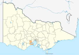 Location of the City of Greater Geelong in Victoria | |||||||||||||
 Geelong Town Hall, 2007 | |||||||||||||
| Population | 229,420 (2015)[1] (12th) | ||||||||||||
| • Density | 183.98/km2 (476.50/sq mi) | ||||||||||||
| Established | 1993 | ||||||||||||
| Gazetted | 18 May 1993[2] | ||||||||||||
| Area | 1,247 km2 (481.5 sq mi) | ||||||||||||
| Chairperson | Dr Kathy Alexander | ||||||||||||
| Council seat | Geelong city centre | ||||||||||||
| Region | Barwon South West | ||||||||||||
| State electorate(s) | |||||||||||||
| Federal Division(s) | |||||||||||||
|
| |||||||||||||
| Website | City of Greater Geelong | ||||||||||||
| |||||||||||||
The City of Greater Geelong is a local government area in the Barwon South West region of Victoria, Australia, located in the western part of the state. It covers an area of 1,247 square kilometres (481 sq mi) and, at the 2011 Census, had a population of 210,875.[3] It is primarily urban with the vast majority of its population living in the Greater Geelong urban area, while other significant settlements within the LGA include Anakie, Balliang, Barwon Heads, Batesford, Ceres, Clifton Springs, Drysdale, Lara, Ocean Grove, Portarlington and St Leonards. It was formed in 1993 from the amalgamation of the Rural City of Bellarine, Shire of Corio, City of Geelong, City of Geelong West, City of Newtown, City of South Barwon, and parts of Shire of Barrabool and Shire of Bannockburn.[2]
The City is governed and administered by the Greater Geelong City Council; its seat of local government and administrative centre is located at the council headquarters in Geelong, it also has service centres located in Drysdale, Ocean Grove and several other locations within Geelong. The City is named after the main urban settlement located in the centre-west of the LGA, that is Geelong, which is also the LGA's most populous urban centre with a population of 143,921.[4]
History of former municipalities
- 1838 – Geelong (Aboriginal word for 'Ocean') region declared a town
- 1849 – Geelong incorporated as a town
- 1853 – Barrabool declared a road district
- 1854 – Bellarine declared a road district
- 1857 – South Barwon a separate district
- 1858 – Newtown and Chilwell a borough
- 1862 – Bannockburn a road district
- 1863 – Queenscliff and Point Lonsdale separates from Bellarine to form the Borough of Queenscliffe
- 1863 – South Barwon a borough
- 1864 – Corio and Bannockburn made shires
- 1865 – Bellarine a shire
- 1872 – South Barwon a shire
- 1875 – West Geelong a borough
- 1910 – Geelong a city
- 1915 – Meredith added to Bannockburn Shire
- 1922 – West Geelong a town
- 1924 – Newtown and Chilwell a town
- 1929 – West Geelong a city
- 1959 – Newtown and Chilwell a city
- 1967 – Newtown discarded Chilwell from its title as a city
- 1974 – South Barwon a city
- 1993 – City of Greater Geelong formed
Sourced from Appendix V, A Journey to Destiny 1890–1990 – 100 Years of Cement Manufacturing at Fyansford by Australian Cement Limited .[5]
Council
Administrators
In December 2015, the Minister for Local Government Natalie Hutchins appointed a Commission of Inquiry into the Greater Geelong City Council in response to concerns about the workplace culture and adequacy of governance structures.[6]
The Inquiry found that the council is riven with conflict, unable to manage Geelong's economic challenges, has dysfunctional leadership and has a culture of bullying.[7]
On the recommendation of the Commission, the Victorian Government dismissed the entire Greater Geelong City Council on 16 April 2016[8] and appointed Yehudi Blacher as interim administrator.[9] On 25 May 2016, Dr Kathy Alexander (chairperson), Peter Dorling and Laurinda Gardner were sworn in as administrators, replacing Yehudi Blacher.[10]
Under the Local Government (Greater Geelong City Council) Act 2016, the panel of administrators constitutes the Greater Geelong City Council, and has the same functions, powers and duties as the Greater Geelong City Council and its councillors. Likewise, the chairperson of the panel of administrators has the same functions, powers and duties as the mayor of the council.[11]
The council will be run by administrators until fresh council elections are held in 2017.[12]
Composition until April 2016
Until its dismissal on 16 April 2016, the council was composed of a directly-elected Mayor, representing the whole of the municipality, and twelve councillors, each representing one of the twelve wards.[13]
| Ward | Councillor | Party | Years served | Position | |
|---|---|---|---|---|---|
| Darryn Lyons | Liberal | 2013–2016 | Mayor | ||
| Austin | John Irvine | Country Alliance | 2012–2016 | ||
| Beangala | Jan Farrell | Independent Labor | 2004–2016 | ||
| Brownbill | Michelle Heagney | Liberal | 2012–2016 | Deputy Mayor | |
| Buckley | Andy Richards | Labor | 2008–2016 | ||
| Cheetham | Rod Macdonald | Independent | 2004–2016 | ||
| Corio | Kylie Fisher | Independent | 2008–2016 | ||
| Coryule | Lindsay Ellis | Independent | 2012–2016 | ||
| Cowie | Eddy Kontelj | Liberal | 2010–2016 | ||
| Deakin | Ron Nelson | Liberal | 2011–2016 | ||
| Kardinia | Bruce Harwood | Independent | 2001–2016 | ||
| Kildare | Peter Murrihy | Independent | 2015–2016 | ||
| Windermere | Tony Ansett | Independent | 2001–08, 2012–2016 | ||
Wards
| Ward | Named after |
|---|---|
| Austin Ward | Elizabeth Austin, civic benefactor of homes and hospital |
| Beangala Ward | the homeland of the Bengali clan of the Wathaurong people |
| Brownbill Ward | Fanny Brownbill, first female member of the Victorian Legislative Assembly (1938–1946) |
| Buckley Ward | William Buckley, an escaped convict from Sorrento who lived with the local Aboriginals |
| Cheetham Ward | Richard Cheetham, (1836–1900) pioneer of salt harvesting industry in Victoria |
| Corio Ward | an aboriginal name for the area. (Aboriginal word for 'land') |
| Coryule Ward | the home of Anne Drysdale, a pioneer squatter in this area |
| Cowie Ward | James Cowie, an early landowner |
| Deakin Ward | Deakin University, after Alfred Deakin, second Prime Minister of Australia |
| Kardinia Ward | Aboriginal name for sunrise and the home of Alexander Thomson, first elected Mayor of Geelong; |
| Kildare Ward | an earlier name for the area of the ward |
| Windermere Ward | Home of the Fairbairn family in the Lakes District Lancashire England, pioneers of the area, built Pirra Homestead Windermere Rd Lara. |
Former and current Mayors
- Gerry Smith (1995–1998)
- Ken Jarvis (1998–2000)
- Michael Crutchfield (2000–2001)
- Stretch Kontelj (2001–2002)
- Barbara Abley (2002–2004)
- Ed Coppe (2004)
- Shane Dowling (2004–2005)
- Peter McMullin (2005–2006)
- Bruce Harwood (2006–2008)
- John Mitchell (2008–2012)
- Keith Fagg (2012–2013)[14]
- Darryn Lyons (2013-2016)[15]
Former and current Deputy Mayors
- Tony Ansett (2003–2004)
- John Mitchell (2007–2008)
- Rod Macdonald (2008–2009)
- Bruce Harwood (2009–2010)
- Cameron Granger (2010–2012)
- Stretch Kontelj (2012–2013)
- Bruce Harwood (2013–2014)
- Michelle Heagney (2014–2016)
Administration and governance
The council meets in the council chambers at the council headquarters in the Geelong Town Hall Offices, which is also the location of the council's administrative activities. It also provides customer services at its service centres in Belmont, Corio, Drysdale, Geelong West, Ocean Grove, Waurn Ponds and on Brougham St in Geelong.
Localities
Localities which encompass the City of Greater Geelong include:
|
|
Sister cities
Geelong has sister city relations with the following cities:[16]
-
 Viqueque, East Timor
 -
 Lianyungang, China
 -
 Izumiotsu, Japan
See also
References
- ↑ "3218.0 – Regional Population Growth, Australia, 2014–15". Australian Bureau of Statistics. Retrieved 29 September 2016.
- 1 2 Victoria Government Gazette – Online Archive (1837–1997). "S27 of 1993". State Library of Victoria. State Government of Victoria (published 18 May 1993). pp. 1–3. Retrieved 10 January 2014.
|article=ignored (help) - ↑ Census QuickStats (2011). "Greater Geelong (C) – LGA22750". Australian Bureau of Statistics. Government of Australia. Retrieved 10 January 2014.
- ↑ Census QuickStats (2011). "Geelong (UCL) – UCL203001". Australian Bureau of Statistics. Government of Australia. Retrieved 10 January 2014.
- ↑ John, McNeil (1990). A Journey to Destiny 1890–1990 – 100 Years of Cement Manufacturing at Fyansford by Australian Cement Limited. Australian Cement Limited.
- ↑ "Commission Of Inquiry Appointed To Geelong". Premier of Victoria. 1 December 2015. Retrieved 28 April 2016.
- ↑ "Report of the Commission of Inquiry into Greater Geelong City Council". State Government of Victoria. 12 April 2016. Retrieved 28 April 2016.
- ↑ Local Government (Greater Geelong City Council) Act 2016 (Vic) s 2
- ↑ "Dismissal Of Greater Geelong City Council". Premier of Victoria. 12 April 2016. Retrieved 28 April 2016.
- ↑ "Administrators assume the role of Mayor and Councillors". City of Greater Geelong. Retrieved 29 May 2016.
- ↑ Local Government (Greater Geelong City Council) Act 2016 (Vic) s 7
- ↑ "Geelong Council officially sacked, elections to be held in 2017, as bill passes Parliament". ABC News. Australian Broadcasting Corporation. 14 April 2016. Retrieved 28 April 2016.
- ↑ "Greater Geelong City Council". Department of Transport, Planning and Local Infrastructure. State Government of Victoria. Retrieved 10 April 2015.
- ↑ Paul, Margaret (16 August 2013). "Geelong Mayor Keith Fagg quits because of health problems". ABC News. Australian Broadcasting Corporation. Retrieved 17 August 2013.
- ↑ Heritage, Stuart (26 November 2013). "Darryn Lyons: what reality TV has taught us about Geelong's new mayor". Guardian. Retrieved 6 December 2013.
- ↑ "About Geelong". Intown Geelong. Archived from the original on 3 August 2009.
External links
- Greater Geelong City Council official website
- Geelong Region Alliance Website
- Metlink local public transport map
- Link to Land Victoria interactive maps
Coordinates: 38°09′00″S 144°21′00″E / 38.15000°S 144.35000°E