City of Bradford
| City of Bradford | ||
|---|---|---|
| City and Metropolitan borough | ||
 | ||
| ||
| Nickname(s): 'Wool City'[1][2] | ||
| Motto: "Progress-Industry-Humanity" | ||
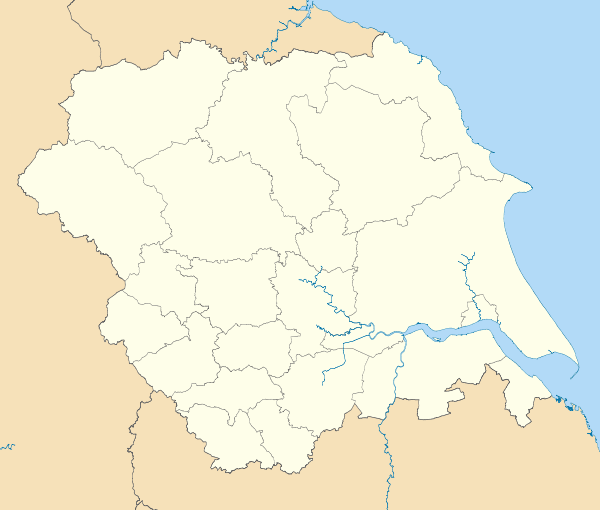
 Bradford shown within West Yorkshire | ||
| Coordinates: 53°47′31″N 1°45′14″W / 53.792°N 1.754°WCoordinates: 53°47′31″N 1°45′14″W / 53.792°N 1.754°W | ||
| Sovereign state | United Kingdom | |
| Constituent country | England | |
| Region | Yorkshire and the Humber | |
| Ceremonial county | West Yorkshire | |
| Historic county | Yorkshire | |
| Admin HQ | Bradford | |
| Borough Charter | 1847 | |
| City status | 1897 | |
| City of Bradford Met. District created | 1974 | |
| Government | ||
| • Type | Metropolitan borough, City | |
| • Governing body | City of Bradford Metropolitan District Council | |
| • City of Bradford Council Leader | Susan Hinchcliffe (Lab) | |
| • Lord Mayor | Cllr Geoff Reid (Lib Dem) | |
| • Deputy Lord Mayor | Cllr Alun Griffiths (Lib Dem) | |
| • Chief Executive | Kersten England | |
| Area | ||
| • Total | 143 sq mi (370 km2) | |
| Population (mid-2014 est.) | ||
| • Total | 528,155 (Ranked 5th) | |
| • Density | 3,341/sq mi (1,290/km2) | |
| • Ethnicity (2011 census)[3] |
67.44% White British 26.83% Asian or Asian British 1.77% Black or Black British 2.48% Mixed Race 1.48% Chinese and other | |
| Time zone | Greenwich Mean Time (UTC+0) | |
| Postcode | BD | |
| Area code(s) |
01274 (urban core/wider city) 01535 (Keighley) 01943 (Ilkley) | |
| ISO 3166-2 | GB-BFD | |
| ONS code |
00CX (ONS) E08000032 (GSS) | |
| NUTS 3 | UKE41 | |
| OS grid reference | SE164331 | |
| Euro. Parlt. Const. | Yorkshire & the Humber | |
| Website | www.bradford.gov.uk | |
The City of Bradford (![]() i/ˈbrædfərd/) is a local government district of West Yorkshire, England, with the status of a city and metropolitan borough. It is named after its largest settlement, Bradford, but covers a far larger area which includes the towns of Keighley, Shipley, Bingley, Ilkley, Haworth, Silsden and Denholme. Bradford has a population of 528,155,[4] making it the fourth-most populous metropolitan district and the sixth-most populous local authority district in England. It forms part of the West Yorkshire Urban Area conurbation which in 2001 had a population of 1.5 million[5] and the city is part of the Leeds-Bradford Larger Urban Zone (LUZ), which, with a population of 2,393,300, is the third largest in the United Kingdom after London and Manchester.[6]
i/ˈbrædfərd/) is a local government district of West Yorkshire, England, with the status of a city and metropolitan borough. It is named after its largest settlement, Bradford, but covers a far larger area which includes the towns of Keighley, Shipley, Bingley, Ilkley, Haworth, Silsden and Denholme. Bradford has a population of 528,155,[4] making it the fourth-most populous metropolitan district and the sixth-most populous local authority district in England. It forms part of the West Yorkshire Urban Area conurbation which in 2001 had a population of 1.5 million[5] and the city is part of the Leeds-Bradford Larger Urban Zone (LUZ), which, with a population of 2,393,300, is the third largest in the United Kingdom after London and Manchester.[6]
The city is situated on the edge of the Pennines, and is bounded to the east by the City of Leeds, the south east by the Metropolitan Borough of Kirklees and the south west by the Metropolitan Borough of Calderdale. The Pendle borough of Lancashire lies to the west, whilst the Craven and Harrogate boroughs of North Yorkshire lie to the north west and north east of the city. Bradford is the 4th largest metropolitan district in the country, and the contiguous urban area to the north which includes the towns of Shipley and Bingley is heavily populated. The spa town of Ilkley lies further north, whilst the town of Keighley lies to the west. Roughly two thirds of the district is rural, with an environment varying from moorlands in the north and west, to valleys and floodplains formed by the river systems that flow throughout the district. More than half of Bradford’s land is green open space, stretching over part of the Airedale and Wharfedale Valleys, across the hills and the Pennine moorland between. The Yorkshire Dales and the Peak District are both in close proximity.[7]
The City of Bradford has architecture designated as being of special or historic importance, most of which were constructed with local stone, with 5,800 listed buildings and 59 conservation areas.[8] The model village of Saltaire has been listed as a UNESCO World Heritage Site. Central Bradford rose to prominence during the 19th century as an international centre of textile manufacture, particularly wool. The area's access to a supply of coal, iron ore and soft water facilitated the growth of Bradford's manufacturing base, which, as textile manufacture grew, led to an explosion in population and was a stimulus to civic investment. However, Bradford has faced similar challenges to the rest of the post-industrial area of northern England, including deindustrialisation, housing problems, and economic deprivation. Wool and textiles still play an important part in the city's economy, but today's fastest-growing sectors include information technology, financial services, digital industries, environmental technologies, cultural industries, tourism and retail headquarters and distribution. Bradford's reputation as a base for high technology, scientific and computer-based industries is growing, building on a long tradition of innovation, high skill levels and quality products.
Bradford has experienced significant levels of immigration throughout the 19th and 20th centuries. In the 1840s Bradford's population was significantly increased by migrants from Ireland,[9] particularly rural Mayo and Sligo, and by 1851 around 18,000 people of Irish origin resided in the town, representing around 10% of the population, the largest proportion in Yorkshire. Around the same time there was also an influx of German Jewish migrants to the town, and by 1910 around 1,500 people of German origin resided in the city.[10] In the 1950s there was large scale immigration from South Asia and to a lesser extent from Poland. Bradford has the second highest proportion in England and Wales outside London, in terms of population (behind Birmingham) and fifth in percentage (behind Slough, Leicester, Luton and Blackburn with Darwen). An estimated 101,967 people of South Asian origin reside in the city,[11] representing around 19.9 of the city's population.
History
Bradford was granted the status of a city in 1897. Bradford was incorporated as a municipal borough in 1847, covering the parishes of Bradford, Horton and Manningham. It became a county borough with the passing of the Local Government Act 1888. The county borough was granted city status by Letters Patent in 1897.
Bradford was expanded in 1882 to include Allerton, Bolton, Bowling, Heaton, Thornbury and Tyersall. In 1899 it was further expanded by adding North Bierley, Eccleshill, Idle, Thornton, Tong and Wyke. Clayton was added in 1930.

The Brontë sisters, Emily, Anne and Charlotte were born along with their brother Branwell at 74 Market Street in Thornton in Bradford before moving to the parsonage at Haworth in the heart of West Yorkshire's Brontë Country where they wrote a range of classics of English literature including "Wuthering Heights" and "Jane Eyre".
The city played an important part in the early history of the Labour Party. A mural on the back of the Priestley Centre For The Arts in Little Germany commemorates the centenary of the founding of the Independent Labour Party in Bradford in 1893.[12]
The Bradford Pals were three First World War Pals battalions of Kitchener's Army raised in the city. When the three battalions were taken over by the British Army they were officially named the 16th, 18th and 20th Battalions, The Prince of Wales's Own West Yorkshire Regiment.
On the morning of 1 July 1916, an estimated 1,394 young men from Bradford and District The Bradford Pals, the 16th and 18th Battalions of the Prince of Wales Own West Yorkshire Regiment left their trenches in Northern France to advance across No Man's Land. It was the first hour of the first day of the Battle of the Somme. Of the estimated 1,394 men who left the trenches 1,094 were either killed or injured during the ill fated attack on the village of Serre.[13]
Other Bradford Battalions involved in the Battle of the Somme were 1st/6th Territorial Battalion of The Prince of Wales's Own West Yorkshire Regiment, based at Belle Vue barracks in Manningham and the 10th Battalion of The Prince of Wales's Own West Yorkshire Regiment.[14][15] The 1st/6th Territorial Battalion of The Prince of Wales's Own West Yorkshire Regiment first saw action in 1915 at Neuve Chapelle before moving north to Yser Canal near Ypres. The 10th Battalion The Prince of Wales's Own West Yorkshire Regiment was involved in the attack on Fricourt, the 10th West Yorks suffered the highest casualty rate of any battalion on the Somme on 1 July and perhaps the highest battalion casualty list for a single day during the entire war. Nearly 60% of the battalion's casualties were deaths.
In 1919 the Diocese of Bradford was founded, the Church of Saint Peter was then elevated to cathedral status.
The current city boundaries date from 1 April 1974, when the county borough of Bradford was merged with the borough of Keighley, the urban districts of Baildon, Bingley, Denholme, Ilkley, Shipley and Silsden, along with the Queensbury parts of Queensbury and Shelf Urban District and the parishes of Addingham, and Steeton with Eastburn from Skipton Rural District. Kildwick was part of Bradford at this time, but has since been moved into the Craven District (part of North Yorkshire).
The National Media Museum (formerly the National Museum of Photography, Film and Television) was established in the city in 1983. It hosts the Bradford International Film Festival annually in March. One of the first cinema shows outside London took place on the site where the National Media Museum now stands, in a music hall known as the People’s Palace.[16]
The city is the home to two annual film festivals, the Bradford International Film Festival which since its inception in 1995 has gone from strength to strength, presenting new and classic films from around the world. The Festival includes the Shine Awards - highlighting the work of new and up and coming European directors, and the ever-popular Widescreen Weekend, which draws large format enthusiasts from around the world thanks to the National Media Museum's capacity to show all film formats including Cinerama and IMAX. The film festival makes a Lifetime Achievement Award each year, the past recipients include John Hurt, Brian Cox, Sir Tom Courtenay and Michael Palin[17][18]
The Bradford Animation Festival is the longest running animation festival in the UK, having started in 1993. Past guests include representatives from studios such as Pixar, Aardman, Weta Workshops and Sony Interactive plus animators Ray Harryhausen, Richard Williams, Bob Godfrey, Caroline Leaf, Michael Dudok de Wit and Bill Plympton.[19]
With a large influx of South Asian immigrants and the local council's pursuit of a policy of multiculturalism in the 1980s, separatism between ethnic communities became an issue.[20] In 1989, a section of the Muslim community led a campaign against Salman Rushdie's The Satanic Verses, and caught the attention of the international media by publicly burning a copy of the book.[21][22] In July 2001, ethnic tensions led to rioting. The Ouseley Report, written shortly before the riots broke out, noted that Bradford had become deeply divided by segregated schooling, with communities deeply ignorant of each other, and there was widespread fear of crime and violence which West Yorkshire Police had insufficiently tackled for fear of being branded racist.[20][23]
In response to the Ouseley Report, approximately £3 million was provided by the Home Office and the Neighbourhood Renewal Fund to regenerate the city.[24] A further £2 billion was invested in regenerating the city centre, building a banqueting hall, new housing and leisure facilities.[25]
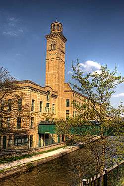
In December 2001, Saltaire was designated a World Heritage Site by UNESCO. This means that the government has a duty to protect the site. The buildings belonging to the model village are individually listed, with the highest level of protection given to the Congregational church (since 1972 known as the United Reformed Church) which is listed grade I. The village which includes Salts Mill (pictured right) has survived remarkably complete with Roberts Park on the north side of the river recently restored by Bradford Council.[26]
In October 2007, Bradford was voted the greenest city in the United Kingdom.[27] In the Sustainable Cities Index, compiled by Forum for the Future, the city was revealed to have the lowest environmental impact of any British city.[28] In spite of its undeniably large role in the Industrial Revolution, Bradford's rivers were not polluted beyond redemption, and the streams surrounding the city are now a haven of wildlife.[29] The City of Bradford has areas of green space, and recycling schemes.[30]
Bradford became the world’s first UNESCO City of Film in 2009.
The cinema connections in the city (which is also the home of the National Media Museum) are both historical and contemporary, with ongoing efforts to preserve, promote and enrich the city’s heritage of film. Bradford has been a film location since the beginning of cinema, with its indigenous film industry being traced back to the years around the First World War. By then the residents of Bradford had already witnessed important contributions to cinema development, such as the invention of the Cieroscope in Manningham in 1896.
The UNESCO City of Film designation recognises Bradford’s aim to use this history and the local popularity and accessibility of film as a major tool for regeneration, cultural development and social inclusion.[31]
Geography
The City of Bradford is situated on the edge of the Pennines, and is bounded to the east by the City of Leeds, the south east by the Metropolitan Borough of Kirklees and the south west by the Metropolitan Borough of Calderdale. The Lancashire borough of Pendle lies to the west, whilst North Yorkshire boroughs of Craven and Harrogate lie to the north west and north east respectively. Bradford district has 3636 hectares of upland heathland, including Ilkley Moor where the peat bogs rise to 402 m (1,319 ft) above sea level. Less than 5% of the Bradford district is woodland. Greenspace accounts for 73.8% of the City of Bradford's total area, domestic buildings and gardens comprise 12.1%, and the rest is made up of roads and non-domestic buildings.[32]
Three river systems serve the City of Bradford, along with 23 km of canal. The Airedale towns of Keighley, Bingley and Shipley lie on the River Aire. The River Wharfe runs through Ilkley and Burley in Wharfedale, and tributaries of the River Calder run through the district. Unusually for a major settlement, Bradford is not built on any substantial body of water. The ford from which it takes its name (Broad-Ford) was a crossing of the stream called Bradford Beck.
Parishes
Most of Bradford is unparished, there are parish and town councils for most of the outlying towns and villages in the District. From 2009, the parishes are:
- Addingham
- Baildon
- Burley
- Clayton
- Cullingworth
- Denholme
- Harden
- Haworth, Cross Roads & Stanbury
- Ilkley
- Keighley
- Menston
- Oxenhope
- Sandy Lane
- Silsden
- Steeton with Eastburn
- Trident
- Wilsden
- Wrose
Governance

Parliamentary constituencies
The residents of Bradford are represented in the British Parliament by Members of Parliament (MPs) for five separate parliamentary constituencies. Bradford East is represented by Imran Hussain (Labour), Bradford West is represented by Naz Shah (Labour), Bradford South is represented by Judith Cummins (Labour), Shipley is represented by Philip Davies (Conservative), and Keighley is represented by Kris Hopkins (Conservative).
The city played an important part in the early history of the Labour Party. A mural on the back of the Priestley Centre For The Arts (visible from Leeds Road) commemorates the centenary of the founding of the Independent Labour Party in 1893.[33]
Bradford is within the Yorkshire and the Humber European constituency, which is represented by one Conservative, one Labour, one UKIP, two Liberal Democrat and one BNP MEPs. The voting figures for Bradford in the European Parliament election in June 2009 were: Conservative 24.7%, Labour 22.6%, UKIP 14.9%, Lib Dem 13.4%, BNP 9.4%, Green 8.8%.[34]
Council
In 1974, City Of Bradford Metropolitan District Council was created to administer the newly formed metropolitan borough. The county borough of Bradford was merged with the Borough of Keighley, the Urban Districts of Baildon, Bingley, Cullingworth, Denholme, Ilkley, Shipley and Silsden, along with part of Queensbury and Shelf Urban District and part of Skipton Rural District by the Local Government Act 1972. The Council, which is based at Bradford City Hall in Centenary Square, governs the whole metropolitan district. The city was granted the right on 18 September 1907 to elect a Lord Mayor.[35]
The city is divided into 30 Electoral Wards, each ward electing three Councillors. Elections are held in May, where one third of the 90 seats (one for each ward) are contested and the successful candidate is elected for a period of four years.
| Party | Seats 2015[36] | Current Council (2015) | ||||||||||||||||||||||||||||||||||||||||||||||||||||||||||||||||||||||||||||||||||||||||||
|---|---|---|---|---|---|---|---|---|---|---|---|---|---|---|---|---|---|---|---|---|---|---|---|---|---|---|---|---|---|---|---|---|---|---|---|---|---|---|---|---|---|---|---|---|---|---|---|---|---|---|---|---|---|---|---|---|---|---|---|---|---|---|---|---|---|---|---|---|---|---|---|---|---|---|---|---|---|---|---|---|---|---|---|---|---|---|---|---|---|---|---|---|
| Labour | 46 | |||||||||||||||||||||||||||||||||||||||||||||||||||||||||||||||||||||||||||||||||||||||||||
| Conservative | 23 | |||||||||||||||||||||||||||||||||||||||||||||||||||||||||||||||||||||||||||||||||||||||||||
| Lib Dems | 9 | |||||||||||||||||||||||||||||||||||||||||||||||||||||||||||||||||||||||||||||||||||||||||||
| Independent | 8 | |||||||||||||||||||||||||||||||||||||||||||||||||||||||||||||||||||||||||||||||||||||||||||
| Greens | 3 | |||||||||||||||||||||||||||||||||||||||||||||||||||||||||||||||||||||||||||||||||||||||||||
| UKIP | 1 | |||||||||||||||||||||||||||||||||||||||||||||||||||||||||||||||||||||||||||||||||||||||||||
Electoral wards
The Metropolitan District is divided into 30 electoral wards.
| Ward name | Area (ha)/mi2 | Population | Population density (people per hectare) | Ref. |
|---|---|---|---|---|
| Baildon | 1,086 hectares (4.19 sq mi) | 12,067 | 14.33 | [37] |
| Bingley | 1,241 hectares (4.79 sq mi) | 13,675 | 11.01 | [38] |
| Bingley Rural | 3,164 hectares (12.22 sq mi) | 15,142 | 4.79 | [39] |
| Bolton and Undercliffe | 326 hectares (1.26 sq mi) | 15,445 | 47.38 | [40] |
| Bowling and Barkerend | 190 hectares (0.73 sq mi) | 17,917 | 94.3 | [41] |
| Bradford Moor | 238 hectares (0.92 sq mi) | 17,497 | 73.52 | [42] |
| City | 464 hectares (1.79 sq mi) | 18,485 | 39.80 | [43] |
| Clayton and Fairweather Green | 579 hectares (2.24 sq mi) | 15,191 | 26.24 | [44] |
| Craven | 5,008 hectares (19.34 sq mi) | 15,875 | 3.17 | [45] |
| Eccleshill | 285 hectares (1.10 sq mi) | 13,278 | 46.58 | [46] |
| Great Horton | 317 hectares (1.22 sq mi) | 16,019 | 50.47 | [47] |
| Heaton | 613 hectares (2.37 sq mi) | 16,913 | 27.59 | [48] |
| Idle and Thackley | 685 hectares (2.64 sq mi) | 14,366 | 20.97 | [49] |
| Ilkley | 1,907 hectares (7.36 sq mi) | 13,828 | 7.25 | [50] |
| Keighley Central | 508 hectares (1.96 sq mi) | 16,426 | 32.33 | [51] |
| Keighley East | 2,345 hectares (9.05 sq mi) | 15,000 | 6.4 | [52] |
| Keighley West | 939 hectares (3.63 sq mi) | 16,281 | 17.33 | [53] |
| Little Horton | 309 hectares (1.19 sq mi) | 16,431 | 53.17 | [54] |
| Manningham | 358 hectares (1.38 sq mi) | 17,522 | 48.94 | [55] |
| Queensbury | 948 hectares (3.66 sq mi) | 17,573 | 18.54 | [56] |
| Royds | 347 hectares (1.34 sq mi) | 15,266 | 43.99 | [57] |
| Shipley | 596 hectares (2.30 sq mi) | 13,822 | 23.19 | [58] |
| Thornton and Allerton | 1,376 hectares (5.31 sq mi) | 15,108 | 10.98 | [59] |
| Toller | 270 hectares (1.0 sq mi) | 18,951 | 70.24 | [60] |
| Tong | 1,348 hectares (5.20 sq mi) | 13,823 | 10.25 | [61] |
| Wharfedale | 1,573 hectares (6.07 sq mi) | 11,126 | 7.07 | [62] |
| Wibsey | 278 hectares (1.07 sq mi) | 13,447 | 48.35 | [63] |
| Windhill and Wrose | 448 hectares (1.73 sq mi) | 15,244 | 34.03 | [64] |
| Worth Valley | 5,989 hectares (23.12 sq mi) | 15,546 | 2.6 | [65] |
| Wyke | 867 hectares (3.35 sq mi) | 15,897 | 18.33 | [66] |
Coat of arms

The coat of arms of Bradford City council is based on that of the former City and County Borough Council, with additions to indicate the merger of eleven Yorkshire councils.[67] The boar's head, as in the former city council's crest, refers to the legend of the boar of Cliffe Wood. This was a ferocious wild boar that terrorised the populace and caused much damage to land and property; so much so that the Lord of the Manor offered a reward for anyone brave enough to slay the boar and bring its head to the Manor House. The mural crown is a frequent symbol of local government, but here also suggests a well head.[68] The stag is derived from the device of the Denholme Urban District Council and the arms of the former Borough of Keighley, but represents the District as a whole. The white angora goat is retained from the former arms, recalling that the wool of this animal was used in the local industries. The roses on the collars refer to the Yorkshire rose and the compartment resembles the area's hills and dales.[68]
The original Bradford Coat of Arms had the Latin words 'LABOR OMNIA VINCIT' below it, meaning Work conquers all.
Demography
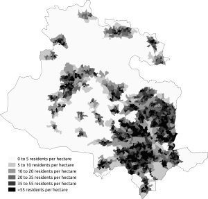
At the 2011 UK census, the City of Bradford had a population of 522,452.[70] Of the 180,246 households in Bradford, 36.5% were married couples living together, 28% were one-person households, 10.8% were lone parents and 8.4% were co-habiting couples, following a similar trend to the rest of England.[71] The population density was 1,290 inhabitants per square kilometre (3,341/sq mi) and for every 100 females, there were 92.8 males. Of those aged 16–74, 24.5% had no academic qualifications, lower than the 28.9% in all of England. 11.8% of Bradford residents were born outside the United Kingdom, higher than the England average of 9.2%.[71]
In the 2011 census, it stated that 67.44% (352,317) of the city's population was White (All White ethnic groups), 2.48% (12,979) (Mixed ethnic groups), 26.83% (140,149) (All Asian Ethnic Groups), 1.77% (9,267) (All Black ethnic groups) and 1.48% (7,740) (all other ethnic groups).[70]
The ONS Regional Trends report, published in June 2009, showed that most of the urban core[72] and 41% of the district as a whole were among the most deprived in the country, it also showed that 11% of the district as a whole were among the least deprived in the country.[73] Bradford has one of the highest unemployment rates in England,[74] with the economic inactivity rates of Black, Asian and Minority Ethnic groups standing at over 50% of the working age population.[75][76]
The crime rate in the City of Bradford is significantly higher than the national average,[77] but lower than that of similar cities such as Manchester[78] or Leeds.
Tourism

Brontë Country is an area including Western parts of the City as well as the area to the west. The City of Bradford includes the town of Haworth and the village of Thornton, the birthplace of the Brontë sisters.[79]
Keighley and Worth Valley Railway, Ilkley’s Cow and Calf Rocks, Bradford’s National Media Museum, Bradford City Park, Cartwright Hall, Saltaire village (a UNESCO World Heritage Site) and Salts Mill are key attractions that draw visitors from across the globe.[80]
The City of Bradford has also become the first UNESCO City of Film.[81]
Annual events such as the Bradford Film Festival, Bradford Festival, Bradford Mela, Bingley Music Live, Ilkley Literature Festival, Haworth’s 1940s weekend, Saltaire Festival and special Christmas events take place across the district.
The value of tourism to the district’s economy stands at more than £500 million a year, with an estimated 8.6 million day trips within the district. The impact of this is more than 13,500 jobs supported by the tourism and retail sector.[82]
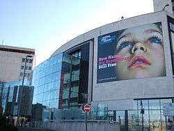
-2.jpg)


Economy
The economy of Bradford is worth around £8.3 billion, contributing around 8.4% of the region's output, and making the district the third largest after Leeds and Sheffield in Yorkshire & Humber.[83] Traditionally based on the wool and textile industries, manufacturing is still strong, accounting for around 1 in 5 jobs. The city’s service-sector economy accounts for 77% of the district's 195,000 jobs, with today's fastest-growing sectors including information technology, financial services, tourism and retail headquarters and distribution.[84] The district is home to a number of large businesses with recognised brands operating on a national and international scale such as Morrisons, Pace Plc and Hallmark Cards. Three of the UK’s biggest financial institutions are based in Bradford: Yorkshire Building Society, Bradford & Bingley Building Society and Provident Financial. It is also home to nationally outstanding cultural businesses, a strong group of new media companies, and a significant national institution in the National Media Museum. Tourism is worth over £400 million to the local economy, and employs over 10,000 people. Bradford’s exports are worth almost £700 million.[84]
The city’s working-age population has risen by 3.3% since 2000—faster than any UK city outside London, whilst the population of the city itself is growing by twice the national average. Bradford has a younger age profile than the Yorkshire & Humber regional average and the national average, with the younger age groups forming a greater proportion of the population in comparison.[85] Bradford has been named by research group OMIS as one of the top six cities in the UK equipped for future growth, and the CBI reports that business confidence is higher in Bradford than in the UK as a whole, whilst £1.5 billion of construction work is transforming Bradford in a bid to attract further investment.[84]
At the 2001 UK census, Bradford had 326,774 residents aged 16 to 74. 2.5% of these people were students with jobs, 7.6% looking after home or family, 6.1% permanently sick or disabled and 4.5% economically inactive for other reasons.[86] The City of Bradford has a lower economic activity rate than West Yorkshire, the regional average for Yorkshire and the Humber and the national average. Conversely Bradford has a higher economic inactivity rate than all these areas and also has a lower employment rate.[87]
Manufacturing is still strong in Bradford and accounts for almost 12% of all jobs, and the city’s service-sector economy accounts for 82% of the district's 192,000 jobs. The entrepreneurial spirit is more present in Bradford than generally in the UK, with start-ups accounting for 12% of the business community.[84]
Bradford’s GVA is over £6 billion.[84]
Education
Education in the city is provided for by a number of schools and colleges. State schooling is managed by Bradford local education authority. There are also a number of independent (private) and free schools, such as Bradford Grammar School, Woodhouse Grove School and Bradford Girls Grammar School. Bradford College and the University of Bradford are the main further and higher education providers.
Transport
Public transport in Bradford is co-ordinated by Metro. Most local train services are run by Northern, with longer-distance services to London King's Cross railway station served by Grand Central from Bradford Interchange and Virgin Trains East Coast from Bradford Forster Square station.
The Wharfedale Line connects direct to Ilkley, Ben Rhydding, Burley-in-Wharfedale, Menston, Guiseley, Baildon, Shipley and Frizinghall railway stations with Bradford Forster Square. The Airedale Line connects the stations at Morecambe, Lancaster, Settle, Carlisle, Skipton, Steeton and Silsden, Keighley (change for the Bronte Country and the Worth Valley Railway), Crossflatts, Bingley, Saltaire (UNESCO World Heritage Site) and Shipley, continuing to either Frizinghall and Bradford Forster Square or to Leeds to the east of the district. Both Bradford Forster Square and the districts major and busiest railway station Bradford Interchange are served by the Leeds-Bradford line with direct routes to Leeds, Selby and York. Bradford Interchange, via the Caldervale Line, also connects direct to stations at Manchester, Halifax, Rochdale, Burnley, Blackburn, Preston, Poulton-le-Fylde, Blackpool, Huddersfield, Wakefield, Doncaster and London.
There are bus stations in Bradford, Ilkley, Keighley and Shipley. The majority of services are provided by First Bradford and Keighley Bus Company.
The M606, a spur off the M62 motorway, connects the district with the national motorway network. The M606 was originally laid out to reach the centre of Bradford and beyond, but connects instead to the A6177 Bradford outer ring road, making the motorway one of the shortest in the country at less than three miles (5 km) long. Another motorway was planned in the 1970s, envisaging a link between Bradford, the Aire valley in the north of the district and the M65 at Colne, roughly mirroring the existing A650 road. It has since been upgraded to dual carriageway along much of its length, bypassing the towns of Bingley and Keighley. The A658 road passes through a tunnel underneath the main Leeds-Bradford airport runway as it heads north-east from Bradford to Knaresborough.
Leeds Bradford International Airport itself is located in Yeadon, about 10 miles (16 km) to the north-east of the city centre, and has both charter and scheduled flights to destinations within Europe plus the United States, Egypt, Pakistan, and Turkey. There are connections to the rest of the world via London Heathrow Airport, Paris-Charles de Gaulle Airport and Amsterdam Airport Schiphol.
There are also navigable waterways that run through the district. The Leeds and Liverpool Canal passes through numerous towns and villages in the borough, with the Grade I listed Five Rise Locks at Bingley generally considered to be one of the finest feats of canal engineering in the country.[88] There are also proposals to restore and re-open the Bradford Canal, which closed in 1922, as part of a wider regeneration of the city.[89]
Twin towns
The City of Bradford, and the various towns and villages that make up the Metropolitan District, have Twin Town and Sister City Friendship Agreements with several other communities.[90] Each was originally twinned with a place within the City of Bradford.
| Country | Place | Originally twinned with | Date |
|---|---|---|---|
| Belgium | Verviers | Bradford | 1970 |
| France | Coutances | Ilkley | 1969 |
| France | Eppeville | Wilsden | 1982 |
| France | Poix-du-Nord | Keighley | 1919 |
| France | Roubaix | Bradford | 1969 |
| Germany | Hamm | Shipley | 1976 |
| Germany | Mönchengladbach | Bradford | 1971 |
| Ireland | Galway | Bradford | 1987 |
| Macedonia | Skopje | Bradford | 1963 |
| Pakistan | Mirpur | Bradford | 1998 |
| Peru | Machu Picchu | Haworth | 2005 |
| United States | Haworth | Haworth | 2004 |
| United States | Myrtle Beach | Keighley | 1993 |
See also
- List of people from Bradford
- Grade I listed buildings in City of Bradford
- List of Pals battalions
- Timeline of Bradford history
Notes
- ↑ "The rise and fall of Wool City". Yorkshire Post. Retrieved 17 July 2010.
- ↑
- ↑ "Bradford (Local Authority): Key Figures for People and Society: Population and Migration". Neighbourhood Statistics. Office for National Statistics. Retrieved 18 May 2009.
- ↑ Foundation, Internet Memory. "[ARCHIVED CONTENT] UK Government Web Archive – The National Archives". Retrieved 25 July 2016.
- ↑ National Statistics (2005). "Focus on people and migration: chapter 3 The UK's major urban areas" (PDF). p. 47. Archived from the original (PDF) on 28 June 2011. Retrieved 20 October 2007.
- ↑ "Urban Audit - City Profiles: Leeds". Urban Audit. Retrieved 29 January 2009.
- ↑ "Bradford – the facts". Yorkshire Forward Government agency. Retrieved 1 November 2010.
- ↑ "Establishing Significance in Conservation Areas". English Heritage. Retrieved 30 July 2011.
- ↑ "Bradford and West Yorkshire - Around West Yorkshire - Against the odds?". BBC. Retrieved 3 September 2013.
- ↑ "Bradford and West Yorkshire - History - The Jewish connection!". BBC. 13 April 2006. Retrieved 3 September 2013.
- ↑ "Key Figures for People and Society: Population and Migration –". Neighbourhood Statistics. Office for National Statistics. Retrieved 17 July 2010.
- ↑ "ILP History: Beginnings in Bradford - ILP". Independentlabour.org.uk. 3 November 2011. Retrieved 9 December 2013.
- ↑ "Badges tribute to Pals and City fans who joined up and died together in World War One". Retrieved 25 July 2016.
- ↑ "6th Battalion, West Yorkshire Regiment (Prince of Wales's Own ) in The Great War 1914-1918". The Wartime Memories Project. Archived from the original on 2 November 2013. Retrieved 9 December 2013.
- ↑ "Prince of Wales's Own (West Yorkshire Regiment)". Warpath.orbat.com. Retrieved 9 December 2013.
- ↑ "Bradford City of Film". Bradford City of Film. Retrieved 9 December 2013.
- ↑ "Our Festivals - Film". National Media Museum. Retrieved 5 January 2014.
- ↑ http://festival.yorkshire.com/media/125153/BIFF-Lifetime-Achievement-and-Guests-Press-Release.pdf
- ↑ "About BAF - Bradford Animation Festival". National Media Museum. Retrieved 5 January 2014.
- 1 2 "Death of former head teacher Ray Honeyford sparks schooling debate". Telegraph & Argus. 11 February 2012. Retrieved 26 October 2013.
- ↑ Goodhart, David. The British Dream. Atlantic Books, London (2013): p. 157
- ↑ "What happened to the book burners?". BBC News. 13 February 2009. Retrieved 27 October 2013.
- ↑ "Blueprint for 'divided' Bradford". BBC News. 12 July 2001. Retrieved 27 October 2013.
- ↑ Community Cohesion in Crisis: New Dimensions of Diversity and Difference ed. John Flint, David Robinson. The Policy Press (2008): p. 42
- ↑ Flint & Robinson (2008): p. 43
- ↑ "Saltaire World Heritage Site". Saltairevillage.info. 1 January 2004. Retrieved 9 December 2013.
- ↑ Meneaud, Marc (20 October 2007). "City tops green list". Bradford Telegraph & Argus. Retrieved 24 October 2012.
- ↑ the sustainablecities index (PDF). UK: Forum for the Future. 2007.
- ↑ Alison Benjamin; Martin Wainwright (20 October 2007). "And the winner of the award for the greenest city in Britain is ... Bradford". The Guardian. Retrieved 24 October 2012.
- ↑ "Bradford – greenest city". hippy shopper. Retrieved 3 November 2010.
- ↑ "UK National Commission for UNESCO :: Bradford, UNESCO City of Film". Unesco.org.uk. 30 September 2013. Retrieved 9 December 2013.
- ↑ "Key Figures for Physical Environment –Area: Bradford (Local Authority)". Neighbourhood Statistics. Office for National Statistics. Retrieved 17 July 2010.
- ↑ "bradford: city for peace/site12-14". Cityforpeace.org.uk. Archived from the original on 7 October 2011. Retrieved 17 July 2010.
- ↑ Rogers, Simon (10 June 2009). "Eaxctly how well did the BNP do where you live?". Guardian: Data Blog. London. Retrieved 14 July 2009.
- ↑ The London Gazette: no. 28065. pp. 6575–6575. 1 October 1907. Retrieved 16 June 2008.
- ↑ "Local election results 2015". City of Bradford Metropolitan District Council. Retrieved 17 May 2015.
- ↑ "Population Density, 2001 (UV02) – Area: Baildon (Ward)". Neighbourhood Statistics. Office for National Statistics. Retrieved 17 July 2010.
- ↑ "Population Density, 2001 (UV02) – Area: Bingley (Ward)". Neighbourhood Statistics. Office for National Statistics. Retrieved 17 July 2010.
- ↑ "Population Density, 2001 (UV02) – Area: Bingley Rural (Ward)". Neighbourhood Statistics. Office for National Statistics. Retrieved 17 July 2010.
- ↑ "Population Density, 2001 (UV02) – Area: Bolton and Undercliffe (Ward)". Neighbourhood Statistics. Office for National Statistics. Retrieved 17 July 2010.
- ↑ "Population Density, 2001 (UV02) – Area: Bowling and Barkerend (Ward)". Neighbourhood Statistics. Office for National Statistics. Retrieved 17 July 2010.
- ↑ "Population Density, 2001 (UV02) – Area: Bradford Moor (Ward)". Neighbourhood Statistics. Office for National Statistics. Retrieved 17 July 2010.
- ↑ "Population Density, 2001 (UV02) – Area: City (Ward)". Neighbourhood Statistics. Office for National Statistics. Retrieved 17 July 2010.
- ↑ "Population Density, 2001 (UV02) – Area: Clayton and Fairweather Green (Ward)". Neighbourhood Statistics. Office for National Statistics. Retrieved 17 July 2010.
- ↑ "Population Density, 2001 (UV02) – Area: Craven (Ward)". Neighbourhood Statistics. Office for National Statistics. Retrieved 17 July 2010.
- ↑ "Population Density, 2001 (UV02) – Area: Eccleshill (Ward)". Neighbourhood Statistics. Office for National Statistics. Retrieved 17 July 2010.
- ↑ "Population Density, 2001 (UV02) – Area: Great Horton (Ward)". Neighbourhood Statistics. Office for National Statistics. Retrieved 17 July 2010.
- ↑ "Population Density, 2001 (UV02) – Area: Heaton (Ward)". Neighbourhood Statistics. Office for National Statistics. Retrieved 17 July 2010.
- ↑ "Population Density, 2001 (UV02) – Area: Idle and Thackley (Ward)". Neighbourhood Statistics. Office for National Statistics. Retrieved 17 July 2010.
- ↑ "Population Density, 2001 (UV02) – Area: Ilkley (Ward)". Neighbourhood Statistics. Office for National Statistics. Retrieved 17 July 2010.
- ↑ "Population Density, 2001 (UV02) – Area: Keighley Central(Ward)". Neighbourhood Statistics. Office for National Statistics. Retrieved 17 July 2010.
- ↑ "Population Density, 2001 (UV02) – Area: Keighley East (Ward)". Neighbourhood Statistics. Office for National Statistics. Retrieved 17 July 2010.
- ↑ "Population Density, 2001 (UV02) – Area: Keighley West (Ward)". Neighbourhood Statistics. Office for National Statistics. Retrieved 17 July 2010.
- ↑ "Population Density, 2001 (UV02) – Area: Little Horton (Ward)". Neighbourhood Statistics. Office for National Statistics. Retrieved 17 July 2010.
- ↑ "Population Density, 2001 (UV02) – Area: Manningham (Ward)". Neighbourhood Statistics. Office for National Statistics. Retrieved 17 July 2010.
- ↑ "Population Density, 2001 (UV02) – Area: Queensbury (Ward)". Neighbourhood Statistics. Office for National Statistics. Retrieved 17 July 2010.
- ↑ "Population Density, 2001 (UV02) – Area: Royds (Ward)". Neighbourhood Statistics. Office for National Statistics. Retrieved 17 July 2010.
- ↑ "Population Density, 2001 (UV02) – Area: Shipley (Ward)". Neighbourhood Statistics. Office for National Statistics. Retrieved 17 July 2010.
- ↑ "Population Density, 2001 (UV02) – Area: Thornton and Allerton (Ward)". Neighbourhood Statistics. Office for National Statistics. Retrieved 17 July 2010.
- ↑ "Population Density, 2001 (UV02) – Area: Toller (Ward)". Neighbourhood Statistics. Office for National Statistics. Retrieved 17 July 2010.
- ↑ "Population Density, 2001 (UV02) – Area: Tong (Ward)". Neighbourhood Statistics. Office for National Statistics. Retrieved 17 July 2010.
- ↑ "Population Density, 2001 (UV02) – Area: Wharfedale (Ward)". Neighbourhood Statistics. Office for National Statistics. Retrieved 17 July 2010.
- ↑ "Population Density, 2001 (UV02) – Area: Wibsey (Ward)". Neighbourhood Statistics. Neighbourhood.statistics.gov.ukOffice for National Statistics. Retrieved 17 July 2010.
- ↑ "Population Density, 2001 (UV02) – Area: Windhill and Wrose (Ward)". Neighbourhood Statistics. Office for National Statistics. Retrieved 17 July 2010.
- ↑ "Population Density, 2001 (UV02) – Area: Worth Valley (Ward)". Neighbourhood Statistics. Office for National Statistics. Retrieved 17 July 2010.
- ↑ "Population Density, 2001 (UV02) – Area: Wyke (Ward)". Neighbourhood Statistics. Office for National Statistics. Retrieved 17 July 2010.
- ↑ "Civic Heraldry Of England And Wales - Yorkshire, West Riding (Obsolete)". Civicheraldry.co.uk. Retrieved 17 July 2010.
- 1 2 "Civic Heraldry Of England And Wales - Yorkshire". Civicheraldry.co.uk. Retrieved 17 July 2010.
- ↑ "Download:output areas 2011 in Yorkshire and The Humber". NOMIS. Retrieved 1 September 2014.
- 1 2 "Bradford Metropolitan District Council - Page Not Found". Retrieved 25 July 2016.
- 1 2 "Census 2001 - Profiles - Bradford". Statistics.gov.uk. 13 February 2003. Retrieved 17 July 2010.
- ↑ "Bradford one of most deprived cities in region (From Bradford Telegraph and Argus)". Thetelegraphandargus.co.uk. 25 June 2009. Retrieved 17 July 2010.
- ↑ Archived 24 August 2009 at the Wayback Machine.
- ↑ "Accent Community Partnerships, Bradford". Showcase.hcaacademy.co.uk. Retrieved 17 July 2010.
- ↑ "Bradford District" (PDF). Archived from the original (PDF) on 31 July 2009. Retrieved 17 July 2010.
- ↑ Archived 13 August 2012 at the Wayback Machine.
- ↑ "Bradford Crime Statistics & Policing | Local Crime Rates & Stats". UpMyStreet. Retrieved 17 July 2010.
- ↑ "Manchester Crime Statistics & Policing | Local Crime Rates & Stats". UpMyStreet. Retrieved 31 August 2010.
- ↑ "Discover Bradford District". Retrieved 25 July 2016.
- ↑ "Discover Bradford District". Retrieved 25 July 2016.
- ↑ "Bradford City of Film". Retrieved 31 July 2011.
- ↑ Mead, Helen (5 July 2011). "Why tourism is on the increase in the Bradford district". Telegraph & Argus. Retrieved 14 September 2011.
- ↑ "Archived copy" (PDF). Archived from the original (PDF) on 22 February 2014. Retrieved 2013-08-08.
- 1 2 3 4 5 "Bradford: the facts and figures". Yorkshire Forward. Retrieved 17 July 2010.
- ↑ Archived 3 March 2009 at the Wayback Machine.
- ↑ "Census 2001 - Profiles - Bradford". Statistics.gov.uk. 13 February 2003. Retrieved 17 July 2010.
- ↑ http://www.bradfordinfo.com/census/pdfs/Key_Stats_Initial_Response.pdf Archived 20 February 2006 at the Wayback Machine.
- ↑ "Assessment" (PDF). Retrieved 17 July 2010.
- ↑ Archived 29 April 2009 at the Wayback Machine.
- ↑ Bradford Metropolitan District Council. "Bradford Metropolitan District Council | Twin Towns and Villages | Twin Towns and Villages Overview". Bradford.gov.uk. Archived from the original on 28 June 2009. Retrieved 17 July 2010.
References
- bradfordinfo.com has a range of statistical and other information about the District, and includes a Geographic information system accessible from mapsandstats.com
External links
| Wikisource has the text of a 1911 Encyclopædia Britannica article about Bradford. |
- City of Bradford Metropolitan District Council
- Key Statistics (PDF 1.2 MB) from the 2001 census
- Official Statistics (PDF 1.8 MB) (hint: search for 'Bradford' for pertinent figures)
- Visit Bradford website for visitor information. The site is managed by Bradford Metropolitan District Council