Circuito Exterior Mexiquense
The Circuito Exterior Mexiquense literally, "Outer Loop of the State of Mexico", also known as the Vía Mexiquense or "'Autopista mexiquense'" is a series of toll roads constructed between 2006 and 2011 by the State of Mexico government, providing an option for motorists to skirt the edge of Greater Mexico City when driving between areas in the State of Mexico to the northwest of Mexico City, northeast of Mexico City (e.g. Ecatepec) and east of Mexico City (e.g. Ciudad Nezahualcóyotl and Chalco).
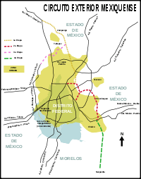
Overview of the Circuito Exterior Mexiquense.
The road was built in four phases:[1]
- Continuation of the Chamapa-Lecheria highway to Tultepec, finished in 2008.
- "Peñón Texcoco-Bordo de Xochiaca", inaugurated December 11, 2009, with a continuation at the Lago Nabor Carrillo junction with the Mexico City-Puebla Highway (Federal Highway 150).
- "Vialidad Mexiquense", from Zumpango to Tultepec, interesecting with the Mexico City–Querétaro Highway (Federal Highway 57)
The section from the Mexico City-Puebla Highway to Nepantla, southeast of the metropolitan area, remains unbuilt as of 2014.[2]
References
- ↑ "Portal de Transparencia" [Transparency Portal] (PDF) (in Spanish). Government of Mexico. 31 July 2013. Archived from the original (PDF) on April 19, 2009. Retrieved 2014-09-23.
- ↑ Alonso, Rodrigo (23 March 2011). "Circuito Exterior Mexiquense: La obra más cara de Edomex" [Mexican Outer Loop: The most expensive work by Edomex] (PDF). El Universal (in Spanish). Mexico City. Archived from the original (PDF) on 2009-04-19. Retrieved 2014-09-23.
External links
This article is issued from Wikipedia - version of the 11/25/2016. The text is available under the Creative Commons Attribution/Share Alike but additional terms may apply for the media files.