Cink
| Cink | |
|---|---|
 Cink Location in Slovenia | |
| Coordinates: 45°42′26.39″N 14°58′53.95″E / 45.7073306°N 14.9816528°ECoordinates: 45°42′26.39″N 14°58′53.95″E / 45.7073306°N 14.9816528°E | |
| Country |
|
| Traditional region | Lower Carniola |
| Statistical region | Southeast Slovenia |
| Municipality | Dolenjske Toplice |
| Elevation | 685.4 m (2,248.7 ft) |
| Population (2002) | |
| • Total | none |
Cink (pronounced [ˈtsiːŋk], also Frata;[1][2] German: Zinken[1][3]) is a remote abandoned settlement in the Municipality of Dolenjske Toplice in southern Slovenia. The area is part of the traditional region of Lower Carniola and is now included in the Southeast Slovenia Statistical Region.[4] Its territory is now part of the village of Podstenice.
History
Cink was a Gottschee German settlement. In 1924 the forest railway for the sawmill at Rog was extended toward Cink.[5] During the Second World War the Partisans established a political school for the League of Communist Youth of Yugoslavia at the site,[6][7] which was in operation for nearly a year.[8] From July to August 1942 the command of the Partisan 5th Detachment Group was stationed at Cink[9] after it was relocated from Podstenice, and a party conference was held there from 5 to 7 July[10] or 8 July[11]:219 that year. A logger's cabin or hunting cabin now stands at the site[12] and a plaque was installed on the cabin in 1953.[11]:219
Mass grave
After the Second World War, members of the Slovene Home Guard and other armed groups subordinate to the German forces were killed and buried in a mass grave east of the village known as the Double Shaft by Cink Cross Mass Grave (Slovene: Grobišče Dvojno brezno pri Cink križu). The victims are believed to have been transported to the site from the prison in Novo Mesto.[11]:220 The shafts are located at the crossroads to Cink on the road from Podstenice. The opening is 21 m long, starting below an old beech grove and continuing along a fence.[13][14][15] The bottoms of both shafts are covered by large rocks that fell there from the surface and the entryways to the shafts were dynamited.[16] The grave site is registered as cultural heritage.[17]
-
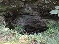
Double Shaft by Cink Cross Mass Grave
-

Double Shaft by Cink Cross Mass Grave
References
- 1 2 Leksikon občin kraljestev in dežel zastopanih v državnem zboru: Kranjsko [Gazetteer of Municipalities of the Kingdoms and Lands Represented in the National Assembly: Carniola]. 6. Vienna: C. Kr. Dvorna in Državna Tiskarna. 1906. p. 138. (Slovene)
- ↑ Heberle, Gregor (2008). Političnogeografska analiza nekdanjega kočevarskega jezikovnega otoka [A Political and Geographical Analysis of the Former Gottschee Enclave] (PDF). Ljubljana: University of Ljubljana, Faculty of Arts, Department of Geography. p. 19.
Bachelor's thesis
(Slovene) - ↑ Adresar. I. Splošna naslovna knjiga za Kranjsko [Address Book. I. General Address Book for Carniola]. Ljubljana: Mulley & Kamenšek. 1912. p. 15. (Slovene)
- ↑ "Dolenjske Toplice municipal site". Retrieved June 17, 2016. (Slovene)
- ↑ Brate, Tadej (1994). Gozdne železnice na Slovenskem [Forest Railways in Slovenia]. Ljubljana: ČZP Kmečki glas. (Slovene)
- ↑ Jarc, Janko (1967). Partizanski Rog. Maribor: Obzorja. p. 258. (Slovene)
- ↑ Šnuderl, Makso (1994). Dnevnik 1941 - 1945. 2. V partizanih [Diary 1941–1945, 2: With the Partisans]. Maribor: Obzorja. p. 59. (Slovene)
- ↑ Godina, Ferdo (20 August 1959). "Podstenice so po krivici pozabljene" [Podstenice Is Unjustly Forgotten]. Dolenjski list. 10 (33): 5. (Slovene)
- ↑ Ferenc, Mitja (1991). Kočevski Rog [Kočevje Rog]. Enciklopedija Slovenije. 5. Ljubljana: Mladinska knjiga. p. 185. (Slovene)
- ↑ "Partizanski Rog" [Rog under the Partisans]. Dolenjski list. 10 (33): 4. 20 August 1959. (Slovene)
- 1 2 3 Ferenc, Mitja; Gojko, Zupan (2012). Izgubljene kočevske vasi (K–P) [Lost Gottschee Villages (K–P)]. 2. Ljubljana: Znanstvena založba Filozofske fakultete Univerze v Ljubljani. (Slovene)
- ↑ "Pot kurirjev in vezistov: Podstenice" [Couriers and Signal Operators Trail: Podstenice]. Retrieved June 18, 2016. (Slovene)
- ↑ "112-Grobišče Dvojno brezno pri Cink križu" [Double Shaft by Cink Cross Mass Grave]. Geopedia. Retrieved June 17, 2016. (Slovene)
- ↑ Poročilo Komisije vlade Republike Slovenije za reševanje vprašanj prikritih grobišč: 2005-2008 [Report of the Commission on Concealed Mass Graves in Slovenia: 2005–2008]. Komisija za reševanje vprašanj prikritih grobišč. Ljubljana: Družina. 2008. p. 1897. (Slovene)
- ↑ Mlakar, Boris (2003). Slovensko domobranstvo, 1943-1945: ustanovitev, organizacija, idejno ozadje [Slovene Home Guard, 1943–1945: Establishment, Organization, Ideological Background]. Ljubljana: Slovenska matica. p. 519. (Slovene)
- ↑ Žohar, Saša (2008). Prostorska problematika urejanja Kočevskega Roga na primeru urejanja kraških brezen kot prikritih grobišč [Spatial Issues in Regulating Kočevje Rog Regarding Regulation of Karst Shafts as Concealed Mass Graves]. Ljubljana: University of Ljubljana, Faculty of Arts, Department of Geography. pp. 28–29.
Bachelor's thesis
(Slovene) - ↑ "Kočevski Rog - Dvojno brezno pri Cink križu ešd 8683" [Kočevje Rog - Double Shaft near Cink Cross, reference number 8683]. Slovenian Ministry of Culture register of national heritage. Retrieved June 17, 2016. (Slovene)
External links
| Settlements | Administrative centre: Dolenjske Toplice
|  |
|---|---|---|
| Landmarks |
| |