Cinder Cone and the Fantastic Lava Beds
| Cinder Cone | |
|---|---|
|
Cinder Cone is a 748-foot (213 m) high cone of loose scoria | |
| Highest point | |
| Elevation | 6,907 ft (2,105 m) NGVD 29[1] |
| Coordinates | 40°32′51″N 121°19′12″W / 40.5473847°N 121.3199729°WCoordinates: 40°32′51″N 121°19′12″W / 40.5473847°N 121.3199729°W [2] |
| Geography | |
| Location | Lassen and Shasta counties, California, U.S. |
| Parent range | Cascade Range |
| Topo map | USGS Prospect Peak |
| Geology | |
| Mountain type | Extinct Cinder cone |
| Volcanic arc | Cascade Volcanic Arc |
| Last eruption | 1680 (?) |
| Climbing | |
| Easiest route | Trail hike |

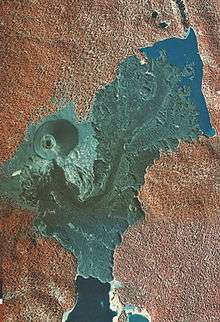
Cinder Cone is a cinder cone volcano in Lassen Volcanic National Park (located in Northern California in the United States). It is located about 10 miles (16 km) northeast of Lassen Peak and provides an excellent view of Brokeoff Mountain, Lassen Peak, and Chaos Crags.
The cone was built to a height of 750 feet (230 m) above the surrounding area and spread ash over 30 square miles (78 km2). Then, like many cinder cones, it was snuffed out when several basalt lava flows erupted from its base. These flows, called the Fantastic Lava Beds, spread northeast and southwest, and dammed creeks, first creating Snag Lake on the south and then Butte Lake to the north. Butte Lake is fed by water from Snag Lake seeping through the lava beds. Nobles Emigrant Trail goes around Snag Lake and follows the edge of the lava beds.
Its age has been controversial since the 1870s, when many people thought it was only a few decades old. Later, the cone and associated lava flows were thought to have formed about 1700 or during a 300-year- long series of eruptions ending in 1851. Recent studies by U.S. Geological Survey (USGS) scientists, working in cooperation with the National Park Service to better understand volcano hazards in the Lassen area, have firmly established that Cinder Cone was formed during two eruptions that occurred in the 1650s.[3]
Description


Cinder Cone is a 700 ft (213 m) high cone of loose scoria. Scoria forms when blobs of gas-charged lava are thrown into the air during an eruption and cool in flight, falling as dark volcanic rock containing cavities created by trapped gas bubbles. The summit of Cinder Cone has a crater with a double rim (photo), probably created by fluctuating eruptive activity late in its formation. The cone also has several associated blocky lava flows, and a related, widespread ash deposit identifiable for 8 to 10 miles (13 to 16 km) from the cone. There are actually two scoria cones at Cinder Cone—the remnants of a nearly completely buried earlier cone can be seen on the larger cone's south side. Much of the earlier cone was probably destroyed by lava flows erupting from its base. Blocks of red, cemented scoria within the Painted Dunes lava flows (photo) are pieces of this earlier cone, which were carried away by the flowing lava.[3]
During its formation, the composition of the molten rock (magma) feeding the eruption changed from basaltic andesite to andesite and then back to basaltic andesite, but with a higher titanium content. Chemically, basaltic andesites are volcanic rocks containing 53 to 57% silica (SiO2), and andesites are those containing 57 to 63% silica.[3] Though chemically distinct, the lava flows and scorias at Cinder Cone are similar in appearance. They are dark, fine-grained rocks, containing a few visible crystals of the minerals olivine, plagioclase, and quartz.
The earlier erupted group of volcanic deposits at Cinder Cone, which are relatively titanium-poor, consist of the older scoria cone, the Old Bench flow, the two Painted Dunes flows, and the lower part of the widespread ash layer. The later erupted, relatively titanium-rich group consists of the large, younger scoria cone, the upper part of the ash layer, and the two Fantastic Lava Beds flows. Flow 2 of the Fantastic Lava Beds (see geologic map) is the flow that everyone but Diller thought had been erupted in 1851.[3] The ash on the Old Bench and Painted Dunes lava flows is brightly oxidized because it fell on the lava flows when they were still hot. This oxidized ash belongs to the same compositional group as the Fantastic Lava Beds flows, the last flows erupted at Cinder Cone. All the volcanic materials at Cinder Cone therefore represent a single eruptive sequence that probably spanned no more than a few months.
An unusual characteristic of the Fantastic Lava Beds is the presence of anomalous quartz crystal xenocrysts (foreign bodies in igneous rock). Geologists think that they were picked up from wall rocks by the lava as it moved toward the surface. The lava and pyroclastics of Cinder Cone and the Fantastic Lava Beds are made of basaltic andesite to andesite.
Human history
Beginnings of a controversy

After traveling through Northern California in the spring of 1851, two gold prospectors reported seeing an erupting volcano that “threw up fire to a terrible height.”[3] They further claimed that they walked 10 miles over rocks so hot that their boots were entirely destroyed.
In the early 1870s, H. W. Harkness, a medical doctor and observant amateur scientist from San Francisco, California, visited and described the Cinder Cone area.[4] He was impressed by the apparent youthfulness of the volcanic features, and described a number of lines of evidence that he interpreted to mean that Cinder Cone was only about 25 years old.[3]
After presenting his findings at a meeting of the California Academy of Sciences, Harkness was contacted by Henry Chapman, an Academy member, who told him of hearing the gold prospectors tell their story. He was also contacted by several others who claimed to have witnessed a volcanic eruption in the Lassen area around 1851, including a O. M. Wozencraft. Harkness thought that all these tales of volcanic activity might be related to an eruption of Cinder Cone.[3]
The circumstances surrounding these reports are somewhat obscure and inconsistent. Several reports of “volcanic eruptions” in the Lassen area had appeared in Northern California newspapers in the 1850s,[3] but Harkness was probably unaware of them. In the earliest of these, published in the August 21, 1850, edition of the Daily Pacific News, a San Francisco newspaper, an unnamed observer reported seeing an erupting volcano with “burning lava still running down the sides.” In 1859, the San Francisco Times printed an article in which Wozencraft and a companion were purported to have seen, from a position somewhere west of the Lassen area, flames in the sky that they attributed to a volcanic eruption. This article was widely reprinted and popularized in other papers, but no specific date or location was given for their sighting. The Shasta Republican noted on several occasions in April 1859 (referring to Wozencraft) that the Dr.’s imagination is far more active than any volcano in our County or State. It was in Harkness’ 1875 report that the date of Wozencraft’s observation is first mentioned to be the winter of 1850–1851.[3]
Early geologic studies

The first geologist to study Cinder Cone was Joseph Diller,[5] who was among the first USGS scientists to study volcanoes. Diller made careful observations of Cinder Cone and interviewed many Native Americans and European trappers and settlers who were in the Lassen region in 1850. None of them could recall witnessing any volcanic activity in the area. Diller knew that an “emigrant road” (the Nobles Trail), used by settlers coming to California in the early 1850s, passes close to the base of Cinder Cone. He spoke with several people who had “crossed the trail” in 1853. They noted that a large, solitary willow bush (Salix scouleriana) near the summit of Cinder Cone was “as large then as now.” Today, more than a century after Diller’s interviews, this bush is still alive and little changed.[3]
Because the “Scouler willow” at the summit of Cinder Cone was already mature in 1853, Diller concluded it was extremely unlikely that an eruption could have occurred there in the winter of 1850.[3] He also noted that trees rooted in volcanic ash erupted from the cone were about 200 years old and that the oldest trees on related lava flows were about 150 years old. Diller believed he recognized two eruptive sequences, which each produced lava flows. However, he thought that only the older eruption was explosive, creating Cinder Cone and the ash deposits. In regard to the explosive eruption, he concluded that “Whatever may be the historical testimony as to the time of the eruption, the geologic evidence clearly demonstrates that it must have occurred long before the beginning of the present century”[3] (before 1800). Diller therefore speculated that the explosive eruption had occurred between about 1675 and 1700 and that the younger, quiet eruption was “certainly” sometime before 1840.
In the mid-1930s, USGS volcanologist R.H. Finch attempted to improve on Diller’s work. On the basis of other studies done at Cinder Cone, Finch thought (1) that there had been at least five separate lava-flow events, as suggested by crude, experimental magnetic measurements;[6] (2) that the youngest lava flow was extruded in 1851, accepting Harkness’ (1875) historical “evidence” and ignoring Diller’s interviews and conclusions; and (3) that there had been at least two distinct explosive eruptions of the cone.[7] Using these assumptions and tree-ring measurements, Finch proposed a complex and detailed eruptive chronology for Cinder Cone that spanned nearly 300 years.[8] From measurements of the rings of one particular tree, which showed two periods of slow growth, he thought that the two explosive eruptions occurred in 1567 and 1666. He also concluded that the five lava flows were extruded in 1567, 1666, 1720, 1785, and 1851.[3]
New geologic studies


After Finch published his work in 1937, few additional studies were done on volcano hazards in the Lassen area. However, that changed after the 1980 eruption of Mount St. Helens in Washington. As a result, the USGS began reevaluating the risks posed by other potentially active volcanoes in the Cascade Range, including those in Lassen Volcanic National Park. Since that time, USGS scientists have been working in cooperation with the National Park Service to better understand volcano hazards in the Lassen area. As part of this work, the history of Cinder Cone has been reexamined. Most of the features of Cinder Cone have changed little since Harkness first described them in the 1870s, but all of the assumptions on which Finch based his conclusions have now been shown to be incorrect.[3]
Through new field and laboratory work and by reinterpreting data from previous studies, USGS scientists have shown that the entire eruptive sequence at Cinder Cone represents a single continuous event. Because the orientation of the Earth’s magnetic field in northern California during the 1850s is well known and is different from the remnant magnetizations at Cinder Cone, the lava flows there could not have been erupted in 1850 or 1851.[3] Also, there are no discernible differences in the magnetic orientation recorded by any of the Cinder Cone lava flows, and so the flows had to be extruded during an interval of less than 50 years.
Although paleomagnetic evidence can be used to rule out the 1850s as the age of Cinder Cone, it does not provide an actual age for its eruption. By measuring levels of carbon-14 in samples of wood from trees killed by the eruption of Cinder Cone, USGS scientists obtained a radiocarbon date for the eruption of between 1630 and 1670. Such a date is also consistent with the remnant magnetization preserved in the lava flows. The series of eruptions that produced the volcanic deposits at Cinder Cone were complex and are by no means completely understood. However, the new studies done by USGS scientists refute the purported accounts of an eruption in the early 1850s and confirm Diller’s (1891, 1893) interpretation that Cinder Cone erupted in the latter half of the 17th century. They also suggest that the 1666 tree-ring date proposed by Finch (1937) for his “second” explosive eruption at Cinder Cone might actually date the entire eruptive sequence.[3][9]
See also
References

Works cited
- Finch, R.H., 1937, A tree ring calendar for dating volcanic events at Cinder Cone, Lassen Volcanic National Park, California: American Journal of Science, v. 33, p. 140-146.
- Finch, R.H., and Anderson, C.A., 1930, The quartz basalt eruptions of Cinder Cone, Lassen Volcanic National Park, California: University of California Publications in theGeological Sciences, v. 19, p. 245-273.
- Harris, Ann G.; Tuttle,Esther; Tuttle, Sherwood D. (1997). Geology of National Parks (Fifth ed.). Iowa: Kendall/Hunt Publishing. ISBN 0-7872-5353-7.
- Harkness, H.W., 1875, A recent volcano in Plumas County: California Academy of Sciences Proceedings, v. 5, p. 408-412.
| Wikimedia Commons has media related to Cinder Cone (Lassen). |
Notes
- ↑ "Cinder Cone, California". Peakbagger.com. Retrieved 2009-09-03.
- ↑ "Cinder Cone". Geographic Names Information System. United States Geological Survey. Retrieved 2009-09-03.
- 1 2 3 4 5 6 7 8 9 10 11 12 13 14 15 16
 This article incorporates public domain material from the United States Geological Survey document: Clynne, Michael A. et al. "How Old is "Cinder Cone"?–Solving a Mystery in Lassen Volcanic Park, California". Retrieved 2010-02-26.
 - ↑ Harkness, 1875
- ↑ Diller, 1891, 1893
- ↑ Jones, 1928
- ↑ Finch and Anderson, 1930
- ↑ Finch, 1937
- ↑ Sheppard, P.R.; Ort, M.H.; Anderson, K.C.; Clynne, M.A.; May, E.M. (2009). "Multiple dendrochronological responses to the eruption of Cinder Cone, Lassen Volcanic National Park, CA". Dendrochronologia. 27: 213–221.