Cincinnati Arch
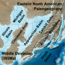
The Cincinnati Arch is a broad structural uplift between the Illinois Basin to the west, the Michigan Basin to the northwest and the Appalachian Basin and Black Warrior Basin to the east and southeast. It existed as a positive topographic area during Late Ordovician through the Devonian Period which stretched from northern Alabama northeastward to the southeastern tip of Ontario. The Nashville Dome of Tennessee and the Jessamine Dome or Lexington Dome[1] of central Kentucky make up the central portion of the arch. In the northern part, north of Cincinnati, Ohio, the Cincinnati Arch branches to form the Findlay and Kankakee arches. The Findlay plunges under Ontario and reappears as the Algonquin Arch further north.[2]
Petroleum was first discovered in the Cumberland Saddle in Cumberland County, Kentucky in 1829 and the Arch has been a major producer since that time.[2]