Cidra, Puerto Rico
| Cidra, Puerto Rico, United States | ||
|---|---|---|
| Municipality | ||
| ||
| Nickname(s): La Ciudad de la Eterna Primavera (City of Eternal Spring) | ||
| Anthem: "Del corazón de Puerto Rico nació Cidra" | ||
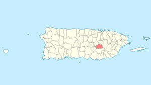 Location of Cidra in Puerto Rico | ||
| Coordinates: 18°10′33″N 66°09′41″W / 18.17583°N 66.16139°WCoordinates: 18°10′33″N 66°09′41″W / 18.17583°N 66.16139°W | ||
| Founded | 1809 | |
| Government | ||
| • Mayor | Javier Carrasquillo (PNP) | |
| • Senatorial dist. | 6 - Guayama | |
| • Representative dist. | 29 | |
| Area | ||
| • Total | 94.42 km2 (36.46 sq mi) | |
| • Land | 94 km2 (36 sq mi) | |
| • Water | .42 km2 (0.16 sq mi) | |
| Population (2010) | ||
| • Total | 43,480 | |
| • Density | 460/km2 (1,200/sq mi) | |
| Demonym(s) | Cidreños | |
| Time zone | AST (UTC-4) | |
| Zip code | 00739 | |
| FIPS code | 72-18074[1] | |
| GNIS feature ID | 1610092[2] | |
Cidra (Spanish pronunciation: [ˈsiðɾa], Cider) is a municipality of Puerto Rico located in the central region of the island, north of Cayey; south of Comerío and Aguas Buenas; east of Aibonito and Barranquitas; and west of Caguas. Cidra is spread over 12 wards and Cidra Pueblo (The downtown area and the administrative center of the city). It is part of the San Juan-Caguas-Guaynabo Metropolitan Statistical Area.
Cidra is known as La Ciudad de la Eterna Primavera (City of Eternal Spring).
History
The region of what is now Cidra belonged to the Taíno region of Cubuy, which covered a portion of the center of Puerto Rico, towards the East coast.[3] The region was led by cacique Caguax.
There are not many records that show that the region was populated after the Spanish colonization. However, it is believed that around 1795, a Catalan named Frujols built a hermitage or shrine around which a small village settled. The settlement became a ward of Cayey, until 1807 when the residents gave the power to Victoriano de Rivera to ask the Governor for permission to found an independent town. In 1809, a landowner known as Bibiana Vázquez donated the land needed for the foundation, and Governor Salvador Meléndez approved the petition. Victoriano de Rivera was appointed to lead the town, but he was quickly replaced by Wenceslao Vázquez due to illness.[4]
At the time of its foundation, Cidra had 26 houses and 11 huts. It is believed that its name is derived from the citron fruit which was widely cultivated in the region.[5][6] During the years following its foundation, a church and city hall were built. By 1922, there were already two public schools in town. Two years later, a road communicating the town with Caguas was opened. In 1868, the population of Cidra was more than 5,000 residents, which included European immigrants and slaves.
In 1902, the Legislative Assembly of Puerto Rico approved a law for the consolidation of certain municipalities. As a result, Cidra was again incorporated to the town of Cayey. However, in 1905 a new law revoked the previous one, turning Cidra into an independent municipality again.[7]
Geography
Cidra is located at the top of a hill in the eastern part of the Cordillera Central. It is bordered by the municipalities of Aguas Buenas, Caguas, Cayey, Aibonito, and Comerío. Cidra is a small municipality, covering only 36.1 square miles (94 km2).[8]
Water features
Cidra's hydrographic system consists mainly of the Lake Cidra reservoir, located in the municipality. The reservoir, which was built in 1946, provides water to several areas in the island.[9] There are also several rivers and creeks that cross the town like Arroyata, Bayamón, and Río de la Plata.
Fauna
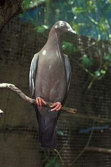
The town is known for being the nesting place of the paloma sabanera (plain pigeon). The bird, which is at risk of extinction, is currently found mostly in the town of Cidra and other nearby towns.[10]
Cityscape
Barrios
Cidra is divided into thirteen barrios or wards:[11]
- Arenas
- Bayamón
- Beatriz
- Ceiba
- Certenejas
- Cidra (Pueblo or "Downtown")
- Honduras
- Montellano
- Rabanal
- Rincón
- Río Abajo
- Salto
- Sud
- Toíta
Tourism
Although Cidra is not known as a tourist main stop, it features several places of interest to visit. The town center features historic places like Nuestra Señora del Carmen Parish and the Iberia Theater, both built during the first half of the 20th Century.
In the outskirts of the town, tourists can visit Lake Cidra and Perico's Waterfalls. Frog's Rock and Hamacas Bridge are also landmarks frequently visited by tourists.[5]
Economy
The economy of Cidra has relied mostly on agriculture, particularly coffee, tobacco, and minor fruits. Cattle ranching is also a source of economy in the town. In recent years, pharmaceutical and clothing industries have become participants of the economy of Cidra.[8][12]
Culture
A number of cultural events take place during the year, most prominently:[13]
- February — Myrna Vázquez Week
- July — Patron Saint's Day Festival (Fiestas Patronales)[14]
- November — Paloma Sabanera Festival[15]
Religion
There are a number of churches and chapels from several denominations in Cidra. The main parish, Parroquia Nuestra Señora del Carmen, was established in 1813.[16] The original structure was destroyed by earthquakes in the 1860s, but completely rebuilt by 1952.[5] Cidra's patron saint is the Virgin Mary. Its festivities are held each July.
Also in front of the town square is the First Baptist Church, which was established by American missionary Edgar Humphrey in 1903. The original wood structure was destroyed in 1928 by San Felipe Hurricane, but rebuilt in concrete, wood, and zinc.[5]
Sports
Cidra doesn't have a professional sports team. However, they have a successful amateur team, Bravos de Cidra, that participates in the Puerto Rican Amateur Baseball Federation.[17] The Bravos team has won nine championships, and as of 2014, are en route to win their third consecutive one.[18] The main baseball facility is the Jesús María Freire Stadium, where the Bravos play.
Cidra is also the birthplace of several important figures in the Puerto Rican sports scene. Some of them are former MLB players Luis Rivera and Luis López, as well as former coach of the Puerto Rico men's national basketball team Flor Meléndez. Boxer José Pedraza was also born in Cidra.
Famous Cidreños
- Vicente Carattini - Singer and Composer of Puerto Rican Christmas related songs
- Felito Félix - Singer and Composer
- Isabel Freire de Matos - was a writer, educator, journalist, and activist for Puerto Rican independence
- Antonio Torres Pérez (Pancholo) - Actor and Comedian
- Ruth Evelyn Cruz - Writer and Poet
Demographics
| Historical population | ||
|---|---|---|
| Year | Pop. | ±% |
| 1899 | 7,552 | — |
| 1910 | 10,595 | +40.3% |
| 1920 | 14,789 | +39.6% |
| 1930 | 19,662 | +33.0% |
| 1940 | 20,392 | +3.7% |
| 1950 | 20,491 | +0.5% |
| 1960 | 21,891 | +6.8% |
| 1970 | 23,892 | +9.1% |
| 1980 | 28,365 | +18.7% |
| 1990 | 35,601 | +25.5% |
| 2000 | 42,753 | +20.1% |
| 2010 | 43,480 | +1.7% |
The population of Cidra increased steadily during the 20th Century. Since 1899, the population has risen more than 200%. According to the 2010 census, the municipality currently has 43,480 inhabitants.[20]
According to the 2010 Census, 77% of the population identifies themselves as White, and 8.3% as African-American. Also, 48.9% of the population identified themselves as males, and 51.1% as females. Finally, 25% of the population is under 18 years old. The next biggest percentage of population (20.7%) is between 35 and 49 years old.[21]
Government
All municipalities in Puerto Rico are administered by a mayor, elected every four years. The current mayor of Cidra is Javier Carrasquillo, of the New Progressive Party (PNP). He succeeded Angel L. Malavé Zayas in 2012, after Malavé was accused of lewd conduct in 2011. Malavé had served as mayor since being elected at the 1988 general elections.
The city belongs to the Puerto Rico Senatorial district VI, which is represented by two Senators. In 2012, Miguel Pereira Castillo and Angel M. Rodríguez were elected as District Senators.[22]
Symbols
Flag and coat of arms
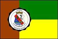
The flag of Cidra features one brown vertical stripe on the left side, with a width of about one-third the length of the flag. It also features two equal-sized horizontal stripes to the right side of the brown one. The above stripe is green, while the lower one is yellow, or golden. The golden color symbolizes the richness of the fruits and its hydrography, as well as the spiritual wealth of the region. The green symbolizes the green landscape that can be seen in Cidra throughout the year, which is also the reason why the town is called the "Town of the Eternal Spring". The brown symbolizes the Virgin, patron saint of the town, and also the Paloma sabanera that is widely seen in the area.[7]
Some versions of the flag also feature the coat of arms on the left hand side, over the intersection of the three stripes. The coat of arms was approved in the 1970s by the Municipal Assembly. It features a red band crossing the shield diagonally, from left to right. Over the red band lies a golden citrus, which is believed to be one of the reasons for the town's name, and a cornucopia of fruits, which alludes to Cidra's role as one of the major producers of fruits of the island. The upper field is either white or silver, and features two symbols: a black scapular representing the Virgin, and a black bishop hat referencing San Juan Nepomuceno, bishop and martyr. The lower field is mostly blue and features a brown pigeon flying over a mountain range, representing the location of the town in the Central Mountain Range, and a set of silver water waves. The whole seal is capped by a three-tower crown, which is usually seen in municipal seals in the island.[8]
Nicknames
Cidra is known mostly by two names. It is known as the "Town of the Eternal Spring" for its cool temperatures. It is also known as the "Town of the Plain Pigeon" because the abundance of that bird in the town.[8]
Education
There are around 15 public schools in Cidra. As with all other municipalities, education is handled by the Puerto Rico Department of Education. These are divided as follows:
Elementary school
- Ceiba Nueva - Ceiba
- Ciprián Castrodad - Río Abajo
- Luis Muñoz Rivera - Cidra
- Escuela Regino Vega Martínez - (Anterior: Escuela Nueva Santa Clara, Escuela Nueva de Arenas)
- Urbana (K-3) - Río Abajo
Junior high school
- Jesús T. Piñero (7-8) - Cidra
Mixed (elementary/junior high)
- Bilingüe - Certenejas
- Clemencia Meléndez Santos - Rabanal
- Certenejas (I & II) - Certenejas
- Juan D. Stubbe - Bayamón
- Pedro Díaz Fonseca - Beatriz
- Pedro Maria Dominicci - Rincón
High school
- Ana J. Candelas - Sud
- Luis Muñoz Iglesias - Cidra
- Vocacional Ruth Evelyn Cruz - Sud
Transportation
The main road to Cidra is Road 172, which branches out from the Puerto Rico Highway 52. Distance from the capital is roughly 40 minutes.[8] Other roads that lead to the town are #787 and #173.
See also
- List of Puerto Ricans
- History of Puerto Rico
- Did you know-Puerto Rico?
References
- ↑ "American FactFinder". United States Census Bureau. Archived from the original on 2013-09-11. Retrieved 2008-01-31.
- ↑ "Guayanilla – Populated Place". Geographic Names Information System. USGS. Retrieved 2008-05-13.
- ↑ "Gobierno Tribal del Pueblo Jatibonicu Taíno de Puerto Rico". Retrieved March 30, 2014.
- ↑ "Cidra: Fundación e historia". Enciclopedia de Puerto Rico. Retrieved March 30, 2014.
- 1 2 3 4 "Municipio de Cidra" (PDF). University of Puerto Rico at Mayagüez. Retrieved March 30, 2014.
- ↑ "Cidra: Origen e historia". Sn de aquí. Retrieved March 30, 2014.
- 1 2 "Historia de Cidra". Retrieved March 30, 2014.
- 1 2 3 4 5 "Cidra... El Pueblo de la Eterna Primavera". SalonHogar. Retrieved March 30, 2014.
- ↑ Puerto Rico Department of Natural Resources. "Lagos y Embalses de Puerto Rico". Proyecto Salón Hogar. Retrieved April 8, 2014.
- ↑ "Paloma Sabanera" (PDF). U.S. Fish & Wildlife Service. Retrieved April 8, 2014.
- ↑ "Map of Municipio de Cidra" (PDF). Retrieved 2008-05-14.
- ↑ "Cidra: Pueblo de la Eterna Primavera". Retrieved March 31, 2014.
- ↑ "Trujillo Alto: Events". Encyclopedia Puerto Rico.
- ↑ "Fiestas Patronales de Puerto Rico". Proyecto Salon Hogar.
- ↑ Ramos, Oly (December 6, 2011). "Cidra: Exitoso el Festival de la Paloma Sabanera". La Cordillera. Retrieved April 8, 2014.
- ↑ "Parroquia Nuestra Señora del Carmen: Nuestra Historia". Retrieved April 5, 2014.
- ↑ "Liga Beisbol Superior: Franquicias". Retrieved April 5, 2014.
- ↑ Sara del Valle (February 12, 2014). "Los Bravos de Cidra buscan tercera corona". El Nuevo Día. Retrieved April 5, 2014.
- ↑ Nuñez, Victoria (2009). ""Remembering Pura Belpré's Early Career at the 135th Street New York Public Library: Interracial Cooperation and Puerto Rican Settlement During the Harlem Renaisance".". Centro Journal. The City University of New York. XXI (1): 58. ISSN 1538-6279.
- ↑ "Población total por municipios, Puerto Rico: 1899-2010" (PDF). University of Puerto Rico. Retrieved March 31, 2014.
- ↑ "2010 Census Interactive Population Search: Cidra, Puerto Rico". US Census 2010.
- ↑ Elecciones Generales 2012: Escrutinio General Archived December 3, 2012, at the Wayback Machine. on CEEPUR