Chuginadak Island
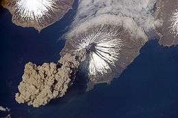 Mount Cleveland erupts in 2006. Taken from the International Space Station | |
| Geography | |
|---|---|
| Location | Aleutian Islands, Alaska, United States |
| Coordinates | 52°50′41″N 169°49′05″W / 52.84472°N 169.81806°W |
| Archipelago | Islands of Four Mountains |
| Area | 64 sq mi (170 km2) |
| Highest elevation | 5,676 ft (1,730 m) |
| Highest point | Mount Cleveland |
| Administration | |
|
United States | |
| Demographics | |
| Population | 0 |
Chuginadak Island (Aleut: Tanax̂ Angunax̂[1]) is the largest island in the Islands of Four Mountains subgroup of the Aleutian archipelago. Chuginadak is an Aleutian name published by Captain Tebenkov in an 1852 map. According to Knut Bergsland's Aleut Dictionary, the Aleutian word "chugida-lix" means "to fry, to make sizzle." The Western half of the island is called Chuginadax in Aleut, meaning 'simmering'.[1]
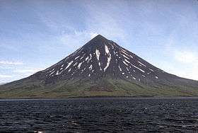
The island is approximately 14 by 6 miles (22.5 by 9.7 km) long[2] and the currently active[3] Mount Cleveland stratovolcano forms the entire western half of the land mass. A narrow strip of land separates the volcano from the rugged and lower eastern side of the island.[4]
The only major geographical place is Applegate Cove (2.5 miles across) (Chuguuĝix̂) on the Northern coast. The cove was named for Samuel Applegate, USC&GS, who commanded the schooner Nellie Juan during a survey of this area in the 1880s.[5]
References
- 1 2 Bergsland, K. (1994). Aleut Dictionary. Fairbanks: Alaska Native Language Center.
- ↑ U.S. Geological Survey Geographic Names Information System: Chuginadak Island
- ↑ Astronomy Picture of the Day: "22 June 2010"
- ↑ Alaska Volcano Observatory - Mount Cleveland
- ↑ U.S. Geological Survey Geographic Names Information System: Applegate Cove
Coordinates: 52°50′41″N 169°49′05″W / 52.84472°N 169.81806°W