Christina River
| Christina River | |
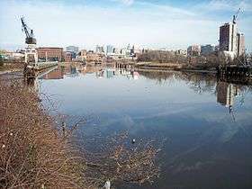 The Christina River in Wilmington in 2006 | |
| Country | United States |
|---|---|
| States | Pennsylvania, Maryland, Delaware |
| Tributaries | |
| - left | East Branch Christina River, White Clay Creek, Brandywine Creek |
| - right | West Branch Christina River |
| Cities | Newark, DE, Newport, DE, Wilmington, DE |
| Source | |
| - location | Franklin Township, Chester County, Pennsylvania |
| - elevation | 380 ft (116 m) [1] |
| - coordinates | 39°44′47″N 75°48′53″W / 39.74639°N 75.81472°W [2] |
| Mouth | Delaware River |
| - location | Wilmington, New Castle County, Delaware |
| - elevation | 0 ft (0 m) [2] |
| - coordinates | 39°42′57″N 75°30′44″W / 39.71583°N 75.51222°WCoordinates: 39°42′57″N 75°30′44″W / 39.71583°N 75.51222°W [2] |
| Length | 35 mi (56 km) approximately[3] |
| Basin | 565 sq mi (1,463 km2) [4] |
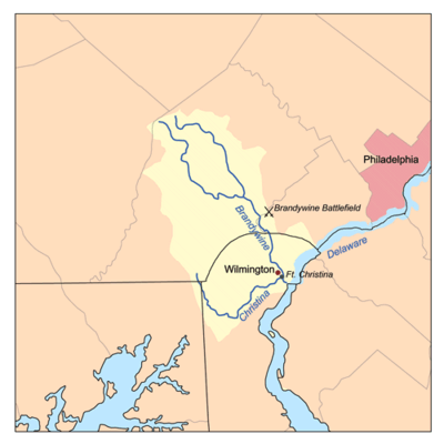 Christina River/Brandywine Creek watershed
| |
The Christina River is a tributary of the Delaware River, approximately 35 miles (56 km) long, in northern Delaware in the United States, also flowing through small areas of southeastern Pennsylvania and northeastern Maryland. Near its mouth the river flows past downtown Wilmington, Delaware, forming the city's harbor for traffic on the Delaware River. The Port of Wilmington, opened in 1923 at the river's mouth, handles international cargo and trade.[5]
The river rises in southeastern Pennsylvania, in Franklin Township in southern Chester County, and initially flows southeastwardly, passing through the northeastern extremity of Maryland in northeastern Cecil County, into New Castle County in Delaware, where it flows through western and southern areas of the city of Newark and then turns northeastwardly, passing the town of Newport and approaching Wilmington from the southwest. It receives White Clay Creek from the west near Newport, and Brandywine Creek in Wilmington, approximately 2 miles (3 km) upstream of its mouth.[6][7]

The Christina River and its tributaries drain an area of 565 square miles (1,463 km²). Brandywine Creek, despite being considered a "tributary" of the Christina, drains 58% of this area (325 mi²/842 km²). White Clay Creek and its tributary, Red Clay Creek, drain a further 28% of the basin (161 mi²/417 km²). Including Brandywine Creek, 71% of the Christina's basin is in Pennsylvania (400 mi²/1,036 km²); 28% is in Delaware (157 mi²/407 km²); and 1% is in Maryland (8 mi²/21 km²). The basin's streams supply approximately 100 million gallons (400 million liters) of water per day for more than half a million people in the three states, providing 75% of the water supply for New Castle County, Delaware, and more than 40% of the water supply for Chester County, Pennsylvania.[4]
The river was named for Queen Christina of Sweden. Fort Christina, the first permanent European settlement in Delaware, was established at the confluence of Brandywine Creek and the Christina River in 1638 as a part of the Swedish colony of New Sweden. The fort was captured by the Dutch in 1655, and by the English in 1664.[8]
Many rowing teams and clubs in Wilmington practice along the Christina River, among them the Wilmington Rowing Center, Wilmington Youth Rowing Association, Newport Rowing Club, and University of Delaware. In addition, there is a fall "head race" occurring on the river by the name of the Head of the Christina.
Just south of downtown Wilmington, the Christina provide home port to the "Kalmar Nyckel", Delaware's official Tall Ship. Co-located with the Kalmar Nyckel is the home port to the U.S. Coast Guard Auxiliary's Search and Rescue Detachment (SARDET) Wilmington.
The Christina River is also one of many Striped Bass spawning area's that empty into the Delaware River.
The Christina Riverwalk makes up a segment of the East Coast Greenway, a 3,000 mile long system of trails connecting Maine to Florida.
Variant names and spellings
According to the Geographic Names Information System, the Christina River has also been known historically as:[2]
|
|
|
See also
| Wikimedia Commons has media related to Christina River. |
References
- ↑ Google Earth. Elevation data for source coordinates.
- 1 2 3 4 Geographic Names Information System. "GNIS entry for Christina River (Feature ID #213799)". Retrieved 2007-02-18.
- ↑ "Columbia Gazetteer of North America entry for Christina River". 2000. Retrieved 2007-02-18.
- 1 2 University of Delaware: Institute for Public Administration, Water Resources Agency (1999-01-15). "Christina River Basin". Retrieved 2007-02-18.
- ↑ "Port of Wilmington website". 2006. Archived from the original on 2007-02-17. Retrieved 2007-02-18.
- ↑ DeLorme (2004). Maryland Delaware Atlas & Gazetteer. Yarmouth, Maine: DeLorme. ISBN 0-89933-279-X.
- ↑ DeLorme (2003). Pennsylvania Atlas & Gazetteer. Yarmouth, Maine: DeLorme. ISBN 0-89933-280-3.
- ↑ The Historical Society of Delaware. "Early Settlement". Retrieved 2007-02-18.
Dover (capital) | ||
| Topics |
|  |
| Society |
| |
| Cities | ||
| Towns |
| |
| Counties | ||