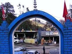
Chopta
| Chopta | |
|---|---|
| Village | |
|
Chopta, starting point for treks to Tungnath and Chandrashila. | |
| Country | India |
| State | Uttarakhand |
Chopta is a small region of meadows and evergreen forest area which is a part of kedarnath wildlife sanctuary located in Uttarakhand state, India and a base for trekking to Tungnath, third temple of Panch Kedar, which lies 3.5 kilometres (2.2 mi) away. Located at a distance of 1.5 kilometres (0.93 mi) from Tungnath is Chandrashila, a rising to over 4,000 metres (13,000 ft).
Chopta is an unspoiled natural destination lying in the lap of the Uttarakhand Himalayas and offers views of the imposing Himalayan range including Trishul, Nanda Devi and Chaukhamba. It is located at an elevation of 2,680 metres (8,790 ft) above sea level. Chopta village is surrounded by forests of pine, deodar and rhododendron and is rich in flora and fauna include rare species of birds and musk deer.
Location
This place is popularly known as 'Mini Switzerland'. It lies 29 km from Ukhimath, 254 kilometres (158 mi) from Rishikesh and approximately 450 kilometres (280 mi) from the capital Delhi. The best time to visit is from April to November. Chopta is also a popular destination during the winter months due to the snowfall that the area experiences. Tungnath temple and Chandrashila are covered with snow from December to March. Chopta can be reached from rishikesh via rudrapriyag , kund , ukhimath OR via rudrapriyag , karnpriyag , chamoli , Gopeshwar.
Activities
The Chopta - Tungnath - Chandrashila trek is a famous destinations for trekkers. The Chopta region has many treks and trails cutting through jungles and grasslands. Chandrashilla, Tunganath and Devariyatal are the best known trekking routes in the Chopta region. Because of an abundance of birds, Chopta is becoming popular among birdwatchers.
Some activities in Chopta
- Camping and trekking, yoga, survival activity
- Snow trekking, snow skiing
- Rock craft, rock climbing, rappelling
- Photography of rare himalayan species of monal bird and musk deer.
Trekking
The trek to Chopta, that can be extended to climbing the Chandrashila Peak, is a popular adventure trip among hiking lovers. Since the route lies in a protected area, the journey takes one through enchanting forests with panoramic views of the Himalayas, far from the maddening crowds. The town of Kund in Uttarakhand is the usual starting point and the entire tour can be done in 3-5 days, making it a preferred activity for city dwellers in India seeking a short getaway. The general pit stops[1] are as follows:
- Kund to Deoriatal (4-5 hours trek) - start at Kund, a quaint town situated at 1,350 m, approximately 200 km away from the spiritual town of Haridwar.
- Deoriatal to Chopta (4-5 hours trek)
- Chopta to Chandrashila Peak (4,000 m), via Tungnath Temple and back (4-5 hours trek). The distance from Tungnath Temple to Chandrashila peak is only 1 km and serves as a highlight of the trip.
The return journey from Chopta to Kund can be on foot by retracing the path or in a car. More details can be found on alienadv.
Places of interest
- Dense forest of Kedarnath Wild Life Sanctuary; where temperate and alpine trees are found in abundance. Trees like, oak, pine, burans and other himalayan species occupy major land part of Chopta, Uttarakhand region.
- Flora and fauna with high diversity
- Grass land patches (Bugyal/ Meadows)
- Chandrashilla peak 4090 m
- Tungnath temple at 3680 m
- Deoria Tal (lake) at 2350 m
- Atrimuni falls
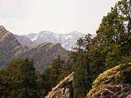
- Visibility of 41 Himalayan peaks - Meru, Sumeru, Ganesh Parwat, Chaukhamba, Bandarpunch, Nilkantha, Tirsuli, Nanda Devi etc. and Panoramic view of Himalayan mountain range.
Seasons to visit
It is a place that is yet to be fully explored and one of the best hill stations in India. Chopta is a must visit destination for nature lovers and those who are passionate for trekking. Chopta has a very cool and pleasant climate from March to May with the temperature between 10 °C and 30 °C. After that comes monsoon season that starts from July and ends in October. Chopta witnesses snowfall from November to March and the temperature is between a minimum of −15 °C and a maximum of 15 °C. It starts snowing in the month of November and increases significantly day by day. By January it is a 4- to 7-foot-thick layer of snowfall. It is fully covered with snow during winters and during the same time, some of the routes going to Chopta are blocked. An alternative route to Chopta is from Deoria Tal, which is 10–12 km trek that starts from Deorial Tal. Deoria Tal can be approached from Saari Village. It can be taken during winter season. So, trekkers must visit the place during winters if they want to see snowfields.
Summertime in Chopta does not offer clear view of Himalayas due to cloudy weather from June to August. All the peaks are covered in clouds and the view is unclear. During winters, the sky is crystal clear and all the mountains are clearly visible. It amazingly offers a 360-degree view of snow-clad mountains.
Gallery
 Snow-capped mountains view from Chopta-Tungnath Trek
_shining_over_Chandrashila_and_Tungnath.JPG) Chandra (Moon) shining over Chandrashila and Tungnath, near Chopta
Chandra (Moon) shining over Chandrashila and Tungnath, near Chopta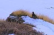 Snow partridge near Chopta
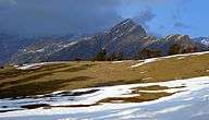 Bugyals (pastures) en route Tungnath from Chopta in evening light
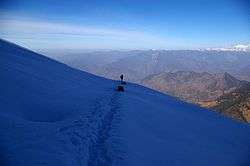
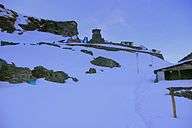 Approaching Tungnath on a winter morning
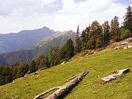 Chopta Bugyal
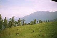 Bugyal on the way to Tungnath
See also
References
External links
| Wikimedia Commons has media related to Chopta. |
Coordinates: 29°57′N 79°05′E / 29.950°N 79.083°E