Cholatse
| Cholatse | |
|---|---|
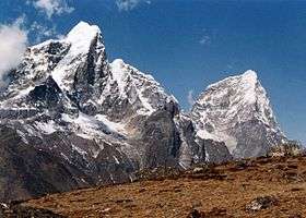 Taboche (left) and Cholatse (right)
 Cholatse and Taboche with views of Everest, Nuptse, Lhotse, Makalu, Ngozumpa glacier and Gokyo | |
| Highest point | |
| Elevation | 6,440 m (21,130 ft) [1] |
| Prominence | 750 metres (2,460 ft) |
| Coordinates | 27°55′05″N 86°46′00″E / 27.91806°N 86.76667°ECoordinates: 27°55′05″N 86°46′00″E / 27.91806°N 86.76667°E |
| Geography | |
 Cholatse Location in Nepal | |
| Location | Khumbu, Nepal |
| Parent range | Khumbu Himal |
| Climbing | |
| First ascent | 1982 by Vern Clevenger, Galen Rowell, John Roskelley and Bill O'Conner |
| Easiest route | glacier/snow/ice climb |
Cholatse (also known as Jobo Lhaptshan) is a mountain in the Khumbu region of the Nepalese Himalaya. Cholatse is connected to Taboche (6,501m) by a long ridge. The Chola glacier descends off the east face. The north and east faces of Cholatse can be seen from Dughla, on the trail to Mount Everest base camp.
There is a lake just below this pass to the east, and in Tibetan 'cho' is lake, 'la' is pass, and 'tse' is peak so Cholatse means literally "lake pass peak".[2] Cholatse was first climbed via the southwest ridge on April 22, 1982 by Vern Clevenger, Galen Rowell, John Roskelley and Bill O'Connor. The north face was successfully scaled in 1984.
Notable ascents
- 2005 North Face - first solo ascent by Ueli Steck, April 15, 2005.[3]
- 2005 Southwest Ridge - summit attained by Kevin Thaw, Conrad Anker, Kris Erickson, John Griber and Abby Watkins on May 12, 2005.[4]
References
- ↑ "Cholatse". Peakware. Retrieved 14 April 2015.
- ↑ "Cholatse". Retrieved 10 May 2013.
- ↑ MacDonald, Dougald (13 July 2005). "Solo on Cholatse and Tawoche". Climbing.com Hot Flashes. Climbing magazine. Retrieved 1 Sep 2009.
- ↑ "The Himalayan Cataract Project team Summits Cholatse!". MountEverest.net. ExplorersWeb. 12 May 2005. Retrieved 1 Sep 2009.
This article is issued from Wikipedia - version of the 4/15/2015. The text is available under the Creative Commons Attribution/Share Alike but additional terms may apply for the media files.