Chogha Mish
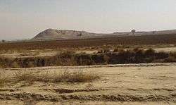
Tappeh-ye Choghā Mīsh (Persian language; ČOḠĀ MĪŠ) dating back to 6800 BC, is the site of a Chalcolithic settlement in Western Iran, located in the Khuzistan Province on the Susiana Plain. It was occupied at the beginning of 6800 BC and continuously from the Neolithic up to the Proto-Literate period. Later, the nearby Susa became culturally dominant in this area.
| Chogha Mish | |
|---|---|
 Chogha Mish Location in Iran | |
| Coordinates: 32°12′33″N 48°32′46″E / 32.20917°N 48.54611°E |
History

Chogha Mish was a regional center during the late Uruk period of Mesopotamia.
According to archaeologists,
"Prior to the fifth millennium B.C., Chogha Mish, with about 17 ha of occupation area, was the largest population center. Oriental Institute archaeological investigations at the site from 1969 to 1979 also showed increasing social and economic complexity until it was temporarily abandoned sometime in the early fifth millennium B.C., perhaps ca. 4800 BC."[1]
Nevertheless, a transitional settlement continued on a smaller scale. Around 4400 B.C., the nearby Susa was probably established, and became the largest settlement dominating the area.
The city is important today for information about the development of writing. At Chogha Mish and Susa, evidence begins with an accounting system using clay tokens, over time changing to clay tablets with marks, finally to the cuneiform writing system.
Correlations with prehistoric Mesopotamia
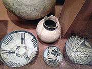
Chogha Mish provides important evidence for early connections between Susiana and Mesopotamia. The discoveries at Chogha Mish show that the Early Susiana period was contemporary with the Ubaid 1 period of southern Mesopotamia and the Samarra period of central Mesopotamia.
The Close-Line ware of Archaic Susiana 3 phase was contemporary with the Ubaid O phase, which antedates the previously known Ubaid sequence of southern Mesopotamia.[2] The painted pottery of the Samarra period in central Mesopotamia came later.[3]
Name
Chogha in the Luri language means hill and mish means Ewe.
Archaeology
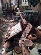
Excavations were conducted at the site between 1961 and 1978, for a total of 11 seasons by the Oriental Institute, under the direction of Pinhas Delougaz and Helene Kantor.[4][5][6]
The excavation's dig house at Qaleh Khalil was destroyed during the Iranian Revolution so many finds and records were either lost or destroyed.[7]
See also
Notes
- ↑ Abbas Alizadeh and Ali Mahfroozi, Preliminary Report on the Joint ICHTO-Oriental Institute Excavations at KS-004 and KS-108 in Lowland Susiana, Southwestern Iran. IRANIAN PREHISTORIC PROJECT 2004-2005
- ↑ Y. Calvet, “The New Deep Sounding X 36 at Tell el ʿOueili,” Sumer 44, 1985-86, pp. 67-87
- ↑ The Samarra period was contemporary with the Ubaid 1 = Eridu period in the south.
- ↑ Helene Kantor and P. Delougaz, Chogha Mish, Volume 1, Text: The First Five Seasons, 1961-1971, Oriental Institute Publication 101, 1996, ISBN 1-885923-01-5
- ↑ Helene Kantor and P. Delougaz, Chogha Mish, Volume 1, Plates: The First Five Seasons, 1961-1971, Oriental Institute Publication 101, 1996, ISBN 1-885923-01-5
- ↑ Abbas Alizadeh, Chogha Mish, Volume II. The Development of a Prehistoric Regional Center in Lowland Susiana, Southwestern Iran: (PDF full text, 483 pages) Final Report on the Last Six Seasons of Excavations, 1972-1978, Oriental Institute Publications 130, 2008, ISBN 1-885923-52-X
- ↑ Abbas Alizadeh, Excavations at the Prehistoric Mound of Chogha Bonut, Khuzestan, Iran, Seasons 1976/77, 1977/78, and 1996, Oriental Institute Publications 120, 2003, ISBN 1-885923-23-6
See also
| Dezful Choghamish - UC Oriental Institute early | ||||||||||||
|---|---|---|---|---|---|---|---|---|---|---|---|---|
|


References
- Helene J. Kantor, The Elamite Cup from Chogha Mish, Iran, vol. 15, pp. 11–14, 1977
- Abbas Alizadeh, A Protoliterate Pottery Kiln from Chogha Mish, Iran, vol. 23, pp. 39–50, 1985
External links
Coordinates: 32°13′23″N 48°33′17″E / 32.223149°N 48.554634°E