Chobe District
| Chobe | |
|---|---|
| District | |
|
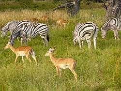
Game area in Chobe National Park | |
| Country |
|
| Capital | Kasane |
| Time zone | Central Africa Time (UTC+2) |
Chobe District is an administrative district in the northern part of Botswana, with the headquarters in Kasane. In 2001 it was merged with Ngamiland, and until 2006 it shared with Ngamiland the North-West District Council as local government. Chobe National Park is in the Chobe District. As of 2011, the total population of the district was 23,347 compared to 18,258 in 2001. The growth rate of population during the decade was 2.49. The total number of workers constituted 12,059 with 6,113 males and 5,947 females, with majority of them working in public administration.
Kasane and Chobe National Park, the second largest national park in the country, are the major tourist attractions in the district. Chobe National Park also has the largest population of elephants in Africa. The district shares the international border of the country with Namibia and Zambia in the north, Zimbabwe in the east, and also the district borders along North-West district of the country.
Geography

Kasane, Chobe National Park, Seboba Water Rapids, Pandamatenga Farms, Lesoma Memorial Monument, Kasane Hot Springs and Chobe River are the major tourist attractions in the district.[1] Most part of Botswana has tableland slopes sliding from east to west. The region has an average elevation of around 915 m (3,002 ft) above the mean sea level. The vegetation type is Savannah, with tall grasses, bushes and tress. The annual precipitation is around 65 cm (26 in), most of which is received during the summer season from November to May. Most of the rivers in the region are seasonal, with Chobe River, which are prone to flash floods, being the most prominent.[2] Chobe National Park is the second largest national park in the country and has the largest population of elephants in Africa. The district shares the international border of the country with Namibia and Zambia in the north, Zimbabwe in the east, and also the district borders along North-West district of the country.[3]
Demographics
| Historical population | ||
|---|---|---|
| Year | Pop. | ±% |
| 1981 | 7,934 | — |
| 1991 | 14,126 | +78.0% |
| 2001 | 18,258 | +29.3% |
| 2011 | 23,347 | +27.9% |
| Sources:[4] | ||
As of 2011, the total population of the district was 23,347 compared to 18,258 in 2001. The growth rate of population during the decade was 2.49. The population in the district was 1.15 per cent of the total population in the country. The sex ratio stood at 106.17 for every 100 males, compared to 106.00 in 2001. The average house hold size was 2.45 in 2011 compared to 3.60 in 2001. There were 943 craft and related workers, 573 clerks, 2,053 people working in elementary occupation 186 legislators, administrators and managers, 1,083 plant and machine operators and assemblers, 128 professionals, 1,377 service workers, shop and market sales workers, 243 skilled agricultural and related workers, and 296 technicians and associated professionals, making the total work force 6,888.[4]
Education and economy
As of 2011, there were a total of 11 schools in the district, with 1.70 per cent private schools. The total number of students in the Council schools was 3,217 while it was 64 in private schools. The total number of students enrolled in the district was 3,281: 1,587 girls and 1,694 boys. The total number of qualified teachers was 154, 98 female and 56 male. There were around 16 temporary teachers, 6 male and 22 female. There was 1 untrained teacher in the district.[5]
As of 2006, 1,260 were involved in Agriculture, 322 in Construction, 236 in Education, 76 in Electricity & Water, 095 in Finance, 070 in Foreign Mission, 236 in Health, 510 in Hotels & Restaurants, 314 in Manufacturing, 107 in Private Households, 1,743 in Public Administration, 194 in Real Estate, 185 in Transport & Communications, and 681 in Wholesale & Retail Trade. The total number of workers constituted 12,059 with 6,113 males and 5,947 females.[6]
Administration
Botswana gained independence from the British in 1966 and adapted the colonial administration framework to form its district administration. The policies were modified during 1970-74 to address some of the basic issues.[7] The district is administered by a district administration and district council which are responsible for local administration. The policies for the administration are framed by the Ministry of Local Government. The major activities of the council are Tribal Administration, Remote Area Development and Local Governance. The executive powers of the council are vested on a commissioner appointed by the central government. Technical services wing of the Department of Local Government is responsible for developing roads, infrastructure in villages like water supply, schools and recreational facilities.[8] All the staff of the local administration expect District Administration are selected via Unified Local Government Services (ULGS) and the Ministry of Local Government is responsible for their training, deployment and career development.[9] Chobe district was established during July 2008.[10]
References
- ↑ "Tourist attractions in Botswana". Government of Botswana. Retrieved 12 November 2016.
- ↑ Singh (2011). Geography. Tata McGraw-Hill Education. p. 12.53. ISBN 978-0-07-107480-3.
- ↑ "Chobe District". Chobe District Council. Retrieved 12 November 2016.
- 1 2 "Census of Botswana, 2011". Central Statistics Office of Botswana. 2015. Retrieved 12 November 2016.
- ↑ "Education details of Botswana, 2011". Central Statistics Office of Botswana. 2015. Retrieved 12 November 2016.
- ↑ "Labour Force by industry in Botswana, 20006". Central Statistics Office of Botswana. 2008. Retrieved 12 November 2016.
- ↑ Picard, Louis A. "Rural Development in Botswana: Administrative Structures and Public Policy". The Journal of Developing Areas. Louis A. Picard. 13 (3). Retrieved 12 November 2016 – via JSTOR. (subscription required (help)).
- ↑ "Regional and Local government in Botswana". Common Wealth of Nations. Retrieved 12 November 2016.
- ↑ UN-HABITAT (2002). Local Democracy and Decentralization in East and Southern Africa: Experiences from Uganda, Kenya, Botswana, Tanzania, and Ethiopia. p. 57. ISBN 9789211316667.
- ↑ Gaotlhobogwe, Monkagedi. "Botswana broken into 19 new sub-districts". MMegi Online. Retrieved 11 November 2016.
External links
Coordinates: 18°30′S 25°00′E / 18.500°S 25.000°E