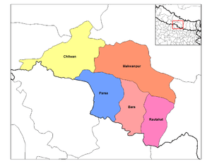
Chitwan District
| Chitwan चितवन | |
|---|---|
| District | |
|
Narayangarh city view from Maula Kalika temple Gaindakot | |
| Motto: हाम्रो चितवन, राम्रो चितवन | |
 | |
 Chitwan Location in Nepal | |
| Coordinates: 27°35′N 84°30′E / 27.583°N 84.500°ECoordinates: 27°35′N 84°30′E / 27.583°N 84.500°E | |
| Country | Nepal |
| Development Region | Central |
| Zone | Narayani Zone |
| District | Chitwan District |
| Headquarters | Bharatpur |
| HDI |
|
| HPI |
|
| Established | 14th century[2] |
| Area | |
| • Total | 2,238.39 km2 (864.25 sq mi) |
| Elevation | 415 m (1,362 ft) |
| Population (2011) | |
| • Total | 579,984[3] |
| • Ethnicities | Brahmin, Chhetri, Tharu, Newar, Gurung, Magars, Tamang, Chepang |
| • Religions | Hindu, Buddhist |
| Languages | |
| • Local | Nepali, Tharu, Newari, Tamang, Gurung, Magar, Chepang |
| • Official | Nepali |
| Time zone | Nepal Time (UTC+5:45) |
| Area code(s) | 056 |
| Website | www.ddcchitwan.gov.np |

The Chitwan District (Nepali: चितवन जिल्ला![]() Listen is one of 75 districts of Nepal, and is located in the southwestern part of Province No. 3 with Bharatpur, the fifth largest city of Nepal, as its district headquarters. It covers an area of 2,238.39 km2 (864.25 sq mi), and in 2011 had a population of 579,984 (279,087 male and 300,897 female) people.[3] Bharatpur is a commercial and service centre of central south Nepal and major destination for higher education, health care and transportation in the region.
Listen is one of 75 districts of Nepal, and is located in the southwestern part of Province No. 3 with Bharatpur, the fifth largest city of Nepal, as its district headquarters. It covers an area of 2,238.39 km2 (864.25 sq mi), and in 2011 had a population of 579,984 (279,087 male and 300,897 female) people.[3] Bharatpur is a commercial and service centre of central south Nepal and major destination for higher education, health care and transportation in the region.
History
The district takes its name from the Chitwan Valley, one of Nepal's Inner Terai valleys between the Mahabharat and Siwalik ranges, both considered foothills of the Himalayas.
Narayangadh is located on the banks of the Narayani River, and is the main town with numerous shopping zones where people come from all over the district and neighbouring districts.
Now there are about 25 Village Development Committees, each of which has nine wards or villages and one sub-Metropolitan city, Bharatpur. There are minimum of seven municipalities some of them are The Ratnanagar, Khairahani and [https://www.facebook.com/chitrawan.chitwan] Rapti Municipality ( a combination of Piple, Bhandara and Birendranagar VDCs), Jutpani Municipality and Madi municipality. Generally municipalities have nine wards or urban areas.
Chitwan is one of the few remaining undisturbed vestiges of the Terai region, which formerly extended over the foothills of Nepal.
Origin
There are several predication on the origin of the name Chitwan. Some of the most satisfactory predications on the origin of its name are:
- The name Chitwan is a composite of the Sanskrit words चित्त, transliterated "citta" meaning heart and वन, transliterated "vana" meaning jungle or forest.[4][5] Thus, the meaning of Chitwan is Heart of the Jungle.
- Chitwan was a dense forest ruled by the Tharu God/King Chitrasen Baba. He used to worship in the deep forest and ruled over his state. People believe him as the incarnation of Lord Vishnu. Still today, Tharu people worship his idol during HariBodhini Ekadashi in Chitrasari (Headquarters of Chitrasen Baba), way to Sauraha. Since the forest locally called ban (वन) was ruled by Lord Chitrasen, it was called Chitra Ban, later transliterated to Chitwan.
- Chitwan, still known as Dense Forest was a land of leopard and Bengal tiger. Leopard is locally called चित्रि according to Tharu language. Since the forest (वन) was densely populated by leopard or चित्रि, it was called the forest of leopard, namely चित्रि वन (Chitri Ban), later transliterated to Chitwan.
- Chitwan is the home land of Tharu people, who are renowned for their art and drawing. Their houses are decorated by religious drawings denoting different phases of history, culture and environment along that time. Since their homes in the forest were decorated with their drawings, locally called चित्र, the land was called चित्र वन (Chitra Ban), later transliterated to Chitwan.
Chitwan was originally a dense forest ruled by Chitrsen Baba, where different RishiMunis came to have their meditation during ancient time with numbers of wild animals like leopard and Bengal tiger.
Agriculture and industry
The people inhabiting the Chitwan District are predominantly peasant farmers cultivating mainly food and cash crops such as rice, maize, wheat, beans, lentils, mustard and vegetables. The district is the major maize producing area in Nepal, with an area under maize cultivation of 27,170 ha (104.9 sq mi) in the year 2003–04. Maize is cultivated on irrigated /seasonal irrigated land in winter and spring, and on rain fed land in summer. Due to an easy road access, maize produced can be easily distributed to other parts of the country. The poultry industry in the district constitutes a significant proportion of the country's poultry industry.[6]
Chitwan is famous in Nepal for mustard growing and production of mustard oil. This popularity of the mustard in Chitwan is attributed to the predominant soil type silt, resulting from the flooding of the Narayani River and tributaries. Chitwan is also profusely spotted with clay lands, which are very good for growing rice, wheat and vegetables such as cabbage, cauliflower, radish, potato, broccoli, cucumbers, pumpkins, and carrot. Chitwan is also famous for floriculture, mushroom cultivation and bee keeping.
At present Bharatpur's largest business area, Narayangadh, is less accessible due to the movement of the main bus terminal due to the previous king's son's anger with the politics of the citizens of the city. This bus terminal is however no longer in use following a successful people's movement in 2006. It is believed that Nepali leftist revolutionary leader Prachanda spent his childhood and youth in Chitwan. Chitwan is adapting the New Community Movement South Korean model of development.
Cuisine
Chitwan is very popular for tasty Taas (Nepali: तास) a spicy fried goat-meat lunch dish served with Bhuja or Cheura available in many restaurants. Momo, Sukuti Khaja Set and other Newa Cuisine also available. Dal bhat is the staple food of the area, meat and dairy products are also widely consumed. For centuries, traditional fermented foods and beverages have constituted about 20 per cent of the local diet. Depending on altitudinal variation, finger millet, wheat, buckwheat, barley, vegetable, potato, and soybeans are grown.
Places of interest
| Chitwan National Park | |
|---|---|
|
IUCN category II (national park) | |
|
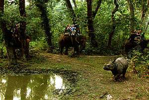
Elephant safari after an Indian rhinoceros |
 Beeshazar Lake near Chitwan National Park
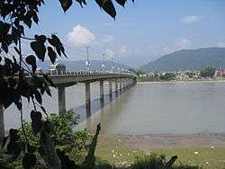 Narayani bridge in Narayangarh, Chitwan, Nepal
 Elephant polo World cup 2012 in Meghauli, Nepal
 Chitwan Mahotsav 2063 (Chitwan Mahotsav 2007 A.D.) in Narayangarh, Chitwan
Chitwan has a particularly rich flora and fauna. Nepal's first national park, the Chitwan National Park together with the adjacent Parsa Wildlife Reserve support a species diversity much higher than any other on the Indian subcontinent. Rare species include Bengal tiger, gharial, rhino, leopards, mugger crocodile, Indian rock python and several species of deer. The protected areas are guarded by a battalion of the Nepal Army and patrolled by anti-poaching units.[7]
The Rapti River flows east to south west in the south of Bharatpur and forms the northern border of the Chitwan National Park. The Narayani River flows north to south in the west of Bharatpur. It is the deepest and also one of the biggest rivers of Nepal. The Narayani Bridge over the river connects Chitwan District with Nawalparasi District of Nepal. Small islands, like Nagarban in Narayani river are popular picnic spots.
Bishazari Tal (20 Thousand) Lake is close by Chitwan National Park, about 5 km (3.1 mi) south of Bharatpur. The lake serves as an important bird watching centre and is attractive for bird lovers. It also harbours crocodiles.
Das Dhunga is a famous place in Chitwan. The people's leader Madan Bhandari was killed there in an accident.
Narayangarh is the main shopping area of Bharatpur city, and the main transit point for all the vehicles traveling via the east-west Mahendra Highway, also for the people traveling from Kathmandu, Gorkha, and Pokhara through Mugling. Recently, Narayangarh has become a retail and commercial capital of Chitwan District and Bharatpur Municipality. It is also the center for hospitality industry which includes hotels, lodges, restaurants and transportation hub for the district.
Transportation and communication
_2.jpg)
Bharatpur Airport in the central part of the city offered four domestic airlines and one government airline with seven to 11 flights daily to Kathmandu. Mahendra East West Highway connects the city to various parts of the country, and another highway connects Bharatpur with Kathmandu to the north east and with Birgunj on the border of india to the south. Bus, micro bus and other land transportation are available to go out of the city, for internal transportation taxi, rickshaw and car/jeep hiring is available. Hakim Chowk and Chaubiskothi, Shaheed Chok, Pul Chowk, Bel Chowk and Lila Chowk are major centres at intersections of major roads. Four major local FM radio stations broadcast from Bharatpur. They are Synergy FM,[8] Hamro FM, Radio Triveni,Radio Madi , Radio Chitwan,[9] Radio Kotagiri, Chitwan Online FM Kalika Music FM, Kalika FM[10] and Narayani FM. The city also has Beso Channel, "Aviyan Channel", Unique Television and Avass Television.
Land line telephone services and mobile telephone services are available to the majority of areas. There are multiple private Internet service providers.
Fort Palace and landmark buildings
- Upardanghari fort is in the old headquarters of Chitwan district and is believed to be made by Satrubhanjan Shah, son of Prince Bahadur Shah to defend newly founded Kingdom in the 17th century. It is located on the top of a hill and overlooks a very nice natural scenery.
- Kasara Durbar(Palace) is an old palace built by the Rana Regime inside Chitwan National Park. Now it is being used as an office of the national park and also hosts a museum
- Diyalo Bangala Palace (Aptari Bharatpur) was the spring season palace used by the Shah Dynasty of Nepal. This palace was built by late king Mahendra Bir Bikram Shahdev to rest in during winter season. It is located on the banks of Narayani River in Bharatpur Municipality ward no. 2.
- DAO Building Bharatpur: This old building was built in the period of shifting the headquarters from Upardangghari. Now is used as an office of the chief district officer.
- Bharatpur Covered hall: Hall in guesthouse of Bharatpur for indoor games.
Geography and climate
| Climate Zone[11] | Elevation Range | % of Area |
|---|---|---|
| Lower tropical | below 300 m (980 ft) | 58.2% |
| Upper tropical | 301 to 1,000 m (988 to 3,281 ft) | 32.6% |
| Subtropical | 1,001 to 2,000 m (3,284 to 6,562 ft) | 6.7% |
Major places
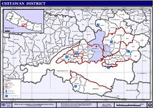
Municipalities and Village Development Committees (VDC)
Chitwan has following VDCs and municipalities.[12]
|
Medical city and hospitals
Chitwan district is also known as the medical city of Nepal. There are many top rated medical institutions in the district, although most of them are situated in and around Bharatpur Municipality. People from all over Nepal and also from North India come here for treatment. The district is especially famous for the cancer hospital at Krishnapur named after B.P. Koirala. After Kathmandu, Biratnagar and Pokhara, it is the most medically sophisticated district of Nepal. Hospitals in the district comprise:
- Bharatpur Hospital Government Hospital of Bharatpur medical college with 7 beds. It is providing all sorts of medical services to the locals, occasionally treating them.
- Chitwan Medical College Teaching Hospital is a new university hospital is in the heart of Bharatpur providing all types of medical facilities.
- Bharatpur Eye Hospital is also located in Bharatpur Municipality. With 25 bed capacity, it provides all type of services related to eye problem.
- B.P. Koirala Memorial Cancer Hospital situated at Krishnapur, Bharatpur, was established with the help of the Government of People's Republic of China in 1994, with all cancer treatment facilities this is the meager cancer treatment institution in the country. This hospital is named after B.P. Koirala, the democratic leader and the first elected prime minister of Nepal.
- CMS Teaching Hospital is the teaching hospital of Bharatpur medical college with 7 beds. It is providing medical services to the locals, occasionally treating them.
- Sairam Dental Hospital and Research Center is located at Kamalnagar Chowk, Narayangarh, providing dental Treatment for last 8 years.
- Maula Kalika Hospital is one of the oldest nursing home turned to hospital, located opposite of Bharatpur Airport, providing treatment with specialized doctors.
- Narayani Community Hospital is a relatively new hospital and is located in the heart of the city, Chaubishkothi with 150 beds.
Other important hospitals and nursing homes are Asha Hospital, Manakamana Hospital, Janasewa Hospital, Chitwan Hospital, Bharatpur Community hospital, Om Hospital, Lok Sewa Pharmacy, and Shanti hospital, Sanjivani Ayurveda & Nature Cure Hospital, Bharatpr-10
Educational institutions
Chitwan Higher Secondary School is the first school of Chitwan District. It was established in 2011 BS. It is situated in Bharatpur Municipality, Ward No. 10. Not only it having classes of Higher Secondary but it also has the Bachelor's degree in various subjects. Chitwan Higher Secondary School operates graduate courses as Pragya Chitwan Campus. It is the richest government school in Chitwan District.
- Jana Jagriti Higher Secondary School, Pithuwa – 3, Pithuwa established in 1962.
- Aroma Higher Secondary School established in 2054 BS, currently holds around 600 students in secondary level and around 1200 students in Higher Secondary Level. This schools runs Science and Management Program in XI and XII level and is one of the fast-growing institutions in Chitwan.
- Birendra Multiple Campus is the oldest campus of the city, located in the heart of the city, Bharatpur heights. This campus has played a vital role on the higher education history of Chitwan.
- Lead Academy For Science And Management Technology (LA-SMT)
- Institute of Agriculture and Animal Science, also known as the Rampur Agriculture Campus, is the agriculture institution under Tribhuvan University, and is the main institution in the fields of agriculture and veterinary science in Nepal. Occupying a huge area, this campus has been declared a university, the Agriculture and Forestry University.

- Balkumari College is located near the Narayangadh Bharatpur Height and is the first public college in the city. Balkumari College was established on 18 September 1986 and is affiliated to Tribhuvan University. The college has been awarded with Quality Assurance & Accreditation (QAA) certification by Quality Assurance & Accreditation Committee of University Grants Commission Nepal on 22 November 2009. It has already been recognized as an ISO 9001 certified institution for quality management system (QMS) in July 2008.
- Saptagandaki Multiple Campus is the largest public campus in the city, located in Dipendranagar ward no. 10, Bharatpur. The Chairperson of board of director is Ms Shobha Kattel. The Campus Chief is Mr Ram Prakash Adhikari and Assistant Campus Chiefs are Mr Maniraj Mahato, Mr Nandalal Paudel and Mr Binod Khanda Timilsena. There are about 85 teachers and about 25 supporting staff. About 3500 students are enrolled in the college.
- Jan Aadrash multiple campus Birendranagar is the public campus in Birendranagar ward no. 2.
- Saheed Smriti Multiple campus, Shantichowk is the biggest campus of eastern Chitwan. It was established in
- Birendra higher secondary school Birendranagar is the first +2 science public school.
- Bharatpur college of Medical sciences is a 700 bed teaching hospital situated in Dipendranagar, Bharatpur.
- International college is a college of higher education and runs the HSEB and TU affiliated programs in management streams. Around 800 students are enrolled currently with about 35 faculty members participating in teaching activities.
- Apex Educational Academy is a Higher Secondary School in Bharapur.
- Valmiki Shiksha Sadan Higher Secondary School provides higher secondary education.
- Shree Medical and Technical College located in Bharatpur is affilitated to the Purbanchal University and CTEVT. This college offers courses in pharmacology and nursing.
- Chitwan Health Foundation and Research Center was established in Bharatpur as the nursing School of Chitwan Hospital and Health Foundation, and is one of the pioneer educational institutions of this region catering the health related education and hospital services to the community of Chitwan region and the mid-zone territory. It was established in affiliation with CTEVTE. The college is currently running PCL Medical Laboratory Technology and PCL Nursing. Mr. J.N. Thapaliya is the chairman, Mr. Sambhu Prasad Subedi Director of CHHFRC and Mr. Deepak Subedi is the Programme Co-ordinator of PCL
- Maiya Devi Girls College is a campus specially for girls education, located in Dipendranagar, Bharatpur.
- Chitwan Medical College and Research Centre is a newly opened medical college with a teaching hospital, located in the heart of Dipendranagar, Bharatpur.
- Prerana Higher Secondary School provides education up to secondary level, and launched 10+2 program in science
- SOS Hermann Gmeiner Higher Secondary School is a science college specially for the orphans and also for the needy students only after being qualified through series of criterion.
- Sagarmatha Secondary Boarding School, Ratnanagar −11, Jamunapur
- Chitwan Science College and Orchid Science College are private +2 colleges.
- Indreni ICT college is a college for computer science and information technology, affiliated to Tribhuvan University, located at Muktinagar, Bharatpur.
- Oxford college of engineering and management, Gaindakot, offers courses like BBA, BCA, BE
- Chitwan Hotel Training Center in Bharatpur
- Apex academy in Kshetrapur, Presidency college in Dipendranagar, Shanti Academy college in Bharatpur, Xavier college in Bel chowk, Sahid Smriti Multiple Campus, New Capital College, Crystal College in Ratnanagar also hold significant number of students.
- Little flower school,narayangarh is a famous school in Chitwan district.It is declared as best school as per the result of SLC for about half decades.
- Kamal Devi English School, one of the first english medium institutions, has established itself as a pioneer school to provide quality education and produce skilled professionals for the last 3 decades.
Banks
Bharatpur has become a city of banks. There are more than 60 banks and financial institutions in Narayangarh.
- Nepal Bank Limited
- Rastriya Banijya Bank Limited
- Agriculture Development Bank Limited
- Nabil Bank Limited
- Nepal Investment Bank Limited
- Standard Chartered Bank Nepal Limited
- Himalayan Bank Limited
- Nepal SBI Bank Limited
- Nepal Bangladesh Bank Limited
- Everest Bank Limited
- Bank of Kathmandu Limited
- Nepal Credit and Commerce Bank Limited
- Lumbini Bank Limited
- Machhapuchhre Bank Limited
- Kumari Bank Limited
- Laxmi Bank Limited
- Siddhartha Bank Limited
- Global IME Bank Limited
- Citizens Bank International Limited
- Prime Commercial Bank Ltd
- Sunrise Bank Limited
- NIC Asia Nepal Limited
- Grand Bank Nepal Limited
- NMB Bank Limited
- Kist Bank Limited
- Janata Bank Nepal Limited
- Mega Bank Nepal Limited
- Commerz & Trust Bank Nepal Limited
- Civil Bank Limited
- Century Commercial Bank Limited
- Sanima Bank Limited
- Prabhu Bank Limited
Class b development banks
- Nepal Industrial Development Corporation
- Uddyam Development Bank Limited
- Malika Development Bank Limited
- Siddhartha Development Bank Limited
- United Development Bank Limited
- Manakamana Development Bank Limited
- Narayani Development Bank Limited
- Pashimanchal Development Bank Limited
- Pashupati Development Bank Limited
- Triveni Development Bank Limited
- Annapurna Development Bank Limited
- Shubhechchha Bikas Bank Limited
- Gaurishankar Development Bank Limited
- Gorkha Bikas Bank Limited
- Gandaki Bikas Bank Limited
- Western Development Bank Limited
- H. & B. Development Bank Limited**
- Arniko Development Bank Limited
- NDEP Development Bank Limited
- Clean Energy Development Bank Limited
- Miteri Development Bank Limited
- Tinau Bikas Bank Limited
- Rising Development Bank Limited
- Sewa Bikas Bank Limited
- Kankai Bikas Bank Limited
- Ace Development Bank Limited
- Sangrila Bikas Bank Limited
- Country Development Bank Limited
- Kasthamandap Development Bank Limited
- Alpine Development Bank Limited
- Kamana Bikas Bank Limited
- Biswo Bikas Bank Limited
- City Development Bank Limited
- Jyoti Development Bank Limited
- Matribhumi Bikas Bank Limited
- Metro Development Bank Limited
- Tourism Development Bank
- Mount Makalu Development Bank Limited
- Nepal Community Development Bank Limited
- Manasalu Development Bank Limited
Notable people
- Pushpa Kamal Dahal (Prachanda) : Prime Minister of Nepal 2008–2009 and chairman of UCPN[13]
- Nilkantha Upreti : Current Nepalese election commissioner
- Shesh Nath Adhikari : Elected Constituent Assembly (CA) member
- Surendra Pandey : Former Finance Minister of Nepal[14]
- Ram Bahadur Thapa (Badal) : general secretary of Communist Party of Nepal–Maoist[15]
- Shristi Shrestha : Miss Nepal 2012[16]
- Shiva Regmi : Nepalese Film director[17]
- Bodhraj Acharya : Nepalese scientists
- Kamal Bahadur Adhikari : Nepalese weightlifter
- Milan Lama – Popular Nepalese folk singer[18]
- Binita Baral – Nepalese film actress[19]
- Sudip Giri – Nepalese pop singer[20]
- Santosh Kalwar : Nepalese poet, writer, and computer researcher (first English language novelist of Chitwan)[21][22][23]
- Swopnil Sharma : Lead singer of The Shadows Nepal Band[24]
References
- ↑ Merlen, S. (ed.) (2011). An Overview of the Central Development Region. United Nations Resident & Humanitarian Coordinator's Office, Nepal
- ↑ "History". Retrieved 16 May 2010.
- 1 2 "National Population and Housing Census 2011(National Report)" (PDF). Central Bureau of Statistics. Government of Nepal. November 2012. Archived from the original (PDF) on 18 April 2013. Retrieved November 2012. Check date values in:
|access-date=(help) - ↑ Sanskrit-English Dictionary spokensanskrit.de: Sanskrit word चित्त
- ↑ Sanskrit-English Dictionary spokensanskrit.de: Sanskrit word वन
- ↑ Paudel, P. and A. Matsuoka (2008). Factors Influencing Adoption of Improved Maize Varieties in Nepal: A Case Study of Chitwan District. Australian Journal of Basic and Applied Sciences 2(4): 823–834.
- ↑ Gurung, K. K. (1983). Heart of the Jungle. The Wildlife of Chitwan, Nepal. André Deutsch, London.
- ↑ "Synergy FM 91.6 MHz".
- ↑ "Radio Chitwan 94.6 MHz".
- ↑ "Kalika FM 95.2 & 91 MHz".
- ↑ The Map of Potential Vegetation of Nepal – a forestry/agroecological/biodiversity classification system (PDF), Forest & Landscape Development and Environment Series 2-2005 and CFC-TIS Document Series No. 110, 2005, ISBN 87-7903-210-9, retrieved 22 November 2013
- ↑ "Nepal Census 2001". Nepal's village development committees. Digital Himalaya. Archived from the original on 12 October 2008. Retrieved 19 November 2008.
- ↑ Nepali PM Prachanda Sworn In. English.cri.cn. Retrieved 3 September 2011.
- ↑ "Surendra PandeyCommunist Party of Nepal (Unified-Marxist- Leninist) Election Area: Chitwan-1 (Elected)". Retrieved 8 August 2014.
- ↑ CPN-Maoist Gen Secy Thapa bereaved of father. thehimalayantimes.com. Retrieved 1 June 2014.
- ↑ About Shristi Shrestha – Miss Nepal. shristishrestha.org. Retrieved 1 June 2014.
- ↑ Regmi no more. ekantipur.com. Retrieved 10 December 2013.
- ↑ Guest on today's episode is popular folk singer. imagechannels.com. Retrieved 7 September 2014.
- ↑ Biography of Binita Baral. kathmanducraze.com. Retrieved 8 August 2014.
- ↑ Nepalese pop collection. Retrieved 11 June 2014.
- ↑ Book launch program.. Retrieved 11 June 2014.
- ↑ 'That's My Love Story' Bimochan.. Retrieved 11 June 2014.
- ↑ Facing Death.. Retrieved 6 August 2014.
- ↑ The Shadows, Nepal First Hard Rock Band.. Retrieved 6 August 2014.
External links
| Wikivoyage has a travel guide for Chitwan. |
- "Districts of Nepal". Statoids.
| Wikimedia Commons has media related to Chitwan District. |