Chinatown, Winnipeg
| Chinatown, Winnipeg | |
|---|---|
|
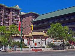
Chinese Cultural Centre in Winnipeg's Chinatown | |
| Country |
|
| Province |
|
| City | Winnipeg |
Chinatown is an area in Winnipeg, Manitoba that was formed in 1909.[1] Located on King Street between James and Higgins Avenues, it was officially recognized in 1968. Winnipeg's Chinatown is home to many shops and restaurants including Asian grocery stores and an herbal products store.[1]
History
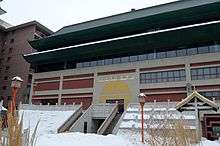
.JPG)
Winnipeg's earliest documented Chinese residents were Charley Yam, Fung Quong and an unnamed woman who came from the United States in 1877.[2] After the completion of the first phase of the CPR line in 1885, hundreds of Chinese began to settle the Prairies.[2] By 1919, Winnipeg had the fifth-largest Chinatown and Chinese community in Canada, with 900 men and a handful of women.[2]
In 1885 nearly all immigrants of Chinese descent were required by the Chinese Immigration Act to pay a head tax of $50. By 1900 that tax had risen to $100, and three years later it stood at $500. In 1923 the act was revised to exclude virtually all Chinese from entering Canada, and was colloquially known as the Chinese Exclusion Act.[3] The act was repealed in 1947. Until the act was repealed, few wives and children had been able to join husbands and fathers in Canada.[2]
Dr. Joseph Du and Philip Lee successfully lobbied Mayor Bill Norrie, the province, and federal ministers to revitalize Chinatown with the construction of the Dynasty Building, Mandarin Building, housing complex and the Chinatown gate.[2] The Dynasty Building and the Mandarin Building were completed in 1987.[1] The Dynasty building is located at King Street and Rupert Avenue and contains shops, offices,[4] and the Chinese Culture and Community Centre, which houses the only Chinese library in Manitoba.[5] The six storey Dynasty Building features Chinese influenced architecture.[1] The Mandarin Building is decorated with a replica of the Imperial Nine Dragons mural, and it is connected to the Dynasty building by a decorative street bridge.[1]
Since 1987, much of Winnipeg's Chinese population has migrated to a stretch of Pembina Highway, between the Perimeter and Bishop Grandin Boulevard. Approximately one quarter of Winnipeg's 12,700-strong Chinese-Canadian community, or 3,375 people, live in a cluster of neighbourhoods in south Fort Garry, while downtown's historic Chinatown is now home to only three per cent of the city's Chinese-Canadian population.[6]
Since 2009, a yearly street festival has been held in Chinatown. The Chinatown Street Festival features traditional dancing, singing, martial arts, food and a merchant market.[7] The festival was started as a way to commemorate the centennial of Winnipeg's Chinatown.[8] In 2011 the two-day festival expanded to include First Nations and African dance groups, and the Winnipeg Symphony Orchestra.[9]
In 2011, a new affordable housing project was announced for Chinatown. The housing project will see the construction of a 48-unit, seven-storey apartment complex to be built at Princess Street and Logan Avenue. The complex will be called the Peace Tower, and will cost an estimated $12.7 million.[10] Construction of the tower began in June 2011. In December 2011 the building at 271 - 273 Princess, known to most as Ham 'n Eggs Grill, was demolished as part of the project.[11]
In November 2012 the Shanghai Restaurant was demolished in preparation of the building of the Peace Tower. Built in 1885, the building briefly housed Winnipeg’s city hall in the 1880s.[12][13]
Demographics
As of the 2006 Census, Chinatown has 605 residents living within 0.1 square kilometres (0.039 sq mi).[14] 40.5% of the area's residents speak neither English nor French (as compared to 1% of Winnipeg as a whole), while 71.1% of residents speak some variant of Chinese (including Cantonese, Mandarin and Chinese not otherwise specified).[14] 90% are in the Chinese visible minority group.[14] 51.2% of residents reported that their place of birth was the People's Republic of China.[14]
Only 53.9% of respondents over the age of 15 stated that they have a certificate, diploma or degree, as compared to 76.9% for the whole of Winnipeg.[14] The most common mode of transport for residents is walking (38.6%), which is significantly higher than the percentage of Winnipeg residents who walk (6.2%).[14] Average income for Chinatown residents is $15,481, while the average for Winnipeg is $33,457.[14]
References
- 1 2 3 4 5 http://www.tourismwinnipeg.com/visitors/neighbourhoods/chinatown
- 1 2 3 4 5 Marshall, Alison (28 July 2012). "Chinatown steeped in 130 years of history". Winnipeg Free Press. Retrieved 12 February 2013.
- ↑ "No more Chinese!". Road to Justice. Retrieved 16 February 2013.
- ↑ "Chinatown History". WCCCC Winnipeg Chinese Cultural and Community Centre. Retrieved 9 September 2012.
- ↑ "Downtown Winnipeg Profile" (PDF). City of Winnipeg. Retrieved 9 September 2012.
- ↑ Kives, Bartley (17 January 2011). "These days, it's Chinaburbia". Winnipeg Free Press. Retrieved 12 February 2013.
- ↑ "Chinatown Festival". Downtown Winnipeg Biz. 2 August 2011. Retrieved 22 February 2013.
- ↑ Kirbyson, Geoff (12 August 2012). "Chinatown street festival dazzles crowd". Winnipeg Free Press. Retrieved 12 February 2013.
- ↑ "Chinatown Street Festival broadens its cultural celebration this weekend". Winnipeg Free Press. 5 August 2011. Retrieved 22 February 2013.
- ↑ "Chinatown to get affordable housing". Winnipeg Free Press. 9 February 2011. Retrieved 12 February 2013.
- ↑ "271 Princess - Peace Tower Housing Complex". Winnipeg Downtown Places. 13 February 2011. Retrieved 12 February 2013.
- ↑ "Shanghai Restaurant demolished to make way for seniors home". CTV News. 18 November 2012. Retrieved 16 February 2013.
- ↑ "Historical Chinatown building faces bleak future". CBC News. 3 December 2010. Retrieved 16 February 2013.
- 1 2 3 4 5 6 7 "2006 Census Data China Town" (PDF). 2006 Census Data. City of Winnipeg. Retrieved 11 October 2012.
Coordinates: 49°54′14″N 97°08′24″W / 49.904°N 97.140°W