Chimborazo Province
| Chimborazo | |||
|---|---|---|---|
| Province | |||
| Province of Chimborazo | |||
|
| |||
| |||
.svg.png) Chimborazo Province in Ecuador | |||
 Cantons of Chimborazo Province | |||
| Country | Ecuador | ||
| Legal establishment | June 25, 1826 | ||
| Capital | Riobamba | ||
| Cantons |
List of cantons
| ||
| Government | |||
| • Provincial Prefect | Mariano Curicama (Pachakutik) | ||
| Area | |||
| • Total | 6,499.72 km2 (2,509.56 sq mi) | ||
| Population (2010 census) | |||
| • Total | 458,581 | ||
| • Density | 71/km2 (180/sq mi) | ||
| Time zone | ECT (UTC-5) | ||
| Vehicle registration | B | ||
| Website |
www | ||
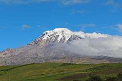
Chimborazo (Spanish pronunciation: [tʃimboˈɾaso]) is a province in the central Ecuadorian Andes. It is a home to a section of Sangay National Park. The capital is Riobamba. The province contains Chimborazo (6,267 m), Ecuador's highest mountain.
Cantons
The province is divided into 10 cantons. The following table lists each with its population at the time of the 2001 census, its area in square kilometres (km²), and the name of the canton seat or capital.[1]
| Canton | Pop. (2001) | Area (km²) | Seat/Capital |
|---|---|---|---|
| Alausí | 42,823 | 1,644 | Alausí |
| Chambo | 10,541 | 163 | Chambo |
| Chunchi | 12,474 | 273 | Chunchi |
| Colta | 44,701 | 829 | Cajabamba |
| Cumandá | 9,395 | 159 | Cumandá |
| Guamote | 35,210 | 1,216 | Guamote |
| Guano | 37,888 | 460 | Guano |
| Pallatanga | 10,800 | 377 | Pallatanga |
| Penipe | 6,485 | 370 | Penipe |
| Riobamba | 193,315 | 980 | Riobamba |
Town's in the province include Cacha.
Demographics
Ethnic groups as of the Ecuadorian census of 2010:[2]
- Mestizo 58.4%
- Indigenous 38.0%
- White 2.2%
- Afro-Ecuadorian 1.1%
- Montubio 0.3%
- Other 0.1%
See also
References
- ↑ Cantons of Ecuador. Statoids.com. Retrieved 4 November 2009.
- ↑
External links
| Wikimedia Commons has media related to Province of Chimborazo. |
- (Spanish) Gobierno de la Provincia de Chimborazo, official website
- (Spanish) Radio Mundial Riobamba
- Chimborazo area map
Coordinates: 1°40′S 78°39′W / 1.667°S 78.650°W
This article is issued from Wikipedia - version of the 11/22/2016. The text is available under the Creative Commons Attribution/Share Alike but additional terms may apply for the media files.