Chihuahua City
| City of Chihuahua | |||
|---|---|---|---|
| City | |||
|
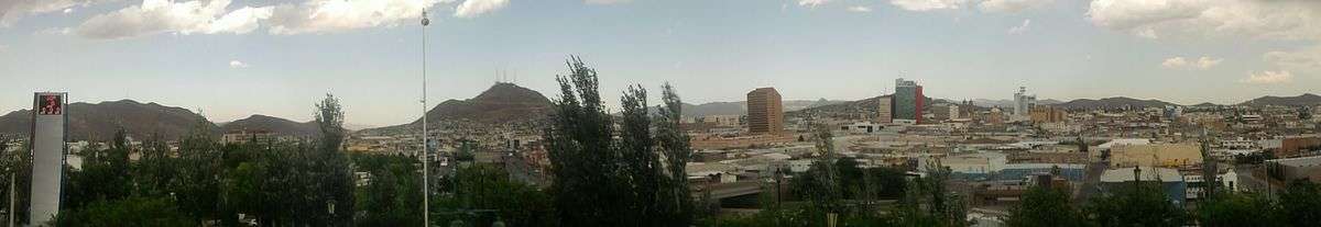
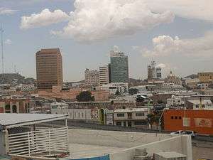
Chihuahua City in mid-May 2005 | |||
| |||
| Motto: Valentía, Lealtad, Hospitalidad (Translated to Courage, Loyalty, Hospitality) | |||
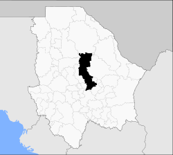 Location in the state of Chihuahua | |||
| Coordinates: 28°38′07″N 106°05′20″W / 28.63528°N 106.08889°WCoordinates: 28°38′07″N 106°05′20″W / 28.63528°N 106.08889°W | |||
| Country | Mexico | ||
| State | Chihuahua | ||
| Municipality | Chihuahua | ||
| Government | |||
| • Alcalde | Javier Garfio Pacheco (PRI) | ||
| Elevation | 1,415 m (4,635[1] ft) | ||
| Population (2013) | |||
| • Total | 925,970 | ||
| • Demonym | Chihuahuense | ||
| Time zone | MST (UTC−7) | ||
| • Summer (DST) | MDT (UTC−6) | ||
| ZIP codes | 31000 | ||
| Area code(s) | +52 614 | ||
| Climate | BSh | ||
| Website | / City of Chihuahua | ||


The city of Chihuahua (Spanish pronunciation: [tʃiˈwawa]) is the state capital of the Mexican state of Chihuahua.[2][1] It has a population of about 925,970. The predominant activity is industry, including domestic heavy, light industries, consumer goods production, and to a smaller extent maquiladoras.
History
It has been said that the name derives from the Nahuatl language, meaning "between two waters", other accepted definitions are "place of the holed-rock" "[3] or from Tarahumara, "dry and sandy place".[4] The name itself is older than the Spanish conquest of Mexico. The city was founded on October 12, 1709, by Blas Cano de los Rios and Antonio Deza y Ulloa, a Spanish explorer, as El Real de Minas de San Francisco de Cuéllar.[5][6] Don Ildefonso de Irigoyen donated the land for the city foundation.[4] The town was erected a Villa in 1718 (or 1715)[1] with the name of San Felipe el Real de Chihuahua, and the name was shortened in 1823. The location was chosen because it is the intersection of the rivers Chuviscar and Sacramento. It is also the midpoint between the Río Bravo del Norte (Rio Grande) and the then-important mining city of Hidalgo del Parral. For much of the 18th century, Chihuahua served as the de facto capital of Nueva Vizcaya because most governors preferred to reside there rather than in Durango, the capital of the province at that time.[7]
Just as in other parts of Northern Mexico, Roman Catholic missionaries were an important influence during the colonial era, and the city became a meeting point for missionaries heading to and from the 'sierra', the mountainous region in western Chihuahua State where the native Tarahumara still live.
During the War of Independence, the city saw little action. However, it was in Chihuahua where Miguel Hidalgo, considered the Father of the Country, was held prisoner in the Federal Palace of Chihuahua and executed in 1811 at the nearby Government Palace by the Spaniards.
During the Mexican-American War, Chihuahua fell to U.S. forces in 1847, after the Mexican Army was defeated at the Battle of the Sacramento, 15 miles (24 km) north of the city.

During the French invasion, President Benito Juárez made the city the seat of his government-in-exile from 1864 to 1867. During the presidency of Porfirio Díaz the city experienced explosive growth and became one of the most important cities in Mexico. The city became the seat for important banks and wealthy families.
The city was more involved during the Mexican Revolution (1910–1917), for it became at times the operations base for the División del Norte, the army led by Pancho Villa. Many sites and memories remain of the Revolutionary era; the most important of these is the Historical Museum of the Mexican Revolution at Villa's former estate house near downtown Chihuahua. La Quinta Luz was turned into a museum by his widow, Sra. María Luz Corral de Villa, and is now managed by the federal government.
During the 20th century, the city grew in population and learned to take advantage of its proximity with the U.S. border. Until the establishment of foreign manufacturing plants in the 1970s, the city was largely a trade post for cattle and agricultural products. During the 1990s the city grew dramatically economically, becoming the third wealthiest municipality (per capita) in the republic, after Benito Juárez borough of the Federal District (Mexico City), and San Pedro Garza García in Nuevo León.
In 2002, Mayor Jorge Barousse Moreno from the Institutional Revolutionary Party (PRI) died and was succeeded by Alejandro Cano Ricaud. During Cano's administration, the city experienced dramatic growth in the security sector when the Police Department was certified by the ISO and surveillance aircraft bought.
Between 2002 and 2005, the city experimented with the introduction of certain new commercial innovations, like the first large mall in the city, Plaza del Sol, and the rise of the commercial Zone of the Sun, all along the Périferico de la Juventud, one of the main thoroughfares in the city.
In 2004 Juan Blanco Zaldivar, of the National Action Party (PAN), won the election for mayor (municipal president) of the city for the term 2004–2007. Since 2005, the International Festivals of Chihuahua have been celebrated by both the state and city governments during the months of September/October with art shows, plays, stage presentations and concerts by such bands as America, Foreigner, Creedence and Los Lobos being held at venues throughout the city.
Elections for mayor for the term 2007–2010 were held at the beginning of July 2007; Carlos Borruel Baquera of the PAN defeated former mayor Alejandro Cano Ricaud (PRI) by less than one-quarter of a percentage point of almost 200,000 votes cast. The turnout of registered voters, at about 41%, was the lowest in years.
In January, 2010, Mayor Carlos Borruel submitted his resignation in order to campaign for election to the office of Governor of Chihuahua. His deputy, Lic. Alvaro Guillermo Madero Muñoz, assumed the office of mayor for the balance of his term. On July 4, 2013, Javier Garfio of the PRI won election for a 3-year term as mayor.
In December 2015, Eugenio Baeza Fares assumed office as mayor of the City of Chihuahua, after Javier Garfio Pacheco requested licence to pursue the possibility to become the candidate for the political party PRI to Governor of the State of Chihuahua.[8]
-

Execution of Miguel Hidalgo y Costilla depicted in a mural by Aarón Piña Mora in the Government Palace of Chihuahua.
-

Battle of the Sacramento, 1847
-
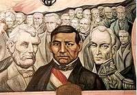
Panel of Piña mural in the Government Palace, honouring the liberators Abraham Lincoln, Benito Juárez and Simón Bolivar
-

Pancho Villa's bullet-riddled Dodge in the Historical Museum of the Mexican Revolution
Demographics
As of 2010, the city of Chihuahua had a population of 809,232.[9] up from 748,551 in 2005. A substantial population is from the U.S.
The literacy rate in the city is among the highest in the country at 98%; 35% of the population is aged 14 or below, 60% between 15 and 65 and 5% over 65.[10] The growth rate is 2.4%.[10] The life expectancy for males is 72 years and for women is 79 years.[10]
The city of Chihuahua has achieved great advances in human and social development. According to the 2005 UNCP report on human development, Chihuahua municipality's HDI value was 0.9117 – this was equal or higher than some European countries like Portugal, Czech Republic or Greece. Another report about competitiveness from the CIDE organization ranks Chihuahua as the second most competitive city in the country just behind Monterrey and ahead of Mexico city.[11] This report also ranks Chihuahua as the most Social Competitive city in the country.[11]
Cityscape
Tallest building
An equal sign (=) following a rank indicates the same height between two or more buildings. Freestanding observation and/or telecommunication towers, while not habitable buildings, are included for comparison purposes; however, they are not ranked.
| Rank | Name | Height ft (m) |
Floors | Year |
|---|---|---|---|---|
| 1 | lumina tower | 393 (120) | 32 | under construction |
| 2 | sphera tower | 347 (106) | 28 | under construction |
| 3 | cenit 3 tower | - (-) | 28 | planned |
| 4 | cenit 2 tower | - (-) | 28 | planned |
| N/A | Asta bandera el palomar | 328 (100) | 0 | — |
| 5 | cenit tower | 291 (89) | 21 | 2012 |
| 6 | legislature building | 288 (88) | 18 | 1975 |
| 7 | palacio del sol hotel | 281 (85.82) | 19 | 1980 |
| 8 | telmex tower | 203 (62) | 18 | 1981 |
| N/A | The Gate to Chihuahua | 151 (46) | 0 | 2005 |
| 9= | del real hotel | 131 (40) | 9 | 1960 |
| 10= | punto alto 2 | 131 (40) | 9 | 2002 |
| 11 | guizar building | 127 (39) | 11 | - |
| 12 | banorte building | 121 (37) | 7 | - |
| N/A= | The Angel of Liberty | 144 (35) | 4 | 2003 |
| N/A= | la puerta del sol | 144 (35) | 0 | - |
| 13 | punto alto | 111 (34) | 8 | 2000 |
| 14 | tribunales federales building | 104 (32) | 7 | 2001 |
| 15 | scotiabank plaza | 101 (31) | 8 | - |
| N/A= | the tree of life | 98 (30) | 0 | - |
| 16= | pit 3 building | 98 (30) | 10 | 2012 |
| 17= | A.CH.B building | 98 (30) | 8 | - |
| 18 | fiesta inn hotel | 89 (27.29) | 7 | 1993 |
| 19 | Westin Soberano hotel | 88 (27.10) | 6 | - |
| 20 | roma building | 86 (26.5) | 6 | - |
| 21 | corporativo roma | 80 (24.6) | 6 | - |
| N/A | Asta bandera | 75 (23) | 0 | 2013 |
| 22 | banobras building | 75 (23) | 6 | - |
| N/A | monument tower | 68 (21) | 0 | 2011 |
| N/A | mirador tower | 65 (20) | 5 | - |
Landmarks

Even though Chihuahua suffered a massive destruction of colonial buildings during the 1970s in order to widen the main streets and avenues in the downtown, it stills preserves some valuable monuments from the 19th and 20th centuries. Some of the more interesting sites in the city are listed below:
- Temple of San Francisco, commenced 1717 and completed in 1789[1]-The original burial place of Fr Miguel Hidalgo
- Federal Palace of Chihuahua, now a museum, and the jail cell of Fr Hidalgo
- Museo Casa Juarez, also called The Museum of the Republican Loyalty, is the house where President Juarez lived during his time at Chihuahua City.
- Central Park "El Palomar"-Once one of the worst slums in the city, now the largest city park.
- Mansion Creel
- Mansion Terrazas
- Mansion 'Quinta Carolina' (Former summer estate of Don Luis Terrazas; see Creel-Terrazas Family.)-Now in semi-ruined condition, in process of restoration.
- Torre Legislativa de Chihuahua (Legislative tower of Chihuahua-state legislators office building) -Fronts on the Plaza de Armas
- The Government Palace (The State House)
- City Hall
- Dancing Fountains north of the Federal Palace
- Mansion 'Quinta Gameros' (City Museum for the Decorative Arts)
- Church of Santa Rita (1731). St Rita of Cascia is the patroness of the city.
- Ave. Zarco Residential Area (Some of the most impressive pre-revolutionary residences in the city are situated along this street)
- Colonial Aqueduct-lengths still exist of this monument which was built to transport water from mountain springs to the villa.

Colonias
The City of Chihuahua is subdivided into Colonias (neighborhoods). The primary function of the colonias range in function between residential, commercial, industrial, and educational.
In recent years, gated residential zones called "fraccionamientos", along with colonias, have been erected. The fraccionamientos function in the same way as residential developments in the U.S. The growing construction industry is creating many new fraccionamientos in order to try to solve the overwhelming demand for new homes in the city, extending them at an ever-increasing rate every year.
Malls
- Fashion Mall
- Plaza Galerías
- Distrito 1
- Tres vias shopping center
- Plaza San Felipe
- La Liber
- Plaza Hollywood
- Plaza Victoria
- Plaza Vallarta
- Plaza Providencia
- Plaza Tolsa
Parks
- El Palomar
- Ciudad Deportiva
- Deportiva Sur
- Parque metropolitano el rejon
There are two country clubs in the city: San Francisco Country Club and Campestre Chihuahua
Economy
Chihuahua is the twelfth largest city in Mexico, and one of the most industrialized. Manufacturing is very important and there are nine major industrial parks and 79 maquila manufacturing plants, which employ about 45,000 people. The city serves as an alternative destination for maquiladora operators who require quick access to the border but wish to avoid both the higher costs and higher turnover rates of employment of the immediate border area. Of all interior (non-border) locations in Mexico, Chihuahua has the largest maquiladora presence in Mexico. Some of the larger companies include Ford Motor Co., Sumitomo Electrical, Honeywell, Hallmark, and LG Electronics.
The entire state of Chihuahua is also a thriving economic center. Chihuahua's annual Gross State Product (GSP) is about $6.2 billion. There are more than 350 established manufacturing and assembly plants in the state; manufacturing accounts for a third of the total GSP, while trade and other services amount to 53.5%. Chihuahua has the largest amount of forested land in all of Mexico. Forty-four percent of Chihuahua's workers are employed in commerce and services, while a little over a third of the workforce is employed in mining and industry. In mining, Chihuahua state is the leading producer in the republic of non-ferrous minerals and zinc, and is second nationwide in silver extraction. Agricultural production makes up only 6% of the total GSP, however the state is the leading producer of apples, nuts, cattle and sheep raising nationally, and second in pine and oak trees harvested.
Contemporary life
The city's most important feature is its collection of industrial zones, in which foreign companies have manufacturing facilities, called maquiladoras, which employ thousands of people. This light industry also requires professionals, both for manufacturing and for management; this training is provided by universities such as the Universidád Autónoma de Chihuahua,[12] the Instituto Tecnológico de Chihuahua and Instituto Tecnológico de Chihuahua II. A number of private universities also exist, to include the Chihuahua campus of ITESM.
The city's commercial sector has also been boosted by the growth of the middle-class. The wages paid by industries to management and high-level technical employees provide a cash flow unlike that of most Mexican cities.
The nightlife is lively, especially in the city centre, where some of the large, pre-revolutionary estate houses have been turned into nightclubs and dance halls, many featuring the best of Chihuahua's live bands.
Most U.S. franchise restaurants and fast-food establishments will be found in Chihuahua, mostly on the Periferico de la Juventud, north of downtown on Universidad Avenue, or on Libertad Street Pedestrian Way in the city centre, and are patronised by the city's youth and young professionals.
Climate

Chihuahua lies on the western side of the Chihuahuan Desert ecoregion and as such has a semiarid climate (Köppen climate classification BSh).[13][14] However, it is not as hot as most of the lower elevated portions of the desert to the east owing to an altitude of almost 1,500 metres (4,900 feet) ASL.
Winters are mild with an average daytime temperature of 17 °C (62.6 °F) and an average minimum temperature of 2 °C (35.6 °F) in January, the coldest month. Occasionally, temperatures can exceed 26 °C (78.8 °F) while cold fronts can push it below −10 °C (14.0 °F).[15] Frosts are common.[16] During this time of the year, the climate is dry, with an average humidity around 46% and many days are sunny, averaging 15–18 clear days.[16] Precipitation is rare, with only 1 or 3 days with measureable precipitation from December to March.[17] Snowfall is somewhat uncommon in the city, normally with 2 snowfalls a year, although the surrounding area may receive three or four snowfalls.[18]
Summers are hot with June being the hottest month, averaging 33 °C (91.4 °F) during the day and 19 °C (66.2 °F) during the night. Temperatures can easily exceed 32 °C (89.6 °F) on most days and it can occasionally exceed 38 °C (100.4 °F).[15] Most of the precipitation falls during the summer months, when the monsoon moves up northwards, causing moist air from the Gulf of California and the Gulf of Mexico to move into the city. Afternoon storms are common during the monsoon season and they can be accompanied with hail and thunderstorms.[18] The days are still warm to hot in July and August, though slightly cooler due to the presence of the rain, with an average high of 30 °C (86.0 °F).[17] Humidity is also higher during this time, averaging 53%.[16]
March, April, October and November are transitional months that are unpredictable. Temperatures can reach up to 38.5 °C (101.3 °F) in April[17] while cold fronts can push it below freezing. Usually, these months have warm days, averaging 21 °C (69.8 °F) to 27 °C (80.6 °F) and cool nights (around 7 °C (44.6 °F))). During the months of March and April, there can be strong winds that cause dusts and sandstorms.
The National Weather Service of Mexico (Servicio Meteorologico Nacional) reported that the warmest temperature ever recorded in the city is 41.6 °C (106.9 °F),[19] while the coldest is −18 °C (−0.4 °F) on February 4, 2011.[20] July 1973 is the record wettest month, with 242.5 millimetres (10 in).[17] For a single day the record rainfall is 89.0 millimetres (4 in) on August 24, 1966.[17] Chihuahua averages 3,081 hours of sunshine per year, ranging from a low of 217 hours in December (about 7 hours of sunshine per day) to a high of 305 hours in May (about 9.8 hours of sunshine per day).[16]
| Climate data for Chihuahua City (1981–2000, extremes 1932–2000) | |||||||||||||
|---|---|---|---|---|---|---|---|---|---|---|---|---|---|
| Month | Jan | Feb | Mar | Apr | May | Jun | Jul | Aug | Sep | Oct | Nov | Dec | Year |
| Record high °C (°F) | 30.0 (86) |
32.0 (89.6) |
34.0 (93.2) |
38.8 (101.8) |
39.6 (103.3) |
41.4 (106.5) |
41.6 (106.9) |
39.2 (102.6) |
39.0 (102.2) |
35.0 (95) |
34.6 (94.3) |
29.0 (84.2) |
41.6 (106.9) |
| Average high °C (°F) | 18.1 (64.6) |
21.2 (70.2) |
24.2 (75.6) |
27.9 (82.2) |
32.2 (90) |
34.0 (93.2) |
32.1 (89.8) |
30.3 (86.5) |
29.2 (84.6) |
26.8 (80.2) |
21.9 (71.4) |
18.2 (64.8) |
26.3 (79.3) |
| Daily mean °C (°F) | 10.0 (50) |
12.9 (55.2) |
15.7 (60.3) |
19.2 (66.6) |
23.6 (74.5) |
26.3 (79.3) |
25.6 (78.1) |
24.3 (75.7) |
22.6 (72.7) |
18.7 (65.7) |
13.7 (56.7) |
10.3 (50.5) |
18.6 (65.5) |
| Average low °C (°F) | 2.0 (35.6) |
4.5 (40.1) |
7.1 (44.8) |
10.4 (50.7) |
14.9 (58.8) |
18.6 (65.5) |
19.1 (66.4) |
18.2 (64.8) |
16.0 (60.8) |
10.7 (51.3) |
5.5 (41.9) |
2.4 (36.3) |
10.8 (51.4) |
| Record low °C (°F) | −12.8 (9) |
−18.0 (−0.4) |
−5.8 (21.6) |
−3.4 (25.9) |
3.8 (38.8) |
6.1 (43) |
10.6 (51.1) |
10.0 (50) |
3.7 (38.7) |
−2.4 (27.7) |
−6.1 (21) |
−11.5 (11.3) |
−18.0 (−0.4) |
| Average precipitation mm (inches) | 9.9 (0.39) |
3.7 (0.146) |
7.7 (0.303) |
12.9 (0.508) |
26.1 (1.028) |
34.7 (1.366) |
94.7 (3.728) |
89.3 (3.516) |
66.4 (2.614) |
21.6 (0.85) |
8.7 (0.343) |
9.9 (0.39) |
385.7 (15.185) |
| Average precipitation days (≥ 0.1 mm) | 2.5 | 1.6 | 1.5 | 2.5 | 4.0 | 6.7 | 11.4 | 12.0 | 8.0 | 4.0 | 2.0 | 2.3 | 58.4 |
| Average snowy days | 0.30 | 0.18 | 0.09 | 0.09 | 0.00 | 0.00 | 0.00 | 0.00 | 0.00 | 0.00 | 0.50 | 0.88 | 2.04 |
| Average relative humidity (%) | 55 | 49 | 39 | 37 | 37 | 42 | 53 | 61 | 61 | 56 | 55 | 57 | 50 |
| Mean monthly sunshine hours | 185 | 204 | 254 | 278 | 299 | 273 | 240 | 242 | 229 | 238 | 191 | 174 | 2,807 |
| Source #1: Servicio Meteorológico Nacional (normals and extremes 1981–2000),[19] Deutscher Wetterdienst (extremes 1932–1993, sun 1961–1990)[21][22][lower-alpha 1] | |||||||||||||
| Source #2: Colegio de Postgraduados (snowy days, 1951–1980)[18] | |||||||||||||
Geography
Chihuahua is best described as shaped as a large letter L, with plains to the north and hills on both sides, as well as the south; it is crossed east-and-west by Teofilo Borunda Avenue, which follows the natural flow of the Chuviscar River. Borunda is crossed in the west by the Periferico de la Juventud, a major limited-access highway running north-and-south. The main entrance to the city from the north (from the direction of Ciudad Juárez) is Tecnològico Avenue, part of the Pan-American Highway.
The geography of the city is dominated by three hills that appear in the Coat of Arms: Cerro Grande, Cerro Coronel and Santa Rosa, the last of which is fully covered by the city. The Cerro Grande has a monumental cross that is lighted each Christmas.
To the east and northeast, is the Sierra Nombre de Dios, across the Sacramento River from the city. Contained therin, off of Heroico Colegio Militar Ave, are the Nombre de Dios Caverns, a beautiful natural display of minerals and underground formations. To the far east and south is General Roberto Fierro Villalobos International Airport and the highway to the US-Mexican border crossing at Presidio, Texas and Ojinaga, Chihuahua.

Transportation
Chihuahua is served by Roberto Fierro Villalobos International Airport (IATA Airport code: CUU). It is the starting point for the Chihuahua–Pacific Railroad, and is also served by Ferromex, a private Mexican railroad. There is a large central depot for intercity buses in the south side of the city. For transportation within the Chihuahua metropolitan area, a network of buses exists but is of very poor quality; the city does not provide a map of routes or operating hours. The system of avenues and main streets in the city is being constantly revamped, with the construction of new roads and bridges to handle the ever-increasing traffic.
Important highways that run through Chihuahua are highway 45, which connects Chihuahua to Ciudad Juarez to the north and Delicias to the south, and highway 16, which connects Chihuahua to Hermosillo to the west and to the border town of Ojinaga to the east.[23]
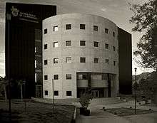
Crime
.jpg)
The city had a serious problem with property crime, especially theft and graffiti by taggers. This situation has exploded in recent years. Also, drug-related murders, including murders of law-enforcement officers by narco-traffickers led by Joaquín Guzmán Loera ("el Chapo", or "Shorty"), (38 in 2007 according to a March 2008 issue of the newspaper Diario de Chihuahua) have been on the rise. The Federal Police and the Army have moved into the city to conduct anti-drug operations; it seems that their activity may have a positive effect; the indices of property crime and murder have fallen[25] since 2010, with the result that Chihuahua is safer now than in years past.
Sports
The city is home of the Dorados de Chihuahua of the Liga Nacional de Baloncesto Profesional, or National Professional Basketball League of Mexico. The city formerly had a baseball franchise in the Mexican League (AAA), also known as the Dorados.
On May 15 & 16, 2010 the city also hosted the 24th IAAF World Race Walking Cup with $122,500 in prize money awarded in the team and individual competitions to the world's fastest walkers at distances ranging from 20 to 50 kilometers (12–31 mi), plus a 10 km (6.2 miles) race for juniors, aged 16 to 19 years of age.
Tourism


The city of Chihuahua offers many places of interest for the tourist, especially the history buff (see Museums of Chihuahua), including the baroque Metropolitan Cathedral, seat of the Archdiocese (and the resting place of St Peter of Jesus Maldonado, a Cristero martyr of the 1930s), dating from the 18th century, the Government Palace from the early 19th century, and the City Hall from the turn of the 20th century, on the Plaza de Armas across from the Cathedral.
During the French invasion and the Second Empire, which ended with the execution of the Habsburg Emperor Maximilian in 1867, the constitutional president, Benito Juárez García traveled the country, searching for support wherever he could. He found it in 1864 when he settled his cabinet and government-in-exile here in the city at the address now known as Ave. Juárez 321, and incidentally, making Chihuahua the only city, aside from Mexico City, to be the capital of the Republic. The Museo Casa Juarez, now known as The Museum of Republican Loyalty, has been faithfully restored to the appearance it had when President Juárez lived here from 1864 through 1866.
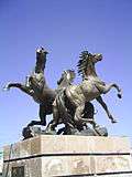
The city offers the service of the touristic "Trolley el Tarahumara" which is a special bus that goes around to all the main museums and monuments in the City Centre(starting its route at the Plaza de Armas), including parks like the Central Park "El Palomar", a large park that has a collection of sculptures, including one depicting three doves (palomas, hence the park's name) and a monumental flagpole, flying one of the largest flags in the Republic, as well as a statue of one of Chihuahua's favourite sons, the late actor Anthony Quinn, in his famous role as 'Zorba the Greek', as well as many others. The city is renowned for its classical and modern sculpture, as seen on any main boulevard or avenue. Included are works by Espino, Baltazar, Ponzanelli and Sebastian, the latter being a native of Chihuahua.

Particularly noteworthy are the murals in the Government Palace and the Paraninfo, or University Auditorium (in the Literary and Scientific Institute building) both depicting the history of the State of Chihuahua, and both fronting upon the Plaza Hidalgo in the city centre, and catter-cornered from the Plaza Mayor. Also of note is the Quinta Gameros, one of the largest estate houses in pre-revolutionary Chihuahua City, now the state museum for the decorative arts, and the former Federal Palace of Chihuahua on Venustiano Carranza Street, north of the Government Palace, which is now a museum and contains the cell in which Miguel Hidalgo spent his final days, and is a national shrine.
The Mammoth Museum, at Gomez Morin (also Calle 27a) and Ave. Juarez, is the city natural history museum and contains 13 halls detailing prehistoric life from the dinosaurs through the reign of the mammals, or the Cenozoic Era. It also has exhibits of prehistoric art. The Semilla Museo Centro de Ciencia y Tecnología, or Seed Centre Museum of Science and Technology, on Teofilo Borunda and Lisboa in the City Centre, is a creative learning centre and interactive science museum for children.
The Feria (Fair) of Santa Rita, known throughout the Republic, is held during the last two weeks of May and features internationally known recording artists in concert. The fair has been held annually for decades. In addition, the University Symphony performs at the Paraninfo weekly during the summer months, and features international guest artists in classical and pop concerts. The Plaza de Toros, or bull ring, 'La Esperanza' is located on Teofilo Borunda on the north side of the river, and features Corridas (Bullfights) during the summer and fall.
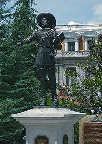
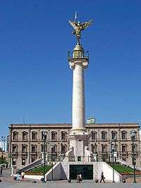
The Plaza Mayor is an important square in the city centre that displays fountains, green spaces and a collection of monuments depicting local heroes. The main monument in the Plaza Mayor is the "Ángel de el Libertad" that was built in 2003 representing the freedom of all Mexicans, especially Chihuahua's people. It was inaugurated during the Independence Day festivities on September 15 of that same year. The angel has a sword with a laser light at the tip, and is capable of rotating 360° over its axis.
Twin towns and sister cities
Chihuahua has two sister cities, as designated by Sister Cities International: [26]
| Country | City | State / District / Region / County | Ref. |
|---|---|---|---|
| |
Albuquerque | |
[27] |
| |
Pueblo | |
[27] |
Notes
- ↑ Station ID for Chihuahua is 76225 Use this station ID to locate the sunshine duration
References
- 1 2 3 4
 Chisholm, Hugh, ed. (1911). "Chihuahua (city)". Encyclopædia Britannica. 6 (11th ed.). Cambridge University Press. p. 134.
 - ↑ "Constitución Política del Estado Libre y Soberano de Chihuahua" (PDF) (in Spanish). H. Congreso del Estado de Chihuahua. July 2010. p. 11. Archived from the original (PDF) on August 16, 2010. Retrieved May 15, 2013.
- ↑ "Chihuahua: Etimología". Archived from the original on 2007-07-01. Retrieved 2007-10-07.
- 1 2 Almada Francisco R (1968). Diccionario de Historia, Geografía y Biografía Chihuahuenses (in Spanish). Universidad de Chihuahua.
- ↑ Salvador Treviño Castro (2000). Del Chihuahua colonial (in Spanish). UACJ. p. 27. ISBN 968-7845-24-4.
- ↑ "Chihuahua: Historia". Retrieved 2007-10-07.
- ↑ Martin, Cheryl (1996). Governance and Society in Colonial Mexico: Chihuahua in the Eighteenth Century. Stanford University Press. pp. 1–2. Retrieved January 29, 2013.
- ↑ http://diario.mx/Estado/2015-12-04_1832a3ad/rinde-protesta-eugenio-baeza-como-alcalde-de-chihuahua/
- ↑ "Chihuahua". Catálogo de Localidades. Secretaría de Desarrollo Social (SEDESOL). Retrieved 23 April 2014.
- 1 2 3 Archived October 15, 2009, at the Wayback Machine.
- 1 2 "Archived copy" (PDF). Archived from the original (PDF) on 2011-10-11. Retrieved 2012-01-25.
- ↑ "Universidad Autónoma de Chihuahua – ORGULLO DE SER UACH". Retrieved 25 June 2015.
- ↑ Peel, M. C.; Finlayson B. L. & McMahon, T. A. (2007). "Updated world map of the Köppen–Geiger climate classification". Hydrol. Earth Syst. Sci. 11: 1633–1644. doi:10.5194/hess-11-1633-2007. ISSN 1027-5606. (direct: Final Revised Paper)
- ↑ Kottek, M.; J. Grieser; C. Beck; B. Rudolf; F. Rubel (2006). "World Map of the Köppen-Geiger climate classification updated" (PDF). Meteorol. Z. 15 (3): 259–263. doi:10.1127/0941-2948/2006/0130. Retrieved December 8, 2012.
- 1 2 "Weatherbase: Historical Weather for Chihuahua, Chihuahua". Weatherbase. Retrieved January 28, 2013.
- 1 2 3 4 "Normales climatológicas para Chihuahua, Chihuahua." (in Spanish). Colegio de Postgraduados. Retrieved January 8, 2013.
- 1 2 3 4 5 "NORMALES CLIMATOLÓGICAS 1951–2010" (in Spanish). National Meteorological Service of Mexico. Retrieved December 11, 2012.
- 1 2 3 "Normales climatológicas para el Estado de Chihuahua" (in Spanish). Colegio de Postgraduados. Archived from the original on April 19, 2012. Retrieved 18 September 2012.
- 1 2 "NORMALES CLIMATOLÓGICAS 1981–2000" (PDF) (in Spanish). Comision Nacional del Agua. Retrieved January 23, 2016.
- ↑ "Weather History for Chihuahua, Mexico". Weather Underground. Retrieved January 28, 2013.
- ↑ "Klimatafel von Chihuahua, Chihuahua / Mexiko" (PDF). Baseline climate means (1961-1990) from stations all over the world (in German). Deutscher Wetterdienst. Retrieved January 23, 2016.
- ↑ "Station 76225: Chihuahua". Global station data 1961–1990—Sunshine Duration. Deutscher Wetterdienst. Retrieved January 23, 2016.
- ↑ "Datos Viales de Chihuahua" (PDF) (in Spanish). Dirección General de Servicios Técnicos, Secretaría de Comunicaciones y Transportes. 2011. pp. 4, 7–8, 13. Retrieved 2011-10-29.
- ↑ "Hoy inaugura EPN Centro de Justicia en Chihuahua, el más grande LA". Radio Formula. Retrieved 6 February 2016.
- ↑ "Tiende a bajar el índice de delitos". Retrieved 25 June 2015.
- ↑ Archived October 25, 2008, at the Wayback Machine.
- 1 2 "Interactive City Directory". Retrieved 25 June 2015.
External links
| Wikimedia Commons has media related to Chihuahua, Chihuahua state. |
-
 Chihuahua travel guide from Wikivoyage
 - (Spanish)−Official City of Chihuahua website
- (Spanish)−Economic Development Office
- Chihuahua video
- Chihuahuan Frontier