Chiefdoms of Hispaniola
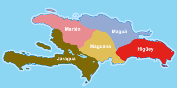
The chiefdoms of Hispaniola (cacicazgo in Spanish) were the primary political units employed by the Taíno inhabitants of Hispaniola (Taíno: Ayiti, Quisqueya, or Bohio) in the early historical era. At the time of European contact in 1492, the island was divided into five chiefdoms or cacicazgos, each headed by a cacique or paramount chief. Below him were lesser caciques presiding over villages or districts and nitaínos, an elite class in Taíno society.
The Taíno of Hispaniola were an Arawak people related to the inhabitants of the other islands in the Greater Antilles. At the time of European contact, they were suffering attacks from a rival group, the Island Caribs. In 1508, there were about 60,000 Taínos in the island of Hispaniola, by 1531 exploitation and disease had reduced the number to 600.
The boundaries of each cacicazgo were clear and precise, the first inhabitants of the island in fact used the natural elements as references, such as major rivers, high mountains, notable valleys and plains. This made it possible to establish the extent of each territory.[1] Each was divided into cacique nitaínos, subdivisions headed by the cacique helpers. The entries below relate the territory of each former cacique to the modern-day departments of Haiti and the provinces of the Dominican Republic.
Chiefdom of Marién

The cacicazgo of Marién included the entire northwestern part of Hispaniola, bordered to the north by the Atlantic Ocean, the south by the cacicazgo of Jaragua, east by the cacicazgos of Maguá and Maguana, and west by the Windward Passage.
It was ruled by the cacique Guacanagaríx, with its capital located in El Guarico, near the present-day city of Cap-Haïtien. It was divided into 14 nitaínos. This cacicazgo was the first to welcome Christopher Columbus and to convert to Christianity.
The cacicazgo of Marién fought against the cacicazgo Mairena, which was aided by Caonabo of the cacicazgo of Maguana for control of the mythical 'Mother' goddess Iermao. The 'Mother' Iermao was the goddess of the cacicazgo of Marién, which means "body stone".
Geographic scope
Dominican Republic
Haiti
Chiefdom of Maguá

The cacicazgo of Maguá was located on the northeastern part of Hispaniola, bordered to the north and east by the Atlantic Ocean, the south by the cacicazgos of Maguana and Higüey, and west by the cacicazgos of Marién and Maguana. This chiefdom's territories are all in present day Dominican Republic. It was ruled by the cacique Guarionex and was centered near the present location of Santo Cerro in La Vega. It was divided into 21 nitaínos. This cacicazgo was one of the richest of the island.
Originally the territory was inhabited by an ethnically distinct group of Taínos called the Ciguayos, which were concentrated on the Samaná Peninsula. This group which spoke ciguayo was absorbed into the cacicazgo of Maguá as is noted by Bartolomé de las Casas who states that in 1502 the language was on the decline and by 1527 extinct.
Maguá means "the Stone" and the chiefdom's mother-goddess was Guacara or the 'Stone Mother'.
Geographic scope
Dominican Republic
- Duarte
- Espaillat
- La Vega
- María Trinidad Sánchez
- Monseñor Nouel
- Puerto Plata
- Hermanas Mirabal
- Samaná
- Sánchez Ramírez
- Santiago
Chiefdom of Maguana

The cacicazgo of Maguana was located in the center of the island, bounded on the north by the cacicazgos of Marién and Maguá, south by the Caribbean, east by the cacicazgos of Maguá and Higüey, and west by the cacicazgos of Marién and Jaragua. This cacicazgos territories were all located in present day Dominican Republic.It was ruled by the cacique Caonabo, husband of Anacaona. Its center was established at Corral de los Indios located in the present day town of Juan de Herrera in San Juan province. It was divided into 21 nitaínos.
This was the principal cacicazgo of the island and was represented as "The Rock". The term Maguana means "the first stone" or "the only stone". The principal mother goddess of the chiefdom was Apito, which means "Mother of Stone".[2]
The cacique Caonabo was the first to resist the Spanish occupation. The fort that Christopher Columbus established on the north coast of the island, La Navidad, was destroyed by Caonabo. Caonabo also attempted to sack Fortaleza de Santo Tomás, but was captured by Spanish forces led by commander Alonso de Ojeda. Instead of being condemned to death the cacique was sent to Spain to be paraded in front of the Royal Court but died on his voyage.
Geographic scope
Dominican Republic
Chiefdom of Jaragua

The cacicazgo of Jaragua spanned the entire south-west of the island of Hispaniola. It was bordered on the north by the cacicazgo of Marién, south by the Caribbean Sea, east by the cacicazgo of Maguana, and west by the Strait of Jamaica. It was ruled by the cacique Bohechio and was the largest of the cacicazgos. Its center was located in a place called Yaguana, present-day Léogane in Haiti. It was divided into 26 nitaínos.
Bohechío was the brother of Anacaona, who was married to the cacique of Maguana; Caonabo. As such, Jaragua and Maguana had a strong alliance and would partner to ward off and attack rival cacicazgos.
The mother goddess of the cacicazgo was Zuimaco.
Geographic scope
Dominican Republic
Haiti
Chiefdom of Higüey

The cacicazgo of Higüey spanned the entire southeast of Hispaniola, bordered to the north by the cacicazgo of Maguá and the Bay Samana, south by the Caribbean, east by the Canal de la Mona, and west by the cacicazgo of Maguana. It was ruled by the cacique Cayacoa and was divided into 21 nitaínos. The capital of the cacicazgo was located in present-day Higüey.
The mother goddess of Higüey was Atabeira, which means "Mother of the original stone".
Geographic scope
Dominican Republic
References
- ↑ (Spanish) Las Casas, Bartolomé de (1552),A Short Account of the Destruction of the Indies "Los reinos que había en la isla Española" Archived December 29, 2010, at the Wayback Machine.
- ↑ (Spanish) Maguana.net
Bibliography
- Las Casas, Bartolomé de (1552) Brevísima relación of destrucción de las Indias, Axel Springer ISBN 84-7700-006-9 SL
- Fombrun, Odette Roy (2006) History of my country, Haiti 1 ISBN 978-99935-0-133-6
- NAU, Charles Emile, baron (1854) "Histoire des Caciques d'Haïti" ISBN 99935-37-18-7