Chicago Portage National Historic Site
| Chicago Portage National Historic Site | |
|---|---|
|
IUCN category V (protected landscape/seascape) | |
 | |
  Map of the U.S. state of Illinois showing the location of Chicago Portage National Historic Site | |
| Location | 4800 S. Harlem Ave., Lyons, Cook County, Illinois, USA |
| Coordinates | 41°48′20″N 87°48′25″W / 41.80556°N 87.80694°WCoordinates: 41°48′20″N 87°48′25″W / 41.80556°N 87.80694°W |
| Established | 1952 |
| Governing body | Forest Preserve District of Cook County |
|
Chicago Portage National Historic Site | |
| Location | 4800 S. Harlem Ave., Lyons, Illinois |
|---|---|
| Area | 91.2 acres (36.9 ha) |
| NRHP Reference # | 66000108[1] |
| Added to NRHP | October 15, 1966 |
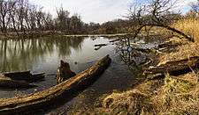
The Chicago Portage National Historic Site is a National Historic Site [2] in Lyons, Cook County, Illinois, United States. It is located in Chicago Portage Forest Preserve, at the junction of Portage Creek with the Des Plaines River, on the west side of Harlem Avenue on the line of 48th Street. Preserved within the park is the western end of the historic portage linking the Chicago River to the Des Plaines River, thereby linking the Great Lakes to the Mississippi River. A memorial depicting the portage of the French explorers is located at the parking area. A trail leads from the memorial down into the portage wilderness area.
The site commemorates the Chicago Portage first written about and used by French explorers Father Marquette and Louis Joliet during their exploration of the area between Lake Michigan and the Mississippi River. The portage crossed what was known as Mud Lake, which could be wet, swampy, frozen, or dry, depending on the season, and which has since been completely obliterated. Mud Lake extended roughly from the historic western end of the South Branch of the Chicago River (near today's Damen Avenue) to the Des Plaines River at this National Historic Site. These explorers understood the importance of the easiest crossing of the continental divide between the Gulf of Mexico and Atlantic Ocean watersheds.
The site, which was designated January 3, 1952 as an "affiliated area" of the National Park Service, is owned and administered by the Forest Preserve District of Cook County. Visitor access is via Harlem Avenue, just north of Interstate 55. The site contains the parking area, a memorial statue, interpretive signs, and trails. Activities here are hiking and canoeing, and the Friends of the Chicago Portage sponsors guided walks. In the future, it is hoped that adjacent vacant industrial land can be used to construct a visitor's center.[3]
References
- ↑ National Park Service (2010-07-09). "National Register Information System". National Register of Historic Places. National Park Service.
- ↑ "CHICAGO PORTAGE NATIONAL HISTORIC SITE". Survey of Historic Sites and Buildings. National Park Service. Archived from the original on 19 October 2012. Retrieved 15 May 2012.
- ↑ The Future of The Past - Friends of the Chicago Portage
External links
- Friends of the Chicago Portage official site
- National Park Service
- Stateparks.com
- 3-D Photosynth of the Sculpture
| Topics | |
|---|---|
| Lists by states |
|
| Lists by insular areas | |
| Lists by associated states | |
| Other areas | |
| |