Chicabal Lake
| Chicabal Lake | |
|---|---|
 | |
| Coordinates | 14°47′N 91°40′W / 14.783°N 91.667°WCoordinates: 14°47′N 91°40′W / 14.783°N 91.667°W |
| Type | crater lake |
| Basin countries | Guatemala |
| Max. width | 575 m (1,886 ft) |
| Max. depth | 331 m (1,086 ft) |
| Surface elevation | 2,172 m (7,126 ft) |
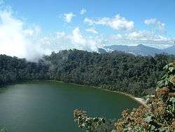
Chicabal Lake is a Guatemalan lake sacred to the Mam Mayan people. The lake is located in the municipal boundary of the town of San Martín Sacatepéquez in the department of Quetzaltenango. A crater lake, Laguna de Chicabal was formed in the crater of Volcán Chicabal at an elevation of 2,712 meters (8,879 feet). The terrain surrounding the lake is a cloud forest.
Chicabal Lake is billed as the center of the Mam-Maya "cosmovision", and Mayan traditionalists still use the several altars on the lake shore. Restrictions are placed on visiting the lake during the early part of May so that Mam people can celebrate their traditional ceremonies without disturbance. Because of its spiritual importance, swimming is prohibited in Chicabal Lake.
This article is issued from Wikipedia - version of the 10/12/2016. The text is available under the Creative Commons Attribution/Share Alike but additional terms may apply for the media files.