Chhapra
| Chhapra छपरा Chapra | |
|---|---|
| City | |
|
Rajendra Sarovar | |
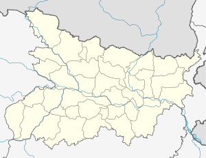 Chhapra Location in Bihar, India | |
| Coordinates: 25°47′05″N 84°43′39″E / 25.7848°N 84.7274°ECoordinates: 25°47′05″N 84°43′39″E / 25.7848°N 84.7274°E | |
| Country |
|
| State | Bihar |
| District | Saran |
| Area | |
| • Urban | 38.26 km2 (14.77 sq mi) |
| Elevation | 36 m (118 ft) |
| Population (2011) | |
| • City | 201,598 |
| • Urban | 249,556 |
| Demonym(s) | Chhaprahvi |
| Languages | |
| • Official | Bhojpuri, Awadhi, Hindi, Urdu, English |
| Time zone | IST (UTC+5:30) |
| PIN | 841301, 841302(Sarha) |
| Telephone code | +916152 |
| Lok Sabha constituency | Saran |
| Vidhan Sabha constituency | Chapra |
| Website |
saran |
Chhapra (also written Chapra) is a city and headquarters of the Saran district in the Indian state of Bihar. It is situated near the junction of the Ghaghara River and the Ganges River.
Chhapra grew in importance as a river-based market in the 18th century when the Dutch,[1][2] French, Portuguese, and English established saltpeter refineries in the area. It was recognized as a municipality in 1864. The city has major rail and road connections with the rest of India and a distance of few minutes from Uttar Pradesh by Train. There is a well known[3] shakti peeth temple in Chhapra named Ambika Bhavani.
Geography


Chhapra is located at 25°47′05″N 84°43′39″E / 25.7848°N 84.7274°E.[4] It has an average elevation of 36 metres (118 ft).
Climate
| Climate data for Chhapra | |||||||||||||
|---|---|---|---|---|---|---|---|---|---|---|---|---|---|
| Month | Jan | Feb | Mar | Apr | May | Jun | Jul | Aug | Sep | Oct | Nov | Dec | Year |
| Average high °C (°F) | 23.1 (73.6) |
25.8 (78.4) |
31.0 (87.8) |
35.1 (95.2) |
35.0 (95) |
34.9 (94.8) |
32.5 (90.5) |
32.8 (91) |
32.5 (90.5) |
31.6 (88.9) |
29.0 (84.2) |
24.8 (76.6) |
30.68 (87.22) |
| Average low °C (°F) | 9.2 (48.6) |
11.0 (51.8) |
15.1 (59.2) |
19.1 (66.4) |
21.2 (70.2) |
22.9 (73.2) |
23.8 (74.8) |
24.2 (75.6) |
23.8 (74.8) |
21.2 (70.2) |
15.8 (60.4) |
10.6 (51.1) |
18.18 (64.72) |
| Average precipitation mm (inches) | 13.0 (0.512) |
14.0 (0.551) |
9.0 (0.354) |
29.0 (1.142) |
76.0 (2.992) |
139.0 (5.472) |
353.0 (13.898) |
254.0 (10) |
193.0 (7.598) |
73.0 (2.874) |
6.0 (0.236) |
7.0 (0.276) |
97.17 (3.8256) |
| Source: Accuweather[5] | |||||||||||||
Demographics
As per 2011 census, Chapra Urban Agglomeration had a population of 212,955.[6] Chapra Urban Agglomeration includes Chapra (Nagar Panchayat) and Sandha (Census Town).[7] chapra Nagar Panchayat had a total population of 201,597, out of which 106,250 were males and 95,347 were females. It had a sex ratio of 897. The population below 5 years was 27,668. The literacy rate of Chhapra was 81.30 per cent as 2011.[8]
Education
- Jai Prakash University
- Loknayak Jai Prakash Institute Of Technology,Saran[9]
- Rajendra College
- Jila School
- Saran Academy School
- Brahman High School
- Rajendra Collegiate
- Jagdam College
- Radiance Institute Of IT & Management (RIIM)
- Sadhu Lal Prithvi Chand High School & College, Sidhi Ghat Chapra
- Sant Jaleshwar Academy Bara Louwa Baniapur
Gallery
 Rajendra College, Chhapra
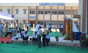 Loknayak Jai Prakash Institute Of Technology
People from Chhapra
- Dr. Rajendra Prasad, freedom fighter and first president of India
- Jayaprakash Narayan, Political Leader From Sitabdiyara, Chhapra
- Bhikhari Thakur, poet and singer, "Shakespeare of Bhojpuri"
- Brajkishore Prasad, National Activitist
- Daroga Prasad Rai , 10th Chief Minister Of Bihar.
- Laloo Prasad Yadav ,Past Member of Parliament from Saran Constituency, Past Chief Minister of Bihar, Past Railway Minister Of India.
- Er Sachchidanand Rai MLC Saran Bihar Legislative Council.
- Surur Hoda, Socialist leader and Order of British Empire (OBE) recipient.
- Chitragupta (composer), music director and father of composers Anand-Milind
- Anand-Milind, Music Composer and the sons of Chitragupta (composer).
- Mansur Hoda, Technologist, An alumnus of Surrey University, England.
- Qamar Ahmed, BBC cricket correspondent URDU,Hindi and English
Service,The Times,The Daily telegraph, The Guardian reporter and World Cup 1992 commentator.
See also
References
- ↑ Atlas of Mutual Heritage
- ↑ Atlas of Mutual Heritage
- ↑
- ↑ Falling Rain Genomics, Inc - Chapra
- ↑ "Accuweather: Weather for Chhapra, India". Accuweather. 2011. Retrieved on November 22, 2011.
- ↑ "Urban Agglomerations/Cities having population 1 lakh and above" (PDF). Provisional Population Totals, Census of India 2011. Retrieved 2012-04-16.
- ↑ "Constituents of urban Agglomerations Having Population 1 Lakh & above" (PDF). Provisional Population Totals, Census of India 2011. Retrieved 2012-04-16.
- ↑ "Cities having population 1 lakh and above" (PDF). Provisional Population Totals, Census of India 2011. Retrieved 2012-04-16.
- ↑ "CM inaugurates new engineering college at Chhapra". The Times Of India. 26 December 2012. Retrieved 26 December 2012.
External links
Railways in Bihar | |||||||||||||||||||
|---|---|---|---|---|---|---|---|---|---|---|---|---|---|---|---|---|---|---|---|
| Network Lines Sections |
| ||||||||||||||||||
| Rail Bridges | |||||||||||||||||||
| |||||||||||||||||||