Cheyenne Mountain Air Force Station
| Cheyenne Mountain Air Force Station[1] | |
|---|---|
| Part of United States' Air Force Space Command | |
| Colorado Springs, Colorado | |
 | |
| Coordinates | 38°44′37.57″N 104°50′48.40″W / 38.7437694°N 104.8467778°W |
| Type | Air Force Station[1] |
| Site information | |
| Controlled by | Air Force Space Command[2] |
| Site history | |
| Built | 1961–1965 |
| Built by | United States Army Corps of Engineers |
| In use | 1965–Present |
| Battles/wars | Cold War |
Cheyenne Mountain Air Force Station (CMAFS) is located within Cheyenne Mountain on the Front Range of the Rocky Mountains in Colorado Springs, Colorado. The Cheyenne Mountain Complex was first built for the North American Aerospace Defense Command (NORAD).
Background
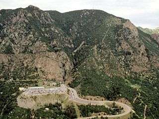
Until 2006, Cheyenne was the center for the United States Space Command and NORAD which monitored the air space of Canada and the United States through a worldwide system for early warnings of missiles, space systems, and foreign aircraft. The operations center was moved from an above-ground facility, vulnerable to missile or bomber attack, to the "granite shielded security" within Cheyenne Mountain during the Cold War as the Cheyenne Mountain Complex. The complex was built in the mid-1960s, began operations in 1966,[3][4] and NORAD's Combat Operation Center was fully operational on February 6, 1967.[2] Today the Air Force Station is used as a pilot training center and is skeleton crewed and maintained as an alternate command center.[5] It has its own power plant, heating and cooling system, and water supply. It was built under 2,000 feet (610 m) of granite on five acres.[6] Structures outside of the military complex include the parking lots and roads, a heliport,[7][lower-alpha 1] and the fire station.[8][lower-alpha 2] Outdoor facilities include Mountain Man Park, picnic areas, a raquetball facility, softball field, sand volleyball, basketball, a putting green, and horseshoes.[9] There is a fitness center inside and outside the mountain.[9] The portals for the blast tunnel are entered off the parking lot. A military gate limits NORAD Road usage from the State Highway 115 interchange.
The military complex has, in the past, included many units of NORAD, U.S. Space Command, Aerospace Defense Command (ADCOM), Air Force Systems Command, Air Weather Service, and Federal Emergency Management (FEMA). The complex's communication center is also used by the nearby U.S. Civil Defense Warning Center.[3] The station has an exercise, weights, and cardio gym that is open 24 hours a day.[9]
Air Force Space Command units are under the command of the Peterson Air Force Base.[10] Colorado Springs has a number of military installations. The others are Fort Carson, Peterson Air Force Base, the United States Air Force Academy.[4] and Schriever Air Force Base.
Air Force Space Command
The entire installation at Cheyenne Mountain was designated the Cheyenne Mountain Air Station by February 1995.[11] In 2000, the installation was renamed Cheyenne Mountain Air Force Station. That year all Air Force Space Command Air Stations in the United States have been redesignated as Air Force Stations.[1] The Air Force Station is the site of NORAD's Air Defense Operations Center.[12]
Cheyenne Mountain Air Force Station is supported and operated by the 21st Space Wing, which is headquartered at Peterson Air Force Base and under the command of the U.S. Strategic Command and NORAD. It is managed by the 21st Operations Group.[13] The 21st Space Wing operates radar systems in the United States and worldwide, monitoring for launches of ballistic missiles and new space systems up to 22,300 miles (35,900 km) above the earth.[13] As of 2014, there are at least 20 countries able to launch long-range weapons, including chemical, biological, and nuclear weapons.[13] Base support and logistical services are provided by the 21st Mission Support Group. Equipment and facilities, including the Integrated Tactical Warning and Attack Assessment (ITW/AA) weapon system, are operated and maintained by the 721st Mission Support Group of the 21st Space Wing.[13][14] The support group is located at Cheyenne Mountain.[14] The 721st Civil Engineering Squadron operated from 1966 under Col. Joseph Turk, 721st Mission Support Group Commander. In 2004, its functions were outsourced. The last active duty commander was Lt. Col. Todd Wynn, who is now retired. It was re-activated on July 17, 2012, bringing some of the functions in-house under civilian employees, led by Dino Bonaldo I, a civilian squadron commander. The civil engineering squadron is responsible for the engineering, maintenance, and operation of the complex.[6]
In 2006, the Space Control Center, the command and control hub for space surveillance in the United States, transferred its operations to the Joint Space Operations Center from Cheyenne Mountain Air Force Station. The Space Control Center belongs to the 14th Air Force and the Air Force Space Command; it is not part of NORAD or U.S. Northern Command. The Air Force Space Command headquarters remained at the Cheyenne Mountain Air Force Station.[15]
Global warning functions within the complex include the North American Aerospace Defense Command/U.S. Northern Command's Alternate Command Center, U.S. Strategic Command's Missile Warning Center, the 721st Global Strategic Warning/Space Surveillance System Center of the Integrated Tactical Warning/Attack Assessment system.[16]
The Missile Warning Center was upgraded in June 2011, upon completion of a $2.9 million project over 18 months. It was funded by USSTRATCOM and resulted in newer computers, more efficient workspace, a new knowledge visual display, new joint worldwide intelligence communication systems, and a new electronic procedural checklist.[17]
Tons of debris built up at the entrance to the Cheyenne Mountain Air Force Station following heavy rainfall and a resulting rock slide in September 2013. The 4th Infantry Division, with support by the 615th Engineer Company, 52nd Engineer Battalion, of Fort Carson cleared away the debris from a rockslide and uprooted trees. The storm and resulting debris did not limit the Air Force Station's operations, according to the 721st Mission Support Group's commander Col. Travis Harsha,[18] who became commander on July 11, 2013 for the now retired Col. Joseph Turk.[19]
On September 5, 2013, Cheyenne Mountain Air Force Station hosted an event with Federal Bureau of Investigation (FBI), local sheriffs and police chiefs, Army security forces, and Air Force security across several military installations about partnering for law enforcement and emergency management events, like terrorist threats, criminal activity, and forest fires. Partnering with law enforcement and the community helps to "foster information sharing and maximize joint training opportunities," according to Col. Travis Harsha, the CMAFS installation commander and 721st Mission Support Group Commander.[20]
Cheyenne Mountain
The facility is adjacent to the Cheyenne Mountain State Park.[21] A telecommunication antenna farm is located on the highest point[4][22] and Pike National Forest is on the west side of the mountain.[4][23][24] The mountain is also the site of the Cheyenne Mountain Zoo and Will Rogers Shrine of the Sun.[4]
Notes
- ↑ The heliport is located off Norad Road, before the parking lot, at 38°44′29″N 104°50′03″W / 38.74139°N 104.83417°W.[7]
- ↑ The fire station is located at 38°44′29″N 104°50′03″W / 38.74139°N 104.83417°W.[8]
References
- 1 2 3 "City". The Gazette. Colorado Springs, CO. February 5, 2000. Retrieved February 19, 2015 – via HighBeam Research. (subscription required (help)).
- 1 2 "Cheyenne Mountain Complex". NORAD. Retrieved February 19, 2015.
- 1 2 Joseph Angelo (31 October 2013). Dictionary of Space Technology. Routledge. p. 70. ISBN 978-1-135-94402-5.
- 1 2 3 4 5 "From NORAD to Parks: A Tale of the Cheyenne Mountain Project" (PDF). Colorado Open Lands. Retrieved January 31, 2015.
- ↑ http://www.norad.mil/About-NORAD/Cheyenne-Mountain-Air-Force-Station/
- 1 2 Johnson, Lea (July 30, 2012). "721st MSG activates squadron, appoints leadership". Air Force Space Command. Retrieved July 3, 2016.
- 1 2 "Cheyenne Mountain Heliport". Geographic Names Information System. United States Geological Survey. Retrieved 2012-07-25.
- 1 2 "Cheyenne Mountain NORAD Air Force Station Fire Department". Geographic Names Information System. United States Geological Survey. Retrieved 2012-07-25.
- 1 2 3 "Peterson Air Force Support Squadron: CMAFS". Peterson Air Force Base. Retrieved February 20, 2015.
- ↑ Joseph Angelo (31 October 2013). Dictionary of Space Technology. Routledge. p. 16. ISBN 978-1-135-94402-5.
- ↑ Orban, SSgt. Brian (February 1995). "The trip wire". Guardian. Air Force Space Command: 6.
missile warning center at Cheyenne Mountain AS
- ↑ Joseph Angelo (31 October 2013). Dictionary of Space Technology. Routledge. p. 276. ISBN 978-1-135-94402-5.
- 1 2 3 4 "Fact Sheet: 21st Space Wing". Peterson Air Force Base. Retrieved February 20, 2015.
- 1 2 "21st Space Wing: Units". Peterson Air Force Base. Retrieved February 20, 2015.
- ↑ "Media Advisory: Space unit to move from Cheyenne Mountain". September 15, 2006. Retrieved February 20, 2015.
- ↑ "Cheyenne Mountain AFS visit". Peterson Air Force Base. July 23, 2013. Retrieved February 20, 2015.
- ↑ "Cheyenne Mountain unveils renovated Missile Warning Center". Peterson Air Force Base. July 23, 2010. Retrieved February 20, 2015.
- ↑ Staff Sgt. J. Aaron Breeden, 21st Space Wing Public Affairs (September 18, 2013). "Joint team clears flood debris from mountain entrance". Peterson Air Force Base. Retrieved February 20, 2015.
- ↑ Staff Sgt. J. Aaron Breeden, 21st Space Wing Public Affairs (July 16, 2013). "Mountain gets new commander". Peterson Air Force Base. Retrieved February 20, 2015.
- ↑ Michael Golembesky, 21st Space Wing Public Affairs staff writer (September 10, 2013). "Cheyenne Mountain builds upon partnership". Peterson Air Force Base. Retrieved February 20, 2015.
- ↑ Maryann Gaug (March 23, 2010). "Cheyenne Mountain State Park". Best Hikes Near Denver and Boulder. Falcon Guides. p. 98. ISBN 978-0-7627-6223-1.
- ↑ Steven Saint (January 8, 2002). "The Springs' other mountain: There's a lot more to Cheyenne than NORAD". The Gazette. Colorado Springs. Retrieved January 31, 2015 – via HighBeam Research. (subscription required (help)).
- ↑ "Mount Big Chief (see upper right)" (PDF). National Forest Service. Retrieved February 2, 2015.
- ↑ "Cheyenne Mountain (see upper left)" (PDF). National Forest Service. Retrieved February 2, 2015.
Further reading
- Staff Sgt. J. Aaron Breeden, 21st Space Wing Public Affairs (June 11, 2013). "Mountain, man legacies intertwined". Peterson Air Force Base.
- Michael Golembesky, 21st Space Wing Public Affairs staff writer (November 13, 2013). "Cheyenne Mountain firefighters recognized for valor". Peterson Air Force Base.
External links
| Images | |
|---|---|
|
| |
|
| |
| Video | |
|
| |
|
| |
|
|