Chesterton Road, Cambridge


Chesterton Road (part of the A1303) is a road in the north of Cambridge, England.[1][2] The southwestern part of the road is known as Chesterton Lane. This links with Northampton Street at the junction with Castle Street to the northwest and Magdalene Street leading southeast across the River Cam into central Cambridge. At the northeastern end there is a roundabout, linking with Elizabeth Way (the A1134) to the south, continuing Cambridge's inner ring road to the east. Halfway along Chesterton Road there is a major junction with Victoria Road northwest and Milton Road northeast (both part of the A1134) and Victoria Avenue over the Cam on Victoria Avenue Bridge to the south. Chesterton Lane and Chesterton Road form the northern part of the Cambridge inner ring road and thus have heavy traffic at times.
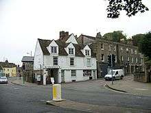
To the northwest of Chesterton Lane is St Giles' Church and Castle Hill, the location of the historic Cambridge Castle. On the opposite corner at the southwestern end of Chesterton Lane is the Museum of Cambridge, formerly the Cambridge & County Folk Museum, on Castle Street. To the southeast of Chesterton Lane is Magdalene College.
In October 2000, archaeologists excavating a sewerage shaft at the corner of Chesterton Lane and Magdalene Street discovered a collection of 13th- and 14th-century coins. Lying in the remains of a disintegrated wooden box, on the site of what was once a house, the hoard totalled 1,805 silver pennies and nine gold coins.[3] The cache is now in the Fitzwilliam Museum.
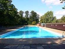
Immediately to the south of the eastern part of Chesterton Road and running parallel for a distance is the River Cam before it splits from the road turning southeast for a short distance. In the south bank of the river here is Jesus Green, named after Jesus College to the south of the Green. Jesus Lock and a footbridge on the Cam link Chesterton Road with Jesus Green for pedestrians. Close by is Jesus Green Swimming Pool, a very long lido.
References
Coordinates: 52°12′47″N 0°07′11″E / 52.21293°N 0.11982°E