Chester Basin
Chester Basin was a tidal basin on the River Mersey, in Liverpool, England. The basin was situated between the Pier Head and Manchester Dock.
History
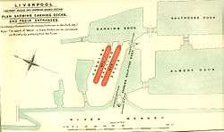
The basin was built between 1785 and 1795,[1] opening in 1795 as the Chester and Ellesmere Basin, and was 2,568 sq yd (2,147 m2) in area.[2] The basin was used by canal boats which had entered the river at Ellesmere Port, as well as other small craft on the Mersey,[2] and was owned by the Shropshire Union Railways and Canal Company.[3] The basin was filled in between 1928–36, with some of the spoil excavated during the construction of the Queensway Tunnel.[2]
In 2007, during the construction of the Liverpool Canal Link, the site was excavated. The excavation revealed various carved stones, which were identified as being from the Liverpool Town Hall of 1673.[4]
References
- ↑ "Ferry Terminal Pierhead, Liverpool, Merseyside - Archaeological Evaluation Report" (PDF). Oxford Archaeology North. February 2008. pp. 9, 29. Retrieved 5 September 2016.
- 1 2 3 McCarron & Jarvis 1992, pp. 25–26
- ↑ Jarvis 1988, p. 24
- ↑ "Liverpool Canal Link, May 2007 - page 2". Pennine Waterways. Retrieved 5 September 2016.
Sources
- Jarvis, Adrian (1988). Docks of the Mersey. Ian Allan. ISBN 9780711015333. OCLC 18521920.
- McCarron, Ken; Jarvis, Adrian (1992). Give a Dock a Good Name?. Birkenhead: Merseyside Port Folios. ISBN 9780951612941. OCLC 27770301.
Further reading
- "Nomination of Liverpool - Maritime Mercantile City for Inscription on the World Heritage List" (PDF). Department for Culture, Media and Sport. 2003. p. 121. Retrieved 5 September 2016.
Coordinates: 53°24′13″N 2°59′46″W / 53.4036°N 2.9961°W